
Cityscape of liveable cities 1970-1979
“First of all, the question of whether the introduction of a building and residential building that contrasts strongly with the environmentfitted in with the new policy, which after all wanted to maintain what could be maintained.” (Nuij, 1973: 13)
“The objectives memorandum contained two main points, namely that the new residential buildings had to be affordable for the majorityof the residents of the Schilderswijk and had to be in line with the existing environment.” (Nuij, 1973: 20).
THE SCHIZOPHRENIC PERIOD, BETWEEN CIAM AND RESIDENTS
CONFUSION EVERYWHERE
On a sunny day on September 17, 1974, Alderman Nuij of urban development anchored the first pile at no less than four iconic urban ensembles from this time in The Hague. The alderman even proclaimed this festive day as the ‘Haagse Bouwdag’. However, ‘The Festivities were, as would soon become apparent, in inverse proportion in quality to the urban and architectural results’ as architect Reiner Bullhorst argued (Boven, 1997: 28).
For the first project along the boulevard next to the Kurhaus, one of the largest fin-de-siècle monuments was demolished, the Grand Hotel of the architect Van Liefland. A poor housing project replaced it, with which the German architects Storch and Ehlers cut off the boulevard, beach, and sea from the city for good. The real estate developer was the daughter of Brederode Bouwbedrijf, Maatschappij Projectontwikkeling (MPO), which also took care of the Kurhaus. The second urban ensemble was the two ministries on the Turfmarkt. The third project was Babylon, a shopping and office center next to the station where the alderman spoke in laudatory terms about the interior of bronze, mirror glass, wood, and brown tiles of the interior architect flown in from Paris. The fourth project was one of the first super-urban-blocks in The Hague, De 444 in the Schilderswijk, by the architects Van Randen and Van Schagen, which gave building for the inhabitants of the neighborhood or the building-for-the-neighborhood initiative (‘bouwen-voor-buurt’) a starting point.
The city image of a livable city took shape, color, and place within the city with the construction of large urban ensembles during the first wave of urban renewal. Residential complexes with significant building flows were incorporated into the city’s existing morphology but, at the same time, within the building lines, the original structure of the city was erased. Urban ensembles such as The 444 and The Gortmolen in the Schilderswijk, The Schippersbuurt in Laakhavens, Het Vierkant Kortenbos, and ZHB-Hoven in the Kortenbos, as well as in various places where monumental military buildings were once located and had been demolished. These urban ensembles aimed to improve the quality of life for residents through building-for-the-neighborhood initiatives with affordable apartments, incorporation of cars and parking. This is how the super urban blocks of urban renewal came into existence.
An essential element in making The Hague was the contrast, or rather, the schizophrenic situation, according to Hans van Beek, Joop ten Velden, Peter Drijver, Adri Duivesteijn, and Gerard van Otterloo cum suis during interviews.
On one hand, CIAM’s city divided in function-based zones: dwelling, work, and recreation connected with through and ring roads. Dwellings in the new neighborhoods such as in Southwest, Mariahoeve and Loosduinen. Work and recreation in the old town wherehistoric buildings and morphological structures were replaced. On the other hand, ‘building-for-the-neighborhood’ with super urban blocks of urban renewal, in which the old city center and nineteenth-century neighborhoods were demolished in favor of the residents.
On the one hand, the department under director Van der Sluijs continued to work on a new center for The Hague (De Nieuwe Hout,Bezuidenhout C) and suburbanization (cauliflower neighborhoods around Loosduinen) with the Municipal Design Structural plan (1970 –called ’the blue monster’ by urban planners), which was never accepted by the council. On the other hand, alderman Nuij worked withhis rehabilitation policy to restore the morphology of the city and build-for-the-neighborhood. Two clashing cityscapes: CIAM versusbuilding-for-the-neighborhood with its urban renewal.
This chapter describes the schizophrenic situation and conflicts in The Hague, as well as the arrival of super urban blocks during urban renewal. The first paragraphs outline the backgrounds and motives of alderman Nuij and others, followed by an explanation of the super urban blocks. Subsequently, there is a brief discussion regarding the growing focus on historic buildings and a summary of an emotional debate among stakeholders about the class of two The Hague’s city images.
THE TURN OF 1970-1974
The city’s schizophrenia was partly due to the delay in decision-making by administrators and the significant influence on the government of project developers, such as Zwolsman, on the city. There was also a generational conflict that unfolded during these years.
Willem Nuij (PvdA), who had previously worked as a director at the PTT, served as the alderman for urban development from 1970 to 1976. He was described as an authoritarian and powerful figure, earning the nickname ’the little general’ from some. Nuij held this position without much expertise in urban planning and architecture, allowing various projects to proceed, perhaps influenced by the circumstances. The new generation of social democrats viewed Nuij as part of the ‘old guard,’ while veteran party members, urban planners, and architects saw him as someone who did not grasp the principles of the CIAM that had been vigorously pursued in the sixties under former aldermen like G.W. Hylkema (PvdA: 1962-1970), Mr. A.J. Dankelman (VVD: 1962-1970), and later alderman for Housing and Neighbourhood Contacts, Toon van Hagen (PvdA: 1974-78).
During the period 1970-74, Van Hagen held the position of chairman of the PvdA, retaining significant influence on public housing policy, which focused on demolition and new construction. He played a crucial role at the Union’s Bouwbond, served as chairman of the General Housing Association, and was a board member of the Social Fund for the Construction Industry. There were claims that Van Hagen had ties with building contractors. Residents and politicians from the ’74 generation referred to him as ‘Teun the Destroyer’ (‘Teun de Sloper’) reflecting his reputation for aggressive urban renewal initiatives. In summary, he was a powerful figure.
While Nuij aligned his approach with CIAM ideas, he also promoted building-for-the-neighborhood and the restoration of the city’s morphology. Nuij demonstrated concern for the marginalized residents, including stragglers and immigrants, in the partially boarded-up and demolished nineteenth-century neighborhoods. After the criticism of the aggressive urban renewal under Van Hagen, Nuij was able to reassure the Council of The Hague.
“A note that will receive no attention is the remediation note from 1956 discovered by Mr. IJmkers. It will reassure him that only a few officials remembered that such a thing existed. Eventually, a copy was discovered in the archive. Quietly left there. Apparently, the note left no traces.” (Council proceedings of 14 November 1973 on the municipal budget of 1974: 957)
This remark is quite remarkable considering the extensive urban renewal efforts that had already significantly impacted the old city, leading to the boarding up or demolition of many buildings and the creation of large sandy plains in the center. Despite the ceremonial event where Nuij symbolically laid the first pile for the flats in Het Kortenbos, he also played a pivotal role in shifting the mindset about the city and demonstrating care for the quality of life.
The instability and schizophrenic situation in the city were also a result of significant societal changes that were reflected in both national and local elections. The local elections of 1970 did not mark the end of years of reflective collegiate governance and coalitions among the traditional ruling parties. During this time, the executive board comprised three aldermen from Social Democrats, two from Liberals, and two from Christian Democrats. New parties, such as ‘D66’ and ‘Kabouters’, also emerged in the council, ushering in a revolution with many inexperienced councilors against a backdrop of a large civil service that continued its established path, with an alderman backing their actions even though lacking full understanding. In 1970, the political landscape in The Hague underwent significant changes, influenced by national events like the general depillarization of the society, the radicalization of youth, resistance to the public housing policies of the Cabinet of Piet de Jong (which, led by Minister Schut, would considerably raise rent costs), and the clear stance taken by the Social Democrats New Left faction. Interestingly, De Jong himself purchased one of the most beautiful apartments in the newly built housing complex, Couperusduin.
The societal schizophrenia was also evident within the local governing parties, where many young local politicians of the ‘generation ’74’ expressed discontent with the old guard and its regent-like governance style. Conflicts emerged within the Hague parties between the old and new guards, particularly after a decline in 1974 when the old guard within the governing parties sought to maintain the status quo. A significant source of contention for many citizens during this period was the unbridled demolition fervor displayed by both project developers and the municipality.
THE DEMOLITION OF THE KURHAUS AS A CATALYST FOR PROTEST
In 1973, Zwolsman’s bulldozers arrived at the Kurhaus, which was the final bastion of the fin de siècle era, sparking a fierce conflict with residents and marking a pivotal moment in the city’s collective mindset. Alongside hippies, and rebellious architects, the entire populace became embroiled in the demolition issue, expressing outright rage (Rosenberg et al., 1988: 314-321). The city was undergoing a significant shift in its perception. Prior to this, in 1968, the main building by the architect Wesstra in the Zoo was demolished, following the destruction of the glass palace by the architect Van Liefland in 1969. Buildings that many citizens had fond memories of. In 1964, the monumental Building of Education, Arts, and Sciences by the architect Gugel had burned down. Notably, this was not the first time a building owned by Zwolsman had burned down after being denied a demolition permit. Earlier in Scheveningen, multiple fin de siècle buildings owned by Zwolsman had similarly been destroyed in fires.
The Kurhaus stood as the last grand fin de siècle monument in The Hague, symbolizing the end of an era. The entire bourgeoisie had turned against the politics that allowed figures like Zwolsman to operate unchecked and exert influence over the city. The municipality faced a dramatic situation. In 1960, The Hague had 606,110 inhabitants; by 1970, the population had decreased to 555,613, and the exodus accelerated further, with only 456,376 residents remaining by 1980 – a 25% decline in population (https://denhaag.incijfers.nl).
Many affluent residents were opting to leave the city. Trust in politics among the people of The Hague hit an all-time low. The old ruling parties, in collaboration with housing associations, construction firms, and entrepreneurs like Zwolsman, were perceived by citizens as having severely damaged the city. For many residents, the demolition of the Kurhaus served as evidence that the municipality executive was squandering the city to benefit profit-driven developers.
Notably, the founding of significant movements like Vrienden van Den Haag (Friends of The Hague) in 1973 – where prominent individuals from The Hague united against city demolition – highlighted the growing opposition to the city’s urban renewal direction. Architectural protests against the demolition projects and the diminishing quality of life also materialized through groups like Dooievaar of some architects. Local newspapers, such as De Haagse Courant, played a pivotal role, with journalists daily depicting and narrating the city’s decline through photographs. Further details on this topic will be explored later in this chapter.
THE NATIONAL PLOTS AND THE INNER RING ROAD AND THE ROLE OF THE CENTRAL GOVERNMENT
An uncertain factor for the city of The Hague was also the unpredictability of the state and its consequences for the city. In 1965, the government and the municipality of The Hague entered a plot agreement through which the state acquired over 100,000 m2 of land divided among 6 lots for approximately 140 million euros (Zwinkels, 1982). Initially, only one lot, Lot 2, was available for immediate use. The remaining lots consisted of existing city areas with predominantly nineteenth century, and sometimes seventeenth-century, buildings.
In 1975, the Palace of Justice, a modern building designed by architect F. Sevenhuijsen, who was the Deputy Government Architect at the time, was constructed on Lot 2. The municipality prepared the six plots for development, arranged the necessary infrastructure, and the government committed to purchasing these plots. The national plots were strategically located within the city, near access roads, the inner ring road, and the station. In the development of the national plots, extensive demolition occurred in Bezuidenhout-West and Rivierenbuurt.
It wasn’t just the national administration. The Ministry of Transport, Public Works, and Water Management sought to build the Utrechtsebaan, which was finalized in 1976. The municipality of The Hague imposed a condition that the intersection with the Prins Bernhard viaduct be included in the project. Construction on the viaduct began in 1974 and was fully completed in 1979. Many old structures and buildings were demolished.
Since the adoption of the Bezuidenhout-C Reconstruction Plan, the council faced a steady stream of objections from residents, shopkeepers, organizations, and companies (Sluijs, 1989) regarding the ambitious projects of the municipality. One noteworthy group was the ‘Cooperative Association for the Promotion of Interests,’ known as the ABC, actively involved in opposing the ‘Demolition Bezuidenhout-C.’ The ABC criticized the municipality extensively and proposed numerous amendments. The core criticism revolved around the municipality’s aim to execute a drastic urban transformation/replacement without involving proper procedures.
Originally, the ‘reconstruction plan’ was designed to swiftly address war-related damage. However, only ten percent of the area had such damage, which had been already repaired by 1962. Despite this, the city continued the ideals of urban development outlined in the reconstruction plan, resulting in expropriation and demolitions. The objections raised against the plan were not given due consideration by the city council.
The Prins Bernhard viaduct road was deemed an essential component of the urban planning strategy and, in the view of the authorities at the time, was indispensable for significant improvements in urban planning, particularly concerning traffic.
The anticipated benefits of the viaduct were seen as non-measurable in economic terms. Originally, the crossroad was planned to be at ground level to accommodate sunken tracks, but the Dutch Railways (NS) later decided against this approach. The city council, aligned with its city executive, saw no compelling reason to challenge the proposed policies.
Despite objections raised, which were largely dismissed as unfounded barring minor details, the council unanimously endorsed the construction of the viaduct as a vital segment of the inner ring road. The urban landscape had already undergone significant demolition, and the groundwork for reconstruction was seen as commencing with the viaduct’s construction. However, public trust in local politics had reached an all-time low during this period.
THE DISASTROUS DISPERSAL POLICY OF 1972 AND THE FURTHER DECLINE OF THE CITY
The national government, under the confessional-liberal Cabinet Biesheuvel, played a significant role in the decline of The Hague and the exodus of its inhabitants, notably due to the disastrous dispersal policy of the ministries in 1972. As part of the reconstruction plan agreed upon in 1965, plots were allocated in The Hague for constructing government offices. Following the demolition of sections of the non-bombed Bezuidenhout, Spuikwartier, and Rivierenbuurt, Minister Udink (from the Christian Historical Union) implemented the distribution policy.
The consequence was that The Hague was left with vast expanses of cleared land bordered by derelict buildings, resulting in severe financial implications for the city. The decision mandated that government services relocate away from The Hague to other regions of the country. This displacement affected approximately 16,000 civil servants, equivalent to 50,000 to 60,000 inhabitants, or about 10% of the households in The Hague, leading to a significant population decrease. In 1960, The Hague had 605,000 residents, but by 1972, the population had decreased to 510,000 (Gemeente Den Haag, 1973).
After enduring the challenges with the CIAM ideas and the first urban renewal initiatives based on demolition of everything The Hague was now further impacted by the state’s actions, delivering what seemed to be the final blow to the city.
At a congress on June 7, 1973, regarding the formation of regions, former Zuid-Holland deputy, Mrs. Chr. de Ruijter-de Zeeuw (PvdA), a veteran member of the Provincial Executive for 24 years, shared a thought-provoking statement. She emphasized that only those with financial resources and mobility could escape the city, leaving behind in the urban core the elderly, individuals below the wealth threshold, the disabled, and those facing challenges in relocation. De Ruijter-de Zeeuw questioned the appeal of suburban living, specifying that the main allure lies in the proximity to the vibrant city. She argued that addressing these societal issues necessitated the creation of regional strategies (Ruijter de Zeeuw, 1973). De Ruijter-de Zeeuw highlighted the ongoing developments in spatial planning, expressing concern that municipalities, provinces, and the national government lacked a cohesive national spatial policy, leading to fragmented and rather haphazard approaches. She preferred the term ‘sectoral’ over ‘random’ policies to describe this approach. In her view, the traditional division among municipal, provincial, and central government roles had lost coherence, resulting in an internal erosion impacting the overall quality of the environment. The oil crisis further exacerbated existing challenges, stalling new construction projects, and compelling individuals to focus on maintaining and refurbishing older buildings instead. De Ruijter-de Zeeuw cautioned against excessive focus on theoretical discussions and deliberations, emphasizing the importance of robust spatial policies and meaningful local governance practices to address these urban issues effectively.
DEN UYL CABINET 1973-1977 AND THE CULTURAL CHANGE AT THE GOVERNMENT BUILDINGS AGENCY
In the years 1972 and 1973, housing production in The Hague reached an unprecedented low. The impact of the oil crisis likely contributed to this decline, as higher energy prices resulted in increased construction costs. In 1972, only around fifty houses were completed, and in 1973, just over a hundred houses were finished. Alderman Nuij took measures to alleviate some of the effects of this downturn by establishing municipal housing grants. Meanwhile, the central government provided subsidies for expropriation and demolition to facilitate urban development projects, highlighting the ongoing fragmentation and the schizophrenic situation with all its repercussions for the city.
In 1973, Nuij presented his argument to the council on 14 November 1973, stating: “One of the urgent questions we faced when the council and the Executive Board took office in their current composition three years ago was: to what extent should clear-cutting be carried out? In 1970, we purposefully made a U-turn: we moved away from clear-cutting. This decision was strongly justified: due to the housing shortage necessitating a different approach, to avoid unnecessary disruptions to the familiar environment, and to avoid creating holes without a clear strategy for filling them.”
Nuij further explained that to implement this change, immediate action was required. Houses designated for demolition needed to be restored to usability. Likewise, the open spaces left in the city following the demolition of the depreciated and monumental Frederikskazerne and Alexanderkazerne had to be redeveloped. It was on these open sites that the first super urban blocks, such as the Couperusduin and De 222 housing complexes, were constructed.
In May 1973, the Den Uyl cabinet was inaugurated, governing the Netherlands until December 19, 1977. This coalition included the social democrats (PvdA), Christian Democrats (KVP, ARP), and Progressive (PPR, D66) parties, with the PvdA holding a dominant position with 43 seats. Hans Gruijters (D66) served as the Minister for Housing, while the State Secretaries for Housing and Spatial Planning were Jan Schaefer and Marcel van Dam, both from the PvdA. According to Askon Eden, a young urban planner who joined the Office of the Chief Government Architect in 1976, a cultural shift was observed in the government. The department’s annual reports from 1972 still reflected a construction-oriented atmosphere. Jo Vegter, a representative of the Delft School of Architecture, held the position of Chief Government Architect from 1958 to 1971.
In the annual report of RGB of the Government Architect of 1973, there was a noticeable shift towards an emphasis on spatial planning and urban renewal. From 1971 to 1974, Frank Sevenhuijsen served as the Acting Chief Government Architect, until Wim Quist took over the role in 1974, continuing in the position until 1979. According to Eden, Sevenhuijsen had Quist’s assistance, as Quist still had prior commitments as a professor in Eindhoven in 1973. A reorganization occurred in 1973, establishing a management board under the ministry to assist the director-general. This reorganization aimed to provide clearer direction for spatial planning and urban renewal policies. The Chief Government Architect, alongside the Director-General, became a part of this Board of Directors, signaling a concerted effort to align and strengthen efforts in these strategic areas.
In 1973, there was a notable shift towards reevaluating the use of scattered offices in The Hague and reconsidering their potential reintegration into residential spaces. The RGD annual report highlighted this shift, stating:
“Causing permanent vacancy of large numbers of buildings in inner cities would therefore be contrary to the policy insights as set outin the aforementioned documents. However, this does not mean that the establishment of concentrated establishments would in allcases have undesirable consequences. On the contrary, if, for example, the buildings that become vacant because of such aconcentration consist wholly or partly of former dwellings, this may create the opportunity to strengthen the residential function of acity center by adding those buildings back to the housing stock. In other cases, the emptying of old and dilapidated buildings can offerthe opportunity to build buildings that are more economically appropriate in a neighborhood, or to improve the socio-cultural climatelocally.” (RGD annual report, 1973: 8).
In 1975, State Secretary Van Dam released the Memorandum on Housing for Singles and Two-Person Households. The plan aimed to address the housing shortage among these households and revitalize inner cities by constructing 40,000 small homes between 1976-1980. This strategic initiative signaled a departure from the traditional focus on accommodating traditional family units in public housing policy. It was a significant political shift, particularly challenging for confessional parties. The approach involved dividing large vacant buildings, shops, and empty offices into smaller units to cater to the housing needs of singles and two-person households. This approach led to the introduction of the ‘Van-Dam-units’ in various Dutch cities, marking a strategic intervention to meet the evolving housing needs of the population.
Following this period, official consultations took place between the municipality of The Hague and the RGD regarding the construction sites for ministries and the consolidation of widely dispersed ministries into residential buildings within the city. According to Eden, the Ministry of Social Affairs, for example, was previously dispersed across various buildings in the Zeestraat area, including an apartment complex. Eventually, all these buildings were repurposed into small apartments or Van-Dam-units. The New Hague School building on the Zeestraat and Javastraat intersection, as well as structures on Kazernestraat, were among those restored to their former residential purposes. After discussions between Minister Gruijters and the office of the Goverments Architect, Rijkslot 6, located between Ammunitiehaven, Nieuwe Haven, and Zwarteweg, was returned to The Hague. This move aimed to reinstate the residential function in the center of the Rivierenbuurt residential area in accordance with the municipal sketch plan Centrum-Zuidoost from 1975. Subsequently, several ‘Centraal-Wonen’ cohousing projects and ‘Van-Dam-units’ were constructed across the Netherlands in the years that followed.
THE NEW DUTCH CAULIFLOWER NEIGHBORHOODS AND EXODUS FROM THE OLD TOWN
The inability of urban planners and public housing providers to work together was heavily blamed on civil servants. The municipality sought a solution by outsourcing the problems. In the 1970s, all zoning and urban development plans for the residential neighborhoods were outsourced to The Hague. In doing so, administrators created an extremely complex culture of consultation that only exacerbated the problems. The Housing, Urban Planning, and later Urban Renewal departments were allowed to participate in discussions and provide input side by side. The housing associations were now become real estate developers and urban designers, and had their permanent architects and contractors carry out the plans. The liberal councilor, Ressenaaris, insisted on this in The Hague. A diverse range of inputs into the design was thus obtained, although it did not mean less work for the municipality, according to the liberal.
This last remark was a harsh criticism of one’s own service and a remarkable position for a liberal who normally wants to curb government work. Incidentally, the council itself had created an uncontrollable process monster with a complicated consultation structure in which mainly process-oriented sociologists, planners, and public housing providers played important roles. Each urban design had to be discussed or consulted with thirty departments and agencies inside and outside the municipality. More work for lawyers than for designers, it was found. New construction got bogged down in endless and uncontrollable processes in which people had no eye for the physical appearance.
The horticultural land around the ancient village of Loosduinen was repurposed under protest as building land for cauliflower neighborhoods. The picturesque village was largely demolished to build a new center near the oldest building in the region of The Hague, the church. The construction of suburbs, which had stagnated since the 1960s, could thus be resumed.
A ring of cauliflower neighborhoods arose around Loosduinen (Hezik, 1981), (Sluijs, 1989), such as Nieuw Waldeck (after 1972), Houtwijk (1973-80), Kraayenstein (1973-75), and De Nieuwe Hout (1978). Houtwijk was developed by urban planners R.P. Voskuil and K.Y. Neef from the department of The Hague itself. Kraayenstein was contracted out to Rein Fledderus, who originally came from the firm Fledderus & Van Gent (until 1970). The Nieuwe Hout residential area (Bezuidenhout-West), enclosed between railway tracks, the new Utrechtsebaan, the Prins Bernhard viaduct, and the Schenk viaduct, was also part of this series and was completed in 1978. Group 5 architects and urban planners Bram van Hengel and Wladimir Rumyantsev designed the plan and all the houses. These were mainly neighborhoods with medium-sized family homes with pitched roof, residential apartment blocks with Dutch ‘woonerven’, flower boxes, and speed bumps. Kraayenstein was the first to be developed with luxury rental homes from the real estate developer ABP. Nieuw Waldeck got off the ground thanks to a subsidy from Minister Schaefer, on the condition that only social housing would be built in very high density. Residents of the neighboring Waldeck protested the construction but could not prevent it. In Houtwijk, only premium owner-occupied homes were built. Here, the transition from a cauliflower neighborhood to an open urban block neighborhood was remarkable. The designer Voskuil would later become the director of the service. The designer Voskuil would laterbecome director of the Gemeentelijke Dienst voor de Stadsontwikkeling (Municipal Department for Urban Development).
With the construction of these new suburbs, the mass exodus of residents from the old city was exacerbated. Compartmentalization fragmented and incoherent visions came to the fore in the contrast between public housing providers and urban planners, two separate disciplines with little regard for each other’s problems. In particular, the political idea of ’the flow of residents’ went wrong. In both disciplines, the connection between these problems was not seen. The straightforward public housing policy had major consequences on the scale of the city. Public housing theories were based on city-building and suburbanization. Residents of poor housing in the inner city and nineteenth-century neighborhoods would move on to new homes in green suburbs, so that the old neighborhoods could be demolished and make way for the service city. As Deputy De Ruijter-de Zeeuw has already argued, this did not work. Only the wealthy residents left for the new neighborhoods to move into subsidized housing or owner-occupied homes. In the neighborhoods that were about to be demolished, the less affluent residents were left behind: the elderly, students, and immigrants. There was a social sorting out of populations.
Alderman Nuij (PvdA) and some council members expressed great concern and argued to slow down the overly enthusiastic demolition of old neighborhoods, despite the demolition subsidies from the government with which the alderman for finance filled his coffers. At the council meeting of November 14, 1973, he stated: “It is much more difficult with the prices. All the homes that we decommission are low-cost homes. All renovated homes will become more expensive. All new construction is expensive, including those in Zoetermeer and possibly in Wateringen. The trend is therefore a sharp increase in average rents. But those who reach the age of 65 or those who are placed on redundancy pay as part of the spread will lose income. Those who can move into the new building in Zoetermeer or anywhere else are not the least well-off. As a result, the average payment capacity of the remaining population is decreasing.” In the Hague council, questions had already been asked about this by council members Buijtendijk (PvdA) and IJmkers (CPN).
The solution to this problem was concluded at the time to be building houses in large series. Building in open lots in existing neighborhoods was not considered a viable solution by the council members. They believed that by constructing many homes simultaneously, the construction costs and therefore the rent could be reduced. However, building in large quantities was only possible in the large expansion areas such as Nieuw Waldeck, Houtwijk, or Kraayenstein. Unfortunately, these social housing units were not affordable for those who were left behind. Complete urban renewal, including the demolition of all buildings, offered space for super blocks with affordable housing, as seen in the Schilderswijk or Schipperskwartier. One consequence of this was a socio-economic sorting of the population, with wealthy families moving to the new neighborhoods and desperate elderly people, students, and immigrants remaining in the old neighborhoods.
According to Nuij, there was a housing stock imbalance with too many medium-sized homes, leading to a monoculture in the new neighborhoods. To address this issue, small and extra-large houses were also constructed in areas like Nieuw Waldeck and Houtwijk to achieve a better population distribution. Nuij argued that monocultures are undesirable everywhere, reflecting the sentiments of the time, during a council meeting on 14 November 1973. However, these efforts were limited in impact due to the low construction output. Additionally, the few remaining neighborhoods in The Hague were also developed by external parties as the municipality outsourced them. Meanwhile, the old workers’ and bourgeois quarters deteriorated, fell into disrepair, and experienced rapid impoverishment.
BUILDING-FOR-THE-NEIGHBORHOOD, NUIJ'S REHABILITATION POLICY
Demolition of old neighborhoods with the population and construction of new houses for a new population
During the Den Uyl cabinet (1973-1977), urban renewal was really tackled with HAT-units (the Van-Dam-units), the introduction of rent allowance and the Interim Balance Scheme for Urban Renewal (Interim Saldoregeling Stadsvernieuwing ISR). There was already the decentralized system of Planning and Procedure (P&P) between 1970 and 1977 in which housing construction was controlled. However, the development of the plan was left to municipalities, and they negotiated contingents and contributions with the HID (Superintendent of Service) Housing. From 1977 to 1985 the Coordination Committee for the Distribution of State Support for Housing became active and worked with the ISR for a designated ISR-area and the associated ISR-scheme. Fourteen ISR-municipalities were designated, including The Hague. This covered the difference between costs and revenues in the designated urban renewal or ISR-areas. From this period onwards, these areas were designated. From 1984 onwards, the subsidy was further decentralized, and municipalities applied for subsidies based on a (multi)year program. With the Urban and Village Renewal Act, the Urban Renewal Fund was introduced. Kortenbos was such an ISR-area. Just like the Schilderswijk, Schippersbuurt, Rivierenbuurt, Bezuidenhout-West and parts of Scheveningen. On the one hand, there was a dilution of habitation in these ISR-areas. Relatively densely built-up neighborhoods were replaced by neighborhoods with space for green and cars.
On one hand, due to the high construction costs within the urban area, people were compelled to build houses in large quantities at the same time within the existing infrastructure. On the other hand, urban planning focused significantly on integrating new developments with the existing city morphology. Super urban blocks were considered solutions and were constructed after extensive clearance in the workers’ and citizens’ quarters. Initially, these blocks were built on sites where army barracks had previously stood, such as Couperusduin and De 222 in the Archipel neighborhood. One of the earliest super urban blocks, also known as residential complexes, was De 444 in the Schilderswijk. The creation of the 444 complex was the result of a conflict between residents and the city council regarding the city’s landscape.
In 1968, the Hollandse Beton Groep (HBG) along with Group 5 architects and urban planners presented the controversial CIAM Plan Van Grijs naar Groen (From Gray to Green). This plan proposed the demolition of a significant portion of the Schilderswijk around Oranjeplein to make way for new apartment buildings. The old houses had been expropriated from slumlords, and tenants were forced to vacate. Alderman Nuij intervened to halt this development and expedited the creation of an alternative plan. This alternative approach led to the construction of the super building block De 444, where residents were provided the opportunity to return to new housing units.
He commissioned architects Age van Randen and Henk van Schagen to design this alternate plan within the existing neighborhood morphology for the residents of the Schilderswijk. This plan included 444 social rental homes in the De 444 residential complex, marking the beginning of building-for-the-neighborhood in The Hague’s Schilderswijk. The design appeared remarkably fresh and sleek, in contrast to the later messy seventies’ architecture. The construction commenced in 1973 and was finalized in 1976. According to Bram Harkes (interviewed on 26-01-1990), this project became a significant model for urban renewal at the Department of Housing and Urban Renewal. Harkes served as the head of sociological research at the Department of Urban Development in The Hague from 1975 to 1980 and as the chairman of the leading team of the Urban Renewal Project Organization POS from 1981 to 1986.
Rehabilitation policy of Nuij
The concept of building-for-the-neighborhood in The Hague came into being and evolved further with Nuij’s rehabilitation policy. Through this policy, Nuij aimed to transform the city into a residential haven with a pleasant livable and living environment. In 1973, he articulated his vision for the city through this rehabilitation policy, which emphasized the importance of retaining residents in their current locations and renovating or possibly replacing existing buildings (Nuij, 1973).
The goal was to establish historical continuity in both the city’s physical layout and its population, emphasizing building-for-the-neighborhood and building-on-the-neighborhood to enhance the identity and character of these neighborhoods. Within the framework of historical continuity, young urban planners and architects found an opportunity to bring to life their ideas and shape the desired cityscape in line with professional standards.
Firstly, building-for-the-neighborhood provided residents with the opportunity to return to their familiar living environment. Secondly, starting from 1975, comprehensive plans were created for numerous old neighborhoods, mainly focusing on the morphology of these areas. While the process oversight was entrusted to project managers with a background in sociology, the planning and design aspects were led by urban planners such as Jacques Koolen and Gerard van Evert for the Schilderwijk, Hylke Tromp for the Rivierenbuurt, Jan Romke de Vries for the Centre-South and Centre West, and Bureau Bokelman and De Lange for the Molenwijk. Urban morphology was established as the guiding principle for urban development, marking a departure from the previous approach of constructing residential blocks within open spaces as seen in projects like Van Grijs naar Groen and the flats in Kortenbos. This shift exemplifies progress in urban design principles.
Nuij emphasized in Eindhoven that it is important to avoid unnecessary demolition, enhance what can be improved, refrain from displacing individuals to future redevelopment areas, and collaborate to find mutually agreeable solutions. Drawing from discussions with the Actiegroep Betaalbare Huren (Action Group Affordable Rents), Nuij emphasized the importance of historical continuity by stating that residents should not be displaced to make room for homes they cannot afford. He stressed that people should not be relocated to subsequent redevelopment areas, and residents must be engaged from the outset in the revitalization of their neighborhoods. These principles underscore Nuij’s commitment to inclusive, community-driven urban renewal.
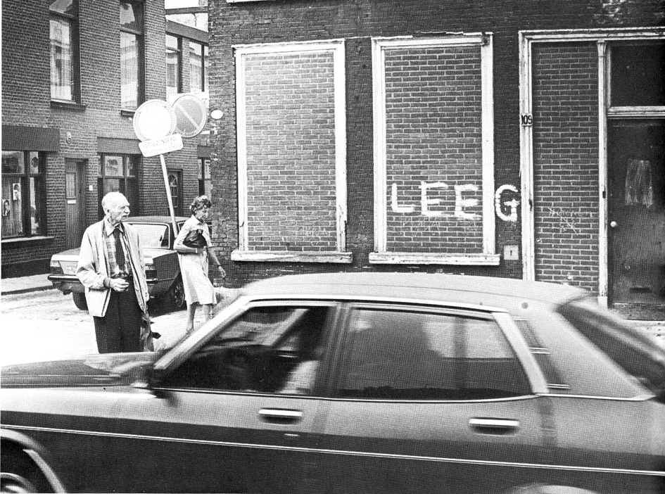
In his lecture, Nuij highlighted the demographic changes in the Schilderswijk. Between 1960 and 1972, there was a nationwide trend of a decrease in the number of residents per household. Urban renewal efforts also led to a decline in the population density per neighborhood. In the case of the Schilderswijk, the number of houses decreased from 15,754 to 14,614 due to expropriation and demolition, representing a 7% reduction. However, the number of inhabitants dropped by 21.6%. Nuij speculated that part of this decline could be attributed to the fact that large, impoverished families resided in the demolished homes. The reclaimed space from demolished houses did not always contribute positively to the neighborhood’s quality of life. Instead of creating playgrounds or green areas, the newly available space was often converted into parking lots, a decision made by the residents themselves. Nuij lamented this transformation, stating, “Here, too, the “tin” [cars] has taken away public space from people” (Nuij, 1973: 5).
Nuij observed that the Schilderswijk lacked a distinct identity, with little cohesion and a diverse mix of ethnic groups residing alongside each other. The neighborhood experienced significant migration, with residents frequently moving in and out. The composition and perspectives of neighborhood committees and councils were constantly changing. As early as 1973, Nuij expressed skepticism about participation, noting a prevailing sense of self-interest. The negative perception of the neighborhood had detrimental consequences. Nuij indicated that the stigma associated with being a Schilderswijker, characterized by assumptions of being less social or anti-social, could impact residents’ opportunities, whether in job applications or seeking housing elsewhere. This perception deeply affected the residents of the Schilderswijk and sometimes fueled their frustrations.
The process of expropriation, demolition of the old city, displacement of original inhabitants, and resettlement in new cauliflower neighborhoods had reached a standstill. The construction of large new social housing units proved to be unaffordable for many low-income families. Immigrants from Mediterranean countries, often with large families, sought the comfort and security of their own community, access to affordable shops, and existing inexpensive housing. Upon their arrival, as they were not immediately eligible for social housing, they turned to the rental market in the Schilderswijk of that period.
A group of seventeen inner-city pastors expressed their concerns about the well-being of the residents of the Schilderswijk. Nuij quoted a letter he received from these pastors, praising the modern initiative led by him and his team. The pastors acknowledged the efforts to construct homes for residents in a style that harmonized with the neighborhood and at affordable rates. They commended the public participation process, noting its international interest. The pastors expressed their admiration for Nuij’s unwavering dedication to this innovative approach, which swiftly reinstated the trust of a significant number of Schilderswijk residents.
The residents of Schilderswijk did not often cooperate with the political changes at the time. In the 1970 council elections, 53% of residents abstained from voting. The neighborhood was also marked by unrest, as boarded-up demolished buildings were set on fire, and the fire brigade attempting to extinguish the fires faced hostility from angry residents. In 1971, the new progressive city council took a significant step by allocating 7 million euros to rehabilitate old houses and make them habitable again. Purchased homes originally slated for demolition were renovated instead. Among the initial renovation projects were ’t Fort and the Van Ostadehofje, designed by the architect Van Liefland. Through these renovations, existing residents and the neighborhood’s spatial structure were acknowledged for the first time, marking a shift towards spatial and historical continuity. Though meetings with residents were reportedly raucous and disorganized, the outcomes were positive. The Dutch neo-Renaissance architecture of ’t Fort was altered with modern insulation and stucco, while the Van Ostadehofje was restored to its original charm. Preserving heritage and repurposing the old charity almshouses proved to be a cost-effective means of providing housing.
Contextualism appears in architecture
Nuij was consistently wary of new buildings that starkly contrasted with its surroundings. He believed that new buildings should harmonize with the existing atmosphere of the neighborhood and the living environment. However, another significant issue arose concerning the construction of new residential complexes, according to Nuij. He emphasized the importance of considering the relationship between the built environment and the individuals for whom it was constructed. “First of all, the question of whether theintroduction of a form of building and living those contrasts strongly with the environment was in line with the new policy, whichwanted to maintain what could be maintained.” (Nuij, 1973: 13) “… or a remediation, once it has been recognized that it is much morethan an urban planning or constructional issue, a social, a human problem, can be carried out without and against the peopleinvolved.” (Nuij, 1973: 13).
Nuij presented three plans as examples of his rehabilitation policy: the De 444 residential complex, the Terniersstraat project, and the redevelopment of the Jacob van Campenplein. The De 444 building plan was particularly significant for Nuij as it showcased the integration of preserving urban morphology and providing affordable rents. The main goals outlined in the objectives document were to ensure that the new construction remained affordable for the majority of Schilderswijk residents and blended harmoniously with the existing surroundings. Another project reflecting Nuij’s policy was the Teniersstraat housing improvement initiative. On July 24, 1972, the municipal council designated 3.5 hectares in Schilderswijk as a test site for neighborhood and housing enhancements. This area was roughly bounded by the Hobbemastraat, Rubensstraat, Mierisstraat, Jan van Goyenstraat, Dijckstraat, with the Teniersstraat running through the middle. Despite efforts, the outcomes of this initiative were deemed disappointing, with reasons for this disappointment remaining unclear (Source: NRC 09-03-1974). Following Nuij’s departure in 1976, alderman Hardon and relevant housing associations proceeded to immediately demolish the renovated houses. Subsequently, a part of the urban renewal projects, Het Klaverblad, and the Tenierplantsoen were established in this area.
The treatment of historical heritage by housing associations and aldermen was not always positive, showcasing a deep-seated aversion toward nineteenth-century neighborhoods. In some cases, the preference for demolishing renovated houses over preserving them indicated a lack of regard for historical preservation, with monetary motives seemingly outweighing other considerations for the housing associations involved.
Another project highlighted by Nuij was the design of Jacob van Campenplein. This project exemplified a conscientious approach to urban planning by preserving twenty-three large trees while integrating twelve small trees and shrubs. The square was purposefully designed with children in mind. The square’s proximity to ’t Fort, the charity courtyard designed by architect Van Liefland, saw a portion of the courtyard renovated with modern insulation and stucco that obscured the original Renaissance architectural details. Another part of ’t Fort was demolished to make way for the new square, reflecting a shifting attitude toward historic preservation in urban development.
Alderman Nuij’s rehabilitation policy for the city extended beyond the concept of building-for-the-neighborhood to encompass building-on-the-neighborhood, emphasizing integration with the existing urban fabric and houses. Nuij believed that strengthening the neighborhood’s identity could address numerous issues without resorting to mass relocation, large-scale demolitions, and new constructions.
This neighborhood-unit approach, common in post-war suburbs, was introduced in the existing city during Nuij’s tenure as alderman. However, his policy was short-lived. By 1974, the old coalition involving Social Democrats, Liberal, and confessional parties was reinstated, leading to the return of Toon van Hagen ‘Teun the Destroyer’ as alderman. This shift allowed large construction companies like Bredero Beton to resume their activities unimpeded. In 1976, Nuij resigned due to health reasons. Conflicts within the city, within his own Social Democratic political party, among his staff, and with the state over proposed policies and distribution strategies may have contributed to his departure.
FAILING URBAN RENEWAL AND CONFLICTS BETWEEN THE COUNCIL AND THE EXECUTIVE
Shift in mentality from the urban planning ideas
Conflicts were inevitable due to the multi-faceted policy with conflicting objectives. In 1974, The Hague saw the return of its traditional representative body consisting of the Social Democrats, Liberals and Christian Democrats after a period with new, inexperienced parties.
However, a fundamental change had occurred with the election of numerous young councilors, known as ’the generation of ’74’. From the Social Democrats, individuals such as Michiel Hardon (1944), ir. Gerard van Otterloo (1950), Joop ten Velden (1945), and Adri Duivesteijn (1950) emerged. J. Verduyn Lunel joined the council representing the processive PPR. Other parties also experienced transformations, with new council members bringing fresh perspectives and innovative ideas. Notable additions included Mrs. H.G. Otter-te-Kolsté representing the Christian Democrats CDA and Mr. Rob W. Heus joining the Liberals (Source: interviews met Gerard van Otterloo 09-11-2010, Joop ten Velden 15-03-2011, Hans van Beek 10-12-2010, Peter Drijver 06-12-2010, Casper Postmaa 02-11-2010 and Joop Bolster 12-01-2011) (HGA BNR 772-1 ‘Werkgroep Dooievaar, 1970-1986’ and Privé Dooievaar-archief of Hans van Beek).
Several council members had backgrounds in urban planning or architecture, leading to an informed understanding of developments in the field and the city. Alderman Nuij retired from politics in 1976 due to heart problems. A division within the Social Democrats faction arose in 1976 regarding the succession of Nuij as the alderman for urban development, with disputes between Hardon and Ten Velden. Ultimately, Hardon was elected but faced criticism from party colleagues Duivesteijn and Ten Velden in the council for the perceived shortcomings in urban renewal efforts. While many discussions and proposed solutions emerged, the policy remained hesitant, despite Hardon’s efforts to address issues.
Following the 1978 elections, Duivesteijn, Ten Velden, and Van Otterloo returned to the council. Hardon resumed his role as alderman, accompanied by party colleague and veteran Vink as the alderman for Housing and Neighborhood Contacts. The alderman for Finance was M.W.M. Vos-van Gortel (VVD), who prioritized municipal budget savings.
Between 1970 and 1980, there was a significant shift in mentality from the urban planning ideas of CIAM, which focused on transforming the old city and suburbanization with the Municipal Development Plan of 1970, to a new focus on the qualities of the existing city and building-for-the-neighborhood. Ambitious journalists, councilors, architects, and urban planners continuously criticized aldermen for policies related to demolition, redevelopment, the construction of a ring road, and the relocation of residents which were perceived to be failing. In 1980, Hardon resigned as alderman, feeling let down and disillusioned by his own party members. The proposed urban renewal efforts had not yielded the expected results, the anticipated inflow of residents had not materialized, and the municipality consistently saved money due to substantial budget cuts by Alderman Vos. As a result, the old city continued to deteriorate, while the council and municipal services clandestinely pursued remediation projects and the inner ring road without clear plans or vision for the city’s future. Tensions between the young council members and the municipality executive reached a breaking point.
Financing urban renewal
The primary dispute revolved around the financing of urban renewal projects. Duivesteijn and Ten Velden argued that The Hague possessed sufficient funds to address urban renewal initiatives (Duivesteijn & Ten Velde, 1980). During Vos’s term as alderman from 1974 to 1981, The Hague consistently generated annual surpluses ranging from 20 to 50 million guilders. Vos’s policy prioritized saving and cutting costs to stimulate economic growth and enhance the living environment, leading to significant divisions within the municipality. The focus on savings ultimately had detrimental consequences for The Hague. When The Hague, alongside other major cities, requested additional financial support from the government due to rising public transport expenses, Amsterdam, Rotterdam, and Utrecht received compensation while The Hague did not. This left the city with a struggling public transport provider, HTM, while Rotterdam and Amsterdam were able to proceed with their metro expansion plans. HTM was predominantly municipally owned, with only 5% privately owned, which further exacerbated the city’s financial challenges. The lack of financial support and limited progress on urban renewal initiatives created an atmosphere of frustration within the council. The consequences of this financial situation lingered, with local politics heavily influenced by the city’s frugal fiscal approach.
According to Van Beuzekom, then director of finance, this was “the trauma of The Hague”, which local politics would follow for a longtime. “In the council there was an atmosphere: we are being punished for our own frugality,” said PvdA councilor J. Bakker in theNRC Handelsblad (Meeus, 1992). Newspapers published statements such as: “Now we have another twenty million left over thisyear,” while the city was devouring and urban renewal had stalled.
The flow of residents
A second point of contention was the discussion around the issue of the flow of residents. In the 1975 Draft Memorandum on Urban Renewal, initiated by councilors Ten Velden and Duivesteijn, they opposed the relocation policy that was common among public housing providers at the time: the relocation of the impoverished population to the suburbs, allowing new residents and businesses to inhabit the city. Another PvdA alderman, Piet Vink, who had extensive experience in public housing, mentioned in an interview that the ‘direct flow of residents’ from the rundown neighborhoods to the new areas was problematic, as people did not move on immediately (Gemeente Den Haag, 1980). The draft memorandum also highlighted that urban renewal involves more than just enhancing housing and spatial structures. “Urban renewal is also, and above all, about improving the living conditions of people in neighborhoods and living environments, where individuals are disadvantaged not only in terms of physical housing but also socially and culturally.” (Kleinegris, 1991: 197). On November 8, 1976, the Memorandum on Urban Renewal in The Hague was approved by the Council, and in June 1977, the Memorandum on Urban Renewal in The Hague – First Follow-up was released. These memorandums indicated that urban renewal was carried out for the benefit of the residents: building-for-the-neighborhood.
The Municipal Development Plan 1970
A third point of contention was the Municipal Development Plan of 1970, with the covert construction of the roads and viaducts through the city as part of the inner ring road, symbolizing the victory of the automobile and the transforming of the city (Duivesteijn & Ten Velde, 1980). Regarding the Prins Bernhard viaduct, new council members Duivesteijn and Ten Velden submitted an initiative proposal. The decision-making power that had been withheld from the municipality council by the executive was thus returned to the council. The discussion in the media became more definitive. The Haagse Courant took an increasingly strong stand against the municipality executive policy and supported the critics. Finally, on June 25, 1979, the city council agreed to a threefold proposal: to study the shortening the viaduct, to have an external agency investigate what urban planning and traffic improvements could be carried out, and to map out the financial consequences. Duivesteijn, Ten Velden, and Dooievaar used photomontages primarily to make municipal policy visible to the population. This was to avoid abstract science, illegible notes, and urban structural plans that nobody understood the consequences of. Dooievaar has awakened the population by visualizing the urban circulation plan and the Municipal Development Plan of 1970. People suddenly saw six-lane highways with viaducts going through their neighborhoods. Perhaps that was the reason why the memorandums and structural visions of the municipality were so sparsely illustrated. Duivesteijn and Ten Velden say: “The Working Group Dooievaar has played a leading role in this protest. Thanks to the fact that this working group visualized the beautiful sentences of the development plan by means of photomontages and drawings, many residents of The Hague woke up.” (Duivesteijn & Ten Velden. 1980: 33). Ten Velden had studied at the Academy of Architecture in Rotterdam and knew the architects of The Hague well. Dooievaar and the new council members also received support from the young Delft professor Carel Weeber and from journalists from the Haagse Courant in their fight against the Prins Bernhard viaduct and the Koekamplus. Increasingly, the battle for the city was waged in the media.
THE REDISCOVERY OF THE LIVABILITY AND THE CITY’S PAST
In the 1970s, The Hague changed from a functionalist city according to CIAM principles, created by specialist to a city that concernedthe entire population and where livability and historicity gave new meaning to the city. From the Gemeentelijke Ontwerp Structuurplan(1970) to ‘building-for-the-neighborhood’. Residents took a central role in neighborhood development, emphasizing building for the community (bouwen-voor-de-buurt). The many incidents between the municipality and citizens that accompanied the demolition of oldbuildings, and the displacement of population were particularly striking. New organizations such as the neighborhood association ‘De Groene Eland’ in the neighborhood Zeeheldenkwartier, Architects’ Working Group ‘Dooievaar’, citizens’ organization ‘Vrienden van Den Haag’ (Friends of The Hague), Municipal Service for Monument Conservation, and the ‘Haags Architecten Café’ (The Hague Architects’Café) made their voices heard in the media, contributing significantly to the shift in mindset towards urban development.
NEIGHBORHOOD ASSOCIATION DE GROENE ELAND
On May 6, 1971, residents were shocked by a loud noise as the municipality embarked on a large-scale operation to cut down thirty monumental Swedish whitebeam trees in Elandstraat. When residents opposed this action, it became evident that the trees were being removed to widen the road profile of Elandstraat for the construction of a ring road. Only a few shopkeepers had been informed about this, while the residents were kept in the dark by the municipality due to anticipated problems. The Zeeheldenkwartier had been denied a zoning plan by the municipality to retain freedom in demolition and restructuring efforts for the inner ring road. The municipality believed that public involvement in planning would only cause concerns among residents. These actions had severe repercussions, and the fight for the neighborhood’s quality of life led to the formation of the residents’ association De Groene Eland.
Various actions were initiated, and signatures were collected. Even the then Minister of Foreign Affairs, Joseph Luns, who resided at Plein 1813, supported the alternative, and added his signature. It was realized that the construction of the ring road would also negatively impact the prestigious Willemspark. Within days, 25,000 signatures were gathered, alarming both the local and national press. As a result, the felling of the Swedish whitebeam trees was temporarily postponed, and consultations with the residents were arranged.
During the anticipation of these consultations, proactive measures were taken. Posters bearing the message that the trees in Elandstraat must be preserved were distributed throughout the neighborhood; one such poster featured a moose with tree branches forming antlers. The unity among residents in the action group De Groene Eland solidified, leading to the establishment of the Residents’ Organization De Groene Eland, which has since been dedicated to enhancing the quality of life in the Zeeheldenkwartier.
Despite collaborative efforts and actions, the discussions with the municipality did not result in the desired outcome, and the Swedish whitebeam trees were eventually cut down. Consequently, Elandstraat became a part of the inner ring road, transforming from a picturesque nineteenth-century street into a bustling highway. For years, freight traffic to the city center congested the area, much to the frustration of the residents.
There was no mention of the proposed demolition of the Zeeheldenkwartier in the numerous memorandums and development plans. The residents’ organization De Groene Eland thrived and, starting in 1974, began publishing the Elandkrant. By the end of that year, they had secured their own building on Piet Heinstraat. Over the following years, residents faced escalating challenges. Following the sacrifice of Elandstraat to traffic, in 1973 there were plans to sacrifice Piet Heinstraat and Witte de Withstraat to alleviate the heavy traffic burden on Elandstraat. Sections of the neighborhood were demolished to make way for a large supermarket Konmar (later Albert Heijn XL) on Elandstraat, exacerbating traffic chaos. The first issue of Elandkrant in 1974 reiterated the ideals of a livable city: ‘A significant number of houses in the Zeeheldenkwartier require improvement, renewal, or even demolition; traffic infrastructure is inadequate at many points or threatens the neighborhood’s quality of life; green spaces and recreational areas are lacking in Zeeheldenkwartier; disruptive businesses are establishing themselves in the neighborhood and shops are vanishing. In essence, living conditions and the residential atmosphere in much of Zeeheldenkwartier need enhancement.’ This newspaper had a circulation of 6,000 copies, was published every two months, and was financially supported by advertisements from many local businesses.
A significant victory was achieved by preventing the demolition of many houses to convert Piet Heinstraat and Witte de Withstraat into a major thoroughfare. An article in the Haagse Courant on May 31, 1974, highlighted that the residents’ organization garnered support from across all political parties, drawing both left-wing and right-wing factions through active lobbying efforts. The battles over various municipal projects were no longer confined to council chambers but were fought on the streets and in the media.
The most notable contrast between the municipality’s vision for the city and how residents perceived it was exemplified by the proposed layout changes to Prins Hendrikplein. Initially, the municipality intended to dismantle this significant enclosed square, allowing tram line 3 to run directly through it. However, following strong protests from the neighborhood, this plan was abandoned, and the tram route was rerouted to encircle the heart of Zeeheldenkwartier in a semicircle.
In 1974, the residents’ association De Groene Eland, in collaboration with Dooievaar, formulated the bicycle route plan for Piet Heinstraat and Witte de Withstraat. Other neighborhoods also expressed interest in extending the cycle route via Weimarstraat to Thorbeckelaan. Additionally, residents advocated for extending the route through Mauritskade, envisioning a safe cycling path connecting one side of the city to the other—an ambitious proposal championed by residents. However, the municipality initially showed reluctance towards the bicycle route plan. As the municipal elections approached, various party programs, as reported in the Haagse Courant on May 31, 1974, started to incorporate discussions about cycling.
Ultimately, these efforts evolved into a pilot plan that was later expanded to cover other neighborhoods. This marked a historic triumph, as it thwarted the municipality’s proposal to transform Piet Heinstraat and Witte de Withstraat into expressways. Instead, Piet Heinstraat and Witte de Withstraat were transformed into car-free streets designated for cyclists.
A notable second victory for residents was the transformation of Tweede Riemersstraat into one of the first residential areas (woonerf). This initiative stemmed from the research conducted by three Delft students three years earlier. While the plan was eventually approved by the council committee at the end of 1975, it was subsequently stalled by certain officials who insisted on conducting a survey among all residents first. Following prolonged back-and-forth, investigations, bureaucratic hurdles, and protests from residents, the residential area was finally established. On June 10, 1977, the area was officially inaugurated in a celebratory event by alderman Wallis de Vries (VVD).
What was once a bustling street with heavy traffic had now been transformed into a green and tranquil space, envisioned as a safe playground for children. However, the increased traffic was redirected to neighboring streets, and later observations revealed that children failed to gain the necessary skills to navigate traffic on the street, thus putting them at greater risk. It became apparent that a residential area did not necessarily provide a real sense of safety.
ARCHITECTS' WORKING GROUP DOOIEVAAR
On Saturday, March 16, 1974, a solemn procession passed through the streets, carrying a portable with a deceased stork, symbolizing the burial of ‘s-Gravehage, as proclaimed by the four bearded bearers from the architects’ working group Dooievaar. This stork had sadly met its demise after being struck by a car at the intersection of Denneweg and Lange Voorhout. The procession made its way to the Haagse Kunstkring at Denneweg 64.
At the Kunstkring, an exhibition was inaugurated showcasing the plans proposed by Dooievaar over the past years in collaboration with neighborhood associations to advocate for restricting cars from residential areas. The exhibition also featured photographs illustrating recent developments in The Hague that the working group deemed as disastrous. The group was initially founded at the Academy of Architecture in Rotterdam during Carel Weeber’s graduation period from 1970-1972. It included members Hans van Beek, Leo Hamer, Jan Ledderhof, and Ary van der Stelt (Source: interviews with Hans van Beek 10-12-2010, Peter Drijver 06-12-2010, Casper Postmaa 02-11-2010 and Joop Bolster 12-01-2011) (HGA BNR 772-1 ‘Werkgroep Dooievaar, 1970-1986’ and Privé Dooievaar-archief van Hans van Beek).
The group’s critique primarily centered on the source of discontent—the Municipal Design Development Plan of 1970 and its CIAM concepts, particularly the implementation of ring roads cutting through the inner city. These initiatives were seen as detrimental to the urban and suburban living environments, with the separation of functions receiving the most criticism. The group believed that the excessive segregation of living, working, and recreational areas necessitated an overreliance on roads and automobiles. The development plan was disparagingly referred to as ‘the Mausoleum for the CIAM’ by the protesting generation.
Dooievaart aimed to diminish car usage and promote public transportation and cycling. Their vision encompassed an abundance of cycle paths, extensive greenery, and a car-free city center. In a press release directed at the Haagse Kunst Kring and the BNA, Dooievaart clarified their mission: ‘Nature of Dooievaar’s work: signaling current urban and traffic engineering phenomena and stressing the importance of involving a broader segment of the population in these matters.’
In a meeting held on June 27, 1972, between Dooievaar and alderman Nuij (PvdA), councilor Van Hagen (PvdA), and chairmen of the local social democrat Mrs. Schilthuis, the following observations, and conclusions from alderman Nuij were documented in the report. “The Municipal Development Plan (1970) will not be presented to the council due to its limited scope, attributing a disproportionate share of traffic to cars, and acknowledging that employment cannot sustain indefinite growth. Accordingly, the Urban Development Department has been tasked with drafting a comprehensive policy document. This memorandum will not only address The Hague’s area but also encompass the city-region’s structure and other relevant aspects.”
There were negative experiences with participation, as it was noted that individuals speaking up did not necessarily represent the neighborhood. Every two weeks, there were different and often highly specific wishes expressed by residents.
Nuij expressed his intention to further discuss this matter in a broader committee to ensure that participation would be handled more effectively and professionally. The absence of zoning plans was also a critical point of discussion, as it effectively left many neighborhoods without proper legal frameworks. This gap allowed administrators to push through undesirable developments without sufficient scrutiny. In essence, Dooievaar emphasized that the population should not be treated as mere subjects but rather as partners in the decision-making process.
In a letter addressed to the city council of The Hague on October 24, 1973, Dooievaar revisited the three contentious memorandums aimed at finalizing the city’s development: the Municipal Development Plan (Ontwerp Structuurplan, 1970), the Exploratory Memorandum on Slow Traffic (Verkennende Nota Langzaam Verkeer, 1972), and the Draft Note on Traffic and Transport Structure of The Hague City Center (Ontwerpnota inzake Verkeers- en Vervoersstructuur Haagse Binnenstad, 1973).
The analysis conducted by Dooievaar highlighted the absence of a clear vision in the notes, emphasizing the need for a preliminary statement of objectives from which a coherent vision could be formulated. In the 1973 draft memorandum, the focus on the number of parking spaces to be created rather than the objectives of the inner city were criticized. Dooievaar proposed that 7,000 parking spaces were sufficient, contrasting with the municipality’s proposal of 9,000 spaces. The freed-up space could then be repurposed for cyclists, pedestrians, and greenery. It was implied that the underlying vision was to maintain the status quo, but the municipality avoided explicitly communicating this to the public. Journalist Jek Kleijn reiterated the core issue:
“What’s it all about? To choose between a city composed of isolated residential islands encircled by highways, where everyone can drive their car but where a healthy social fabric no longer exists. Or opt for a city with a human-centered, adaptable structure that offers experiential value and a sense of belonging yet necessitates restricting car usage. In essence, it’s a decision between having a city worth living in or facing its absence.” (Haagse Courant, September 20, 1974)
It is evident that there was a vision outlined in the memorandums, which Dooievaar and Kleijn disagreed with, leading to the urban challenges faced by the city. In the 1973 draft memorandum, policymakers emphasized narrowing the city focus to the inner city, aligning with the Plan 2000 proposal. The document stated: ‘The center, particularly the core of a city, serves as the central hub of urban life and significantly influences the city’s character.’ This vision depicted a city with a volcano cross-section, featuring a relatively narrow historical core surrounding the Binnenhof, a four-lane inner ring road with grade-separated crossings, and the establishment of a new city developed over parts of the historic city and nineteenth-century neighborhoods. Moreover, the draft memorandum further indicated: ‘The population has chosen to embrace car usage, with car ownership showing a sharp increase… When devising a plan for the city center, this population choice must be considered.’ The practice of civil servants presuming to speak on behalf of the public was emblematic of that era. Additionally, to impede administrative transparency, the municipality artificially inflated reproduction costs for the draft memorandum (1973), raising them to 30 Dutch guilders—despite only involving a few stencils and drawings.
On November 5, 1974, Dooievaar presented the alternative memorandum “Stad? …. Weg Stad”, emphasizing the detrimental impact of car traffic on the city’s quality of life. In their foundational principles, Dooievaar explicitly posed the rhetorical question: should urban planning continue to prioritize cars, or should people reclaim the central focus? Another key aspect addressed was the critical view of the functional segregation approach advocated by the CIAM. There were objections to the city’s compartmentalization into residential (suburbs), commercial (downtown), and recreational areas, which necessitated constant car transportation between them.
Following Nuij’s departure, the 1977 Memorandum on Traffic Settlement in the City Center once again proposed an inner ring road, disregarding the efforts and concerns raised by De Groene Eland, Dooievaar, and the protesting residents. It seemingly ignored their existence and the issues they raised regarding the city’s development.
CIVIL SOCIETY ORGANIZATIONS
As described, the planned demolition of the Kurhaus in 1973 by Zwolsman shook up the entire population of The Hague, and people revolted to save the building from demolition. This time, it was not a matter of hippies or other protesters, but a broad-based resistance in which the historical awareness of the citizens about the city played an important role.
Until now, mainly monuments, townscapes, and village views from before 1850 were protected. In 1971, the Ministry of Welfare, Public Health, and Culture (WVC) designated various parts of the center of The Hague as a nationally protected cityscape, structural plan such as the center within the ring road and the Willemspark. However, the demolition of the city continued, and in 1973 concerned residents of The Hague founded the Friends of The Hague association (Vrienden van Den Haag). The planned demolition of the Kurhaus by Zwolsman was the spark that ignited the powder keg. They wanted to be involved in the development of the city and, above all, to preserve its heritage. The statutes described the objective of the association as: ‘To promote the quality of life in The Hague while retaining its characteristic values.’
The Friends provided numerous unsolicited pieces of advice to the city council, and through publications in newspapers and the association’s magazine, they drew attention to the significance of heritage for the city. In 1974, the Foundation for the Monument Fund of The Hague and the Environment was founded. The main purpose of this foundation was to advocate for the preservation or reconstruction of everything that contributes to the atmosphere in and around the city, the living environment of the inhabitants, and the enrichment of urban and landscape beauty. The foundation focused on preserving special and less profitable monuments.
In 1974, following a motion accepted by the council, the Municipal Executive established a Steering Committee on Monument Policy, led by G.C. Wallis de Vries, alderman for Public Works, Traffic, and Transport. For the Department of Fine Arts, L.J.F. Wijsenbeek and J.J.Th Sillevis were members of the steering committee. The year 1975 was designated as the International Year of the Monument.
In 1976, the Ministry of Culture, Recreation, and Social Work (C.R.M.) announced a new subsidy scheme for the restoration of residential monuments as part of urban renewal plans. That same year, the municipal steering committee developed a memorandum titled View of Cityscape and Monument – Memorandum on The Hague’s Monument Policy (Zicht op Stadsgezicht en Monument – Nota over het Haagse Monumentenbeleid). The memorandum recommended the establishment of a monument office at the municipal level. It delved deep into discussions and objectives for monument policy in The Hague.
During that period, the monument policy conflicted with the public housing policy. While one advocated for preservation, the other favored demolition. The introduction to the memorandum View of Cityscape and Monument further emphasized the importance of not only protected monuments and cityscapes, but also unprotected ones.
In the discussions held in 1976 among the steering committee members, various motives for preserving monuments in The Hague were considered. The key reasons included: citizens’ familiarity with their own environment, neighborhood recognizability and city orientation, as many neighborhoods had distinct characteristics and identities, and the symbolic impact of buildings that contributed to the overall recognizability of the city. This marked an important step as the historical significance of neighborhoods started to play a role, with differences between neighborhoods being identified not only by public housing categories but also based on their historical background.
In January 1977, on the initiative of the Stichting Monumentenfonds Den Haag en Omgeving, a group of influential figures in the city involved in the development of the city center and its monuments established the NV Stadsherstel Den Haag en Omgeving. With financial support from the monument fund, Stadsherstel took charge of the restoration of the city. The establishment of Stadsherstel, led by Mr. Molhuysen, enabled the creation of a professional organization dedicated to addressing a significant workload of neglected monumental buildings in the city center, with the potential for commercial use (https://stadshersteldenhaag.nl).
In October 1977, the Municipal Office for the Preservation of Monuments was established. As early as 1915, the first inventory of monuments in The Hague was created. Initially, it was a list created by the government, called the Provisional List of Dutch Monuments of History and Art (Voorlopige lijst der Nederlandse monumenten van geschiedenis en kunst). These buildings were constructed before 1850. The Hague became one of the first municipalities with its own municipal ordinance and a municipalmonument list on which 235 buildings were listed. By 1961, The Hague had a total of 740 monuments on the government’s list, and by 1987, this number had risen to 760. Following the Second World War, a substantial amount of restoration work was undertaken, primarily focusing on churches and government buildings (Gemeente Den Haag, 1987). In 1980, the first Hague Monument List was compiled. From 1984 onwards, monuments, particularly ensembles of urban planning and architecture that had significance in The Hague’s history, were documented in various publications by Monumentenzorg, inclusive of the well-known VOM book series.
INVENTORIZATION, CATEGORIZATION AND INTERPRETATION: ARCHITECTURAL MONUMENTS
The information service in The Hague also began to pay close attention to the historical significance of the city. In the 1976 municipal publication appropriately titled Den Haag Stad om te Blijven (The Hague City to Stay), the writer acknowledged the growing interest in historicity but highlighted the challenge of a diminishing center area with historical monuments and the extensive remediation (Gemeente Den Haag, 1976). The writer expressed a sense of irony in the situation, considering The Hague’s age and history, stating, ‘It’s crazy, with such an ancient city as The Hague. On one hand, there’s a longing for the old, for the historical. An increased interest in everything that reflects a grand past. But beyond that historical core, the term ‘historic’ isn’t applied to the ‘old’ neighborhoods. Instead, ideas of renovation, urban renewal, and rehabilitation come into play.’ At the same time, there was an exodus of citizens out of the city.
In addition to the interest in preserving historical monuments, there was also a growing appreciation for the everyday city life of the past. The photo book Den Haag en Omstreken in 19de-eeuwse Foto’s (The Hague and its surroundings in 19th-century photographs) from 1975 by Nieuwenhuijzen and Slechte in 1975 offered a different perspective of the cityscape compared to previous publications (Nieuwenhuijzen & Slechte, 1975). Alongside images of monuments, the book featured numerous photographs of working-class neighborhoods, people in modest attire, and decaying seventeenth-century houses, often captured by unknown photographers. The photo book concluded with a lengthy essay by C.H. Slechte, vividly describing the challenges and struggles of the nineteenth-century city built on peat bogs. This publication provided a valuable glimpse into the everyday lives and living conditions of the past, offering a more comprehensive view of The Hague’s history beyond its grand monuments.
The book Den Haag – Over bouwen, breken en behouden (The Hague – About building, demolishing, and preserving) from 1976 presented a contrasting cityscape as well (Mast & Rijven, 1976). Authored by Michiel van der Mast, who was employed at the municipal museum in The Hague, the book raised the crucial question of whether achieving the right balance between construction, demolition, and preservation could ultimately enhance the quality of life in The Hague. This publication marked the first time such significant queries were addressed in a government-related work. Although not directly produced by the municipality itself, the Department of Urban Development in The Hague, the Municipal Archives, and the Gemeentemuseum collaborated enthusiastically on this book in support of the passionate civil servant. The book shed light on the city’s evolving landscape and brought attention to the intricate interplay between building anew, tearing down, and conserving historical elements for a sustainable urban environment.
The book Bouwen op Haagse Gronden (Building on The Hague Grounds) from 1981 which detailed the history of the municipal contractor HABO, provided Frank Smit with a comprehensive overview of urban planning policy from the interwar period onwards, in relation to local politics. Drees, who was involved as an alderman in the establishment of the HABO, wrote the foreword (Leeuw-Roord et al., 1981).
In 1988, the first comprehensive architectural guide of The Hague was published under the title Architectuurgids Den Haag 1800-1940 (Architecture Guide The Hague 1800-1940). The guide was compiled by employees of the newly established Municipal Office for Monument Preservation, including Drs. H.P.R. Rosenberg, Drs. Christiaan Vailliant, and Drs. Dick Valentijn. Kees Stal from the The Hague Municipal Archives contributed data on architects and construction years. This guide became a foundational reference work for numerous publications in the 1990s. The monuments were described within their historical and spatial contexts, providing valuable insights into the architectural heritage of The Hague.
Kees Stal of the The Hague Municipal Archives also commented in the trilingual book Den Haag: Beelden van Toen & Nu (The Hague – Images of Then & Now) from 1992 that, as he points out, ‘All in all, the changes that the cityscape has undergone in the last hundred years have brought about nothing less than a visual revolution. High-speed traffic, large-scale modern technology, and urbanization have rapidly transformed what had been developed over centuries in what appeared to be a gradual, almost organic growth process: a revolution in a The Hague that seemed to lead a calm and static existence a hundred years ago.’ (Stal & Spaans, 1992).
THE HAGUE PROTECTED CITYSCAPES
It wasn’t until 1996 that eight neighborhoods in The Hague were designated as a National Protected Cityscape. These neighborhoods were laid out between 1850 and 1940 and include Van Stolkpark, Statenkwartier, Duinoord, Archipelbuurt, Zorgvliet, Westbroekpark, Benoordenhout, and Marlot. The designation of these neighborhoods took place in 1993 based on an inventory conducted by the Municipal Bureau for Monument Care.
The release of the Notitie Monumentenzorg 1995-2005: zicht op stadsgezicht en monument 3, 1995 (Memorandum on the Preservation of Monuments 1995-2005: focusing on cityscape and monuments 3) introduced a new approach to preservation. This pioneering initiative positioned The Hague ahead of other cities in the Netherlands, as noted by Schmidt in 1996. Lankamp, representing monument conservation, argued that protecting a cityscape was not a choice but came with inherent obligations.
‘The most significant obligation is ensuring that the zoning plan for the protected cityscape effectively safeguards the values outlined in the designation decision. Currently, the zoning plans for the eight neighborhoods are already conservative, with only minor adjustments needed. Furthermore, according to the Monuments Act, any demolition within a protected cityscape necessitates a permit. This requirement ensures that the impact of proposed demolition on the neighborhoods value is carefully assessed’ (Schmidt, 1996).
Since then, neighborhoods and neighborhoods have been distinguished by their unique characters based on historic buildings and urban spaces. Starting from the 1980s, terms like ‘cityscape’ and ‘neighborhood character’ became common in municipal documents and publications, whereas prior to 1970, these terms were seldom found. From 1988 onwards, the historical context of a neighborhood became the foundation for heritage descriptions, as highlighted by works by Rosenberg et al. (1988), Freijser et al. (1991), Hoeve et al. (1992), Koopmans (1994), and Boven et al. (1997).
The architectural historians of monument preservation expressed in their justification: ‘An architectural-historical and urban planning introduction precedes the section where the buildings are described neighborhood-by-neighborhood. Each neighborhood is provided with a brief history and characteristics introduction, followed by descriptions of individual buildings’ (Rosenberg et al., 1988).
This line was eventually implemented in Den Haag 2000 monumenten – Haags Monumenteninformatiesysteem (Gemeente Den Haag, 1999), the Welstandsnota (Gemeente Den Haag, 2004) and the handy PPW – Praktijk Pocket Welstand (Gemeente Den Haag, 2004).
In the period following 2010, reflections on the city shifted towards isolating heritage from its urban context and organizing it chronologically on a timeline, likened to a collection of disconnected milk jugs. Between 1980 and 2005, there was a strong historical consciousness regarding urban ensembles, particularly neighborhoods.
The collective efforts of various neighborhood associations, architectural working groups, and enthusiasts of architecture and history played a pivotal role in pushing The Hague past a tipping point during these years. Consequently, this marked the end of an era characterized by extensive CIAM urban development projects and the construction of major ring roads, signaling a shift towards a more balanced and heritage-conscious urban development approach.
THEMING OF THE CITY: LILLINGTON STREET HOUSING COMPETITION
A NEW WAY
The changes that offered residents a perspective did not only come from politics but were made possible by developments within the professional disciplines of urban planning and architecture.
Sometime in the early 1970s, The Hague architect Schamhart and alderman Nuij visited Lillington Gardens Estate of Street Housing in London, in the Pimlico neighborhood of Westminster. It was a newly completed residential ensemble between Vauxhall Bridge Road and Tachbrook Street. Lillington Gardens in London was a model project for the architects from The Hague and for Nuij for Couperusduin, according to the architect Hans van Beek in an interview on December 10, 2010. The Lillington Street Housing Competition was won in 1961 by the architect John Darbourne and was carried out by Darbourne and Geoffrey Darke between 1964 and 1971.
The project consists of several buildings and half open urban blocks that enclose a few green courtyards. It has a clear urban front on the street side and a softer interior with greenery. This urban ensemble brings together several qualities that would later become important in city building: diversity as found in old cities, high housing density, variation in shapes, coherence of urban space with buildings, materials that support urbanity such as brick, and a variety of entrances and passages. The urban ensemble was integrated into the morphology of the urban landscape, but the buildings that once stood there have not been preserved. There are no historical references in the austere brick architecture.
Hans van Beek, who worked on Couperusduin, cited Lillington as an example. Characteristics of Lillington can be found in projects such as Couperusduin, the Markthof, and Oranjeplein, as well as in other super urban blocks. However, due to a lack of funding and legislation preventing the integration of social housing with other functions, these ideas were not always executed with the same level of richness. Lillington’s concepts could also be observed in the layout of new residential neighborhoods.
An example of this is seen in the development of the De Nieuwe Hout residential area (Bezuidenhout West), situated between Utrechtsebaan, the railway, Schenk viaduct, and Prince Bernhard viaduct. At a council meeting, a book with photos of it was reviewed, as stated by former council member Joop ten Velden in an interview on March 3, 2011, and Gerard van Otterloo on November 9, 2010. Ten Velden had studied at the Rotterdam Academy in Rotterdam from 1967-73 alongside architects from De Dooievaar. After his studies, he worked at the PPD (Provinciale Planologische Dienst of Zuid-Holland) under Niek de Boer in The Hague. Van Otterloo studied in Delft at the Department of Urban Planning under Professor Niek de Boer.
One of Lillington’s themes is the informal in-between paths, corridors, and shortcuts. These can also be found at Couperusduin, ZHB-Hoven, Markthof, and Oranjeplein. This theme also took on a new meaning in the city center. The shopping arcade with refined urban spaces meandering between old buildings and the shortcuts came to attention with Lillington Street Housing, in addition to the study by Jane Jacobs (1961), which gained great popularity with Niek de Boer’s PPD, according to Ten Velden and Van Otterloo.
Entrepreneurs saw opportunities, and several passages were built in the old center or even reinstated. In addition to the monumental Haagse Passage from 1885, The Hague also had the Vroom and Dreesman passage between Spuistraat and Grote Markstraat. In the interwar period, this was still a fresh, modern passageway with lots of glass and crisp shop windows. Around 1974, the Queens-Passage was completed, connecting Hoogstraat with Paapstraat and Annastraat. There was also a passage connecting Hoogstraat with Buitenhof, the Pander-Passage on the corner of Vlamingstraat and Waagstraat near Weversplaats, built around 1972. The Markthof-Passage connected Gedempte Gracht with Grote Marktstraat and was fully operational by 1972. The Pasadena-Passage connected Waagstraat with Groenmarkt and was located where Haagse Bluf is now situated. The passage was opened, and part of Haagse Bluf was added. Markthof also had a passage meandering through the building, connecting streets. The Babylon shopping center next to the train station, designed by the architectural firm Lucas and Ellerman, was given a passage, but that was one of the last passages built in The Hague.
DRAFT MEMORANDUM ON URBAN RENEWAL 1975
Another theme is the complete disappearance of existing buildings and street patterns within the building lines, replaced by a new ensemble of urban blocks, strips, and hooks around or near green spaces. In the 1975 Ontwerpnota Stadsvernieuwing in Den Haag(Draft Memorandum on Urban Renewal) in The Hague, the young councilors Adri Duivesteijn and Joop ten Velden are crystal clear about the approach to urban renewal, as well as about what is meant by the appalling quality in the old neighborhoods
- Long, straight, narrow streets with densely packed buildings.
- Green spaces are almost entirely lacking.
- Playgrounds for children are scarce.
- Courtyards are filled with extensions and small businesses.
- Cars occupy almost the entire street, leaving narrow lanes and walkways.
- Certain forms of socio-cultural, medical, and educational facilities are underrepresented in working-class neighborhoods.
- Much more often than in other residential areas, there are companies such as warehouses, junkyards, rag shops, and the like, which may add some liveliness but often cause nuisances and do not improve the quality of the living environment.
TEAM X, NATIONALE STICHTING NIEUWE WOONVORMEN AND STICHTING ARCHITECTENRESEARCH
Already in a manifesto presented at the Congress of Otterlo in 1959, Aldo van Eyck and the members of Team X declared that CIAM was dead (Heuvel, 1992). Out of this movement developed structuralism, with the concept of support-and-infill (drager-inbouw-concept).
In 1968, the Nationale Stichting Nieuwe Woonvormen (National Foundation for New Forms of Housing) was founded. Government, architects, housing associations, consultants, and contractors united to demonstrate that a different way of building could be realized without significant rent increases.
It was a critique of the large-scale flats that had been built. The Dutch variant of structuralism was criticized as new clumsiness by Komrij and Weeber. Little came of structuralism and the support-and-infill-concept. The differences between the architects were also considerable.
The starting points of the new ideas were: (a) High housing density (50 dwellings/ha instead of the average 25); (b) Integration of living, working, and recreation; (c) Priority for pedestrians and cyclists; (d) Reducing the presence of cars to the outskirts of the neighborhood; (e) Paying close attention to the local characteristics of the environment.
At the end of 1971, the first experimental and subsidized project started in Berkel en Rodenrijs. The architects were W. Brinkman, J. Verhoeven, H. Klunder, and N. Witstok. The residential area of 535 social housing units was completed in 1972. Another foundation that emerged during these years was the Stichting Experimentele Woonvormen (Foundation for Experimental Housing Forms), later reformed to: Stuurgroep Experimenten Volkshuisvesting SEV (Steering Committee for Experiments in Public Housing SEV).
John Habraken developed and promoted the support-and-infill concept in his book De dragers en de mensen (The Carriers and the People) (1961), as an alternative to mass housing in the Netherlands. This concept allowed individual residents space for individuality and self-expression while making optimal use of production techniques to keep rents low.
The Stichting Architecten Research (Foundation for Architectural Research) (SAR 1964-1976) was established to further investigate and develop these ideas. However, there were challenges with the base installation experiment, and the public housing machine turned out to be more difficult to manage. The ideas of support-and-infill faced obstacles from regulations and guidelines, hindering innovation.
THE MODULAR DWELLING UNIT IN RESIDENTIAL DESIGN
Noud de Vreeze (1990) depicted a staggering image of the extensive interference in housing plans by the national government. Between 1955 and 1975, officials implemented stringent regulations, effectively freezing housing plans. Rents were tied to these floor plans, and every attempt at innovation was thwarted with legislation. Initiatives for small homes for the elderly, student housing, or larger residences were stifled. What was intended as a minimum requirement for room size, as outlined in the Voorschriften en Wenken(Regulations and Guidelines), was effectively treated as a maximum to keep rents low. Additionals such as dormer windows, slightly larger outdoor spaces, or more spacious bathrooms were discouraged as unnecessary luxuries and rejected by assessing officials.
For Minister Schut, this served as an argument for reforming the housing market, including changes to housing subsidies and legislation. In the early 1970s, a new system emerged: the Normkostensysteem (NKS) (Standard Cost System), aimed at financing housing construction and promoting traffic flow. Under this system, subsidies were allocated based on the number of square meters of living space, irrespective of foundation costs. Foundation cost overruns, such as those due to challenging building sites or limited space, were not factored into the rent. This facilitated the construction of houses within existing urban areas, even with added demolition costs. However, this approach led to limitations in housing diversity. Ultimately, only 100% three- and four-room houses with a living area of 70m2 were constructed. The exact standard on which costs and rent were based became increasingly unclear over time.
After 1975, standards were dictated by the Model Bouw Verordening (MBV) (Model Building Ordinance). Once again, the lower limits of the standards became the upper limits of achievement, marking a new tragic low. De Vreeze observed that, ‘This led to constant pressure on architectural and urban quality, without the NKS formally enforcing it, driven by client’s efforts to achieve affordable rents’ (De Vreeze, 1990: 25). Forced by regulations, the modular dwelling unit – a cluster of houses around a portico repeated endlessly – became the norm for affordable housing. Many residential architects were compelled to adopt this model out of necessity. They had to adapt a floor plan frozen by regulations into various configurations that fit within the urban plot. Often, there was little budget for a beautiful facade or livable outdoor space, as rents had to be kept low.
Large residential complexes with super urban blocks typically comprised a combination of residential buildings around or near new green spaces. The buildings formed a succession of modular dwelling units, and affordable housing was constructed in large flows within the morphology of the existing city. However, the old city, including old street patterns and buildings within the building lines, was almost completely wiped out in favor of the new planning.
THE SUPER URBAN BLOCKS OF THE HAGUE'S URBAN RENEWAL
The cases provide an overview of the origins and character of the new type of super urban block. It begins with the urban blocks of the Schilderswijk, including ‘The 444’ (1973-1976). Then, it mentions two iconic housing complexes: ‘Couperusduin’ (1972-1975) in the Archipelbuurt by Sjoerd Schamhart and Hans van Beek (later transformed into atelier PRO architekten), and ‘ZHB-Hoven’ (1975-1981) in Kortenbos by Henk Klunder. Other notable projects include the residential complex with offices and shops, ‘De Markthof’ (Gedempte Gracht, 1975-1978), designed by Verhave, Luyt, and De Iongh (successors of Dirk Roosenburg who started in 1919, later LIAG architects and building consultants). Additionally, there’s the residential complex with shops, ‘De 222’, located in the Frederikstraat (Archipelbuurt, 1976-?), designed by Group 5 Architects and Urban Planners (Edsard Luursema, Van de Linden, Bram van Hengel, Dick Koersen). ‘The Schipperskwartier’ residential area (Laakhavens, 1980-1985) by Andries van Wijngaarden and the ‘De Nieuwe Hout’ residential area (Bezuidenhout-West, 1978-?), designed by Group 5 Architects and Urban Planners (Bram van Hengel and Wladimir Roemjantsev), were also significant projects.
These projects were important exemplary endeavors by aldermen, showcasing the quality of life and positioning The Hague as an attractive place to live. They served as effective political tools to garner support from voters, as everyone could see how bad andneglected the old city was.