
Cityscape of Fin de Siècle 1890-1905
‘überall Schema, keine Eigenart’ Josef Stübben, Der Städtebau (1890)
The call for beautification and urban amenities with the Liberal Union
Lindo and Van Liefland and the experience of modern times and space

The contrast could not be greater with the previous cityscape. The cityscape of the fin de siècle would produce picturesque neighborhoods like villages with a diversity of buildings full of ‘Eigenart’ within the ‘Schedule’ of wider streets with the first cars and trams. A feast of materials, colors and shapes, for squares and through streets, make these residential areas very popular. Fin de siècle means in French for the end of the century. If one sees a turret on a house somewhere, it is usually a fin de siècle district where individuality was noisily celebrated. The neutral village in the leafy greenery with its actual village character with the new housing estates was given a new layer with great image quality. Due to the way of urban interpretation with building-land-companies, new residential areas were mainly built within the network of main roads, which further strengthened the village character. The cityscape of the fin de siècle was made possible by advancing industrialization and profound social changes. The political climate after 1890 changed and prosperity increased among a large part of the bourgeoisie. Individual expression and experiential value were central to The Hague until 1910. The call for quality such as diversity, individuality and hygiene in the city resonated with the Liberal Union with affordable technical facilities implemented by a completely new service. A new architecture and new social values.
A number of legislative changes accelerated the arrival of this cityscape. The Netherlands received the first Patent Act (Octrooiwet) in 1817, but this law was abolished in 1869. This law was considered too restrictive. In 1883, 140 countries agreed on patents, trademarks and designs in the Paris Union. An inventor had the right to apply for a patent within 12 months. It would take until 1910 before a National Patent Act was passed. So, there was no good legislation on the patent during this period, which gave a lot of freedom to developments.
The Liberal Union also abolished the patent law tax system (Patentrecht) in 1884. That was a professional tax, a precursor to corporate tax. This gave one the right or license to carry out a business or profession. In 1813 the Right to Patent was introduced. After the constitutional revision of 1887, a much broader faction of middle-class men was allowed to vote. The Census suffrage 1849-1887 was transformed into Universal Suffrage. All men who owned or tenant a house with a rental value above a certain minimum were now allowed to vote. As a result, the Liberal Union became the main party. In the city council, the interests shifted and that was also reflected in the city’s facilities, which were being implemented at a rapid pace. The abolition of patent law and the absence of patent legislation started a true revolution in building materials and construction techniques. These legislative changes had a major impact on society.
They also looked at the world from a whole new perspective. The fin de siècle was accompanied by a change in the experience of time and space. Albert Einstein’s 1905 special theory of relativity did not stand alone. There was a huge technological development. In this period, with a new mobility and infrastructure works, telegraph and telephone, the experience of space became different. Naturally inspired by examples from the major European metropolises. The space itself was reduced because people were in another city faster than ever with the new mobility that developed during the second half of the nineteenth century such as train, steam tram and later electric tram, the first cars. In other cities one saw historic architecture that one also recognized in one’s own city.
Who were the important people in this cityscape? Diversity and individuality were seen as beauty and quality. While Lindo had an eye for beauty and quality, Van Liefland had an eye for urban planning, technology and politics (he was also a council member). While Lindo, in his expansion plan in 1903, was accused of not having an understanding of beauty. Both found each other in different plans such as those for the Transvaalkwartier and the Bezuidenhout, and in the breakthroughs in the city center where they preferred the picturesqueness of crooked streets to the straight boulevards of Halbersma and eighteen years later Berlage and alderman Lely.
The quote from the German urban planner Josef Stübben (1845-1936) from 1890: ‘überall Schema, keine Eigenart’, in which traffic circulation played an important role and the diversity of buildings arose naturally due to all the small initiatives, was music to the ears of the progressive liberal Lindo and architects such as Van Liefland. The same applied to the pleas of the Viennese urban planner Camillo Sitte (1843-1903) for the experience of urban spaces such as in the picturesque medieval cities with a diversity in buildings and enclosed urban spaces (Sitte, 1889) (Reiteren, 2003). The Hague aldermen of the Liberal Union, such as Jacob Simons (1845-1921), also Dr.ir. Cornelis Lely (1854-1929) and Jurriaan Jurriaan Kok (1861-1919), administrators who also played an important role in the creation of the Housing Act (1902) and the Berlage Expansion Plan (1908), considered quality, diversity and individuality important.
The seaside resort was the most iconic urban ensemble. European-oriented architects such as Van Liefland and the firm Mutters (which would carry out the ship carpentry for the Titanic) gained name and fame during the substantial expansion in the seaside resort from 1893 to 1904 under the visionary leadership of Bernhard Goldbeck (1844-1921) of the Maatschappij Zeebad Scheveningen (M.Z.S.). The plan that Van Liefland made in 1902 for the seaside resort was a novelty. The hotels, the walking head, the promenade along the beach, the circus theater and other buildings were meticulously mapped out and all available building plots were clearly visible. Just before the great Second Peace Conference in 1907, this was an attractive urban ensemble to invest in. The painter Sommer produced two enormous panoramas of Van Liefland’s plan for the management of the Exploitatie Maatschappij Scheveningen (E.M.S.), the successor of the M.Z.S. The seaside resort would prove invaluable and a catalyst in the development of the new cityscape. It attracted many wealthy new citizens who settled in the residential parks.
The city center also went through a stormy development. Everywhere, old facades were demolished and replaced by huge glass fronts supported by ornately curved wood and cast iron. The Hague turned into a real service city with ministries, offices and luxury warehouses and shops with open glass facades. Around the Piet Heinstraat, Hoogstraat, Wagenstraat and Spuistraat many beautiful shops appeared with fin de siècle facades.
The cityscape also found its way into the new residential areas. The historical consciousness with neo-Renaissance architecture was not forgotten either. Neighborhoods such as Duinoord and the Statenkwartier with the beautiful avenues and beautiful squares with richly decorated houses were iconic urban ensembles for The Hague. For example:
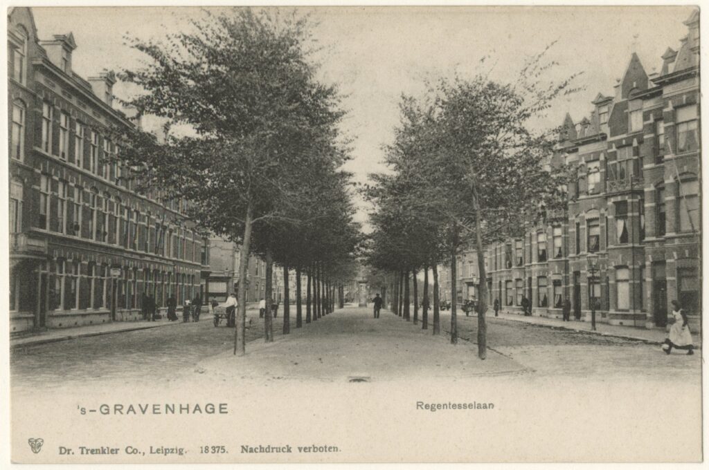
- Regentessekwartier (Regentesselaan);
- Duinoord & Groot Hertoginnelaan;
- Transvaalkwartier (Paul Krugerlaan, Schalkburgerstraat);
- Statenkwartier (Statenlaan, Stadhouderslaan, Eisenhouwerlaan, Willem de Zwijgerlaan, Frederik Hendriklaan);
- Valkenboskwartier (Valkenboslaan);
- Schilderswijk Zuidwest (Vailliantlaan, Van der Vennestraat, Ruijsdaelstraat, Wouwermanstraat, Zusterstraat);
- Bezuidenhout (Juliana van Stolberglaan, Louise de Colignystraat, Stuyvesantstraat);
- Benoordenhout (Bilderstraat);
- Belgisch Park (Amsterdamsestraat, Middelburgsestraat);
- Renbaankwartier (Renbaanstraat).
Between 1890 and 1910, turrets of all shapes and sizes appeared everywhere on residential houses and retail warehouses, The Hague truly became a turret city. Internationally oriented clients and owners of building land companies made this urban development possible. The Hague land trader and building contractor dr.mr. Adriaan Eliza Herman Goekoop (1859-1914) and The Hague banker and entrepreneur Dr. Daniël François Scheurleer (1855-1927) supported cultural life and saw that quality was a necessity to interest new residents in buying a house in one of their new neighborhoods. These fin de siècle districts consisted of a system of continuous closed urban spaces with a wide variety of small-scale buildings of mostly three to four floors. No closed building blocks but open corners for daylight and ventilation, no homes in courtyards. The separate and more expensive houses on main roads and squares were given individuality. Houses were usually built by construction companies in series of two to ten pieces.
This cityscape has clear characteristics. In experience of modern times and space, various aspects played an important role. These aspects became the characteristics for these urban ensembles of Lindo, Van Liefland, Scheurleer and Goekoop, among others:
- Mobility facilitated with a traffic circulation with continuous system of main streets, roads and rails;
- Hygiene through utilities, light and air for the houses with open building blocks;
- Diversity in buildings due to different angles between streets;
- Individualization of more expensive homes on main streets and squares;
- Closed urban space due to kinks, curvatures, dead ends of streets, constrictions at the beginning and end of residential streets;
- Greenery in urban spaces (such as central strips with shell pavement and double rows of trees near the main streets and front gardens in the residential
The cityscape of the fin de siècle is the most complex and the most elusive, but one with a huge influence on The Hague. There is no fixed body of thought that can be referred to, rather it is a tough undercurrent. It has no unambiguous form and no discourse. The cityscape of the fin de siècle did acquire its own character that distinguished itself sharply from the period before 1890 and after 1910. On the basis of the building plans, the conflicts and especially the circumstances, the cityscape of Lindo and Van Liefland cum suis can be reconstructed. The Hague distinguished itself from other cities of this period and thus acquired a distinct individuality.
During the fin de siècle, the experience of the individual in the fields of urban planning (Sitte, 1889) and housing became important. When designing urban spaces, it was preferable to look through the eye of the space users instead of applying an abstract grid. Serial homes were given their own expression or at least their own front door. From 1890 it mattered what a city or a house looked like and this became a task for the urban planner and architect who shaped it, just like with the picturesque Van Stolkpark.
Aestheticization, historicization, individualization and Universal Suffrage
The Liberal Union is one of the most important institutions, played an important role and dominated the House of Representatives and the Council of The Hague. In the cabinet of social liberal Nicolaas Gerard Pierson (1891-94), between 1892 and 1893, the tax system was radically reformed from a system based on paying taxes on goods to a system that was also based on taxes on wealth and taxes on income from business and profession. Also, as previously reported, patent law and patent law came to an end. As a result, economic development was stimulated considerably and industrialization kicked into high gear with major consequences for the building culture. The change in the tax system gave the state and the municipalities more financial opportunities (Smit 2002). The deplorable state finances in 1840 were no longer in question around 1900. It put an end to the financial animosity between the provinces and reduced the political and social divisions, because the tax received many more taxpayers after the reforms (Smit, 2002).
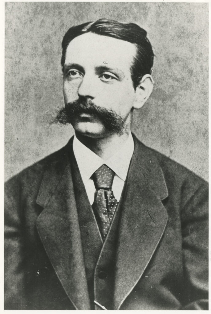
The Department of Municipal Works grew into an important institution that shaped the lay out of the infrastructure. Together with large investments by bankers Goekoop and Scheurleer such as at the seaside resort and the new residential areas. Lindo was the right man in the right place. He had the political tide with him, because the progressive Liberal Union wanted to get rid of laissez-faire. After the reorganization of the Department of Municipal Works in 1890 and the arrival of the first director architect Isaac Anne Lindo (1848-1941), the lay out of urban ensembles was professionally taken care of by architects and engineers.
Lindo was a versatile engineer with experience in the field of waterworks, trams, roads and street plans. In Arnhem he had shown that he had an eye for urban beauty and the new ideas in the field of urban planning and hygiene. Engineers worked at a rapid pace on urban facilities such as sewers, utilities, streets, streetcars and waterworks. In 1905, the civil engineer Pieter Bakker Schut (1877-1952) would be hired by Lindo to take care of the electrification and lay out of the tram network. As early as 1907, Bakker Schut was promoted to Ingenieur-Afdeelingschef. From 1891 onwards, architects of municipal works such as Adam Schadee (1862-1937) built schools, police and fire stations, bathhouses, wash houses, slaughterhouses and buildings for the utilities such as the gas factory and the electricity works on a large scale.
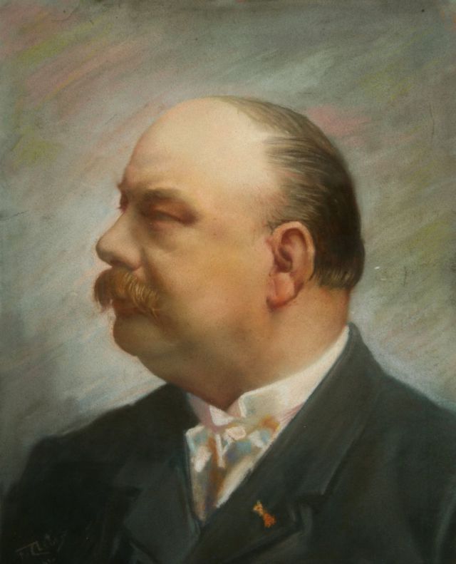
Other architects such as Bernhard van Liefland (1857-1919) brought the new architecture and taste from London, Paris and Vienna to The Hague and renovated Scheveningen Bad. The East Indies also attracted the attention of architects, residents and shopkeepers and beautiful tile panels, onion towers and horseshoe arches appeared everywhere on houses and at shops. All these entrepreneurs, architects, engineers knew each other and worked together on the city.
Bourgeois culture broadened with the attention to history, individualization and aestheticization in this heyday (Bank & Buuren, 2000). The literary movement such as De Tachtigers (ca.1880-94) and the painters of the Hague School proclaimed a new art with impressionism and naturalism. In The Hague, the internationally oriented Berlage and the journalist Johan Gram (1833-1914) had been fulminating against the monotony of the neighborhoods for some time (Gram, 1893, 1906). For Berlage this was an outgrowth of individualism and lack of direction by the municipality, for Gram the boring construction company houses that were built everywhere. The artistic and intellectual milieu of The Hague was concentrated around a number of institutions and persons of prestige and influence, often also the persons who were directly involved in the lay out of the neighborhoods and the buildings. A lot of preliminary work had already been done by artists of the Hague School from 1847 in the Pulchri Studio, especially under the chairmanship of banker and painter Mesdag.
For example, the Historical Society Die Haghe (Geschiedkundige Vereniging Die Haghe), which was founded in 1890, united The Hague’s cultural elite of bankers, entrepreneurs, administrators, journalists, architects and civil servants. Honorary members included Gram, Baron Snouckaert, Scheurleer, Goekoop, De Stuers, Israëls and Mesdag. On the board were Goekoop and Gram. Van Liefland, Molenaar, Mutters, Van Nieukerken and Simons were also mentioned as working members in 1898. The architect Wesstra was also a member, as an extraordinary member were also called the banker Penn and De Sonnaville. These were almost all the people in The Hague who were involved in the seaside resort, the lay out of neighborhoods and the buildings between 1890 and 1910. These individuals concentrated power, money, land, influence, and vision. The society had the Grand Duchess of Saxony, Princess Sophie of the Netherlands and the Queen Regent Emma as main donors. Article 1 of the association’s statutes, when it was founded on 15 December 1890, read: ’to get to know and know the history of The Hague from the sources.’
A year later in 1891, another important association was founded: The Hague Art Circle (De Haagse Kunstkring). Initially, the art circle was a movement around Jan Toorop (1858-1928), Johan Thorn Prikker (1868-1932) and his Arts & Craftswinkel on the Kneuterdijk and Henry van der Velde (1863-1957) who brought Art Nouveau, Jugendstil, Wiener Secession and the new art to The Hague. Jan Toorop organized the first retrospective of Van Gogh in 1892. The differences between the camps within the art circle grew larger and larger over the years and the movement gradually politicized itself with Berlage and Wils. Architect members were: Cuypers, Berlage, Wils, Brandes, De Bazel, Wijdeveld, Van der Kloot Meyburg, Wegenrif, Broese van Groenou, De Clercq, Gratama, Stuyt, Jurriaan Kok and Bakker Schut. In 1923 Kurt Schwitters and Theo van Doesburg held the first Dada meeting in the Netherlands in the The Hague art circle.
With Pulchri Studio, Geschiedkundige Vereniging Die Haghe and De Haagse Kunstkring, all the main players who contributed to the aestheticization, historicization and individualization of the city are together. The cityscape of the fin de siècle was self-evident to them. The previous period seemed completely forgotten.
Changes to the inner city and the new residential areas
After 1870, the civil and workers’ quarters described above started the process of phenomena that would later be referred to as ‘suburbanization’ and ‘city formation’. City formation, a term Gram already used, is a complex process. As described earlier, the old dark residential city with its smelly canals turned into an illuminated service city with ministries, restaurants, beautiful warehouses, bazaars, shops like lanterns and walking areas with shell pavement and lime trees in the places of the muffled canals. The sweet-smelling linden blossom had softened the malodorous scent of the canals in the summer.
Around 1870, the population within the canals reached a maximum of more than 60,000, about 65% of the population, then the population in the center decreased. In 1880 there were still 56,000 inhabitants. In 1900 the city center still had 55,000 inhabitants and in 1910 only 52,000 inhabitants, 11 to 12% of the population disappeared from the old center (Bakker Schut, 1939) (Stokvis, 1987). The city changed from a place where people lived and worked (which often still took place in one building) to a city where shops, fashion warehouses, offices and ministries dominated. Rising rents and ever-rising land prices drove people from the attractive parts of downtown to the edges. Stokvis (1987) argued that the municipality even promoted this exodus from the center with its ideas about breakthroughs and remediations. For example, on the spot where one of the oldest parts of The Hague was located, the old buildings were demolished and the Haagse Passage was opened in 1885, a development that was exemplary for this period (Knibbeler, 1986).
Old-town bourgeoisie who could afford it preferred the new neighborhoods, without smelly canals, with the luxury of housing with drinking water and sewers. The inner city of The Hague transformed into two zones: on the one hand the service city in the most beautiful places and on the other hand the slums, where the population remained who could not afford to move to the new neighborhoods. Here there was decay and poverty (Gram 1893). The stench of the canals that functioned as open sewers also played an important role in the departure of the wealthy citizens from the city center, despite the fragrant lime trees in the summer.
In The Hague, the fact that between 1890 and 1910 the national administration and the ministries were considerably expanded. But the achievements of industrialization also played a role in these changes in the city (Lintsen et al., 1992-94, 2005).
The new residential areas and the service city became closer together because of the steam trams (all lay out between 1879-1887) and because of the finer network of horse trams and later electric trams, but especially because the bicycle came into use by the general public. Connections to other cities by steam tram lines and railway lines also became shorter in travel time. In general, the city was increasingly divided into functional zones such as residential areas, industrial zones along the water and the railway tracks, and the service sector in the center.
Between 1890 and 1910, The Hague changed from a small industrial city to a civil service city with new ministries and luxury retail warehouses and residential areas outside the canals, a process that began around 1870 with the lay out of the new districts. There was a whole new relationship between travel time (living-working), travel costs, means of transport and land price. Between 1886 and 1911, the city doubled in size and population, the municipal budget tripled, and the number of students in schools doubled. In the journal De Ingenieur, Lindo (1911: 70-75) compared these years:
| 1886 | 1911 |
Number of inhabitants | 138,696 | 274,263 |
Municipality area | 2.754 hectare | 4.171 hectare |
Municipal budget | fl. 2,950,000 | fl. 10,759,000 |
Pavement area | 1,109,000m2 | 3,400,000m2 |
Municipal schools | 30 | 82 |
Number of pupils | 9,900 | 22,700 |
Special schools | 47 | 66 |
Number of pupils | 7,500 | 15,400 |
Several eyewitnesses noted this transformation in the city and described it in visual language (Gram, 1893, 1906) (Brunt, Het huis in de Gortstraat: Kind in Den Haag, 1977). As a little girl, Nini Brunt (1977) lived in the old center at Gortstraat 19 (a narrow side street of the Spuistraat) where her father had a bookshop. Together with her sister, father, mother and maid, they lived in a house that has now been demolished. Brunt described the crowded city, the shops, the poor and rich streets and the exodus to the new neighborhoods, which was accompanied by an increase in status. She moved with her family to the new Zeeheldenkwartier, the Heemskerckstraat, then a barren and stony neighborhood. The house and shop on the Gortstraat turned into a warehouse after the family left and later the house was demolished and replaced by a luxury store warehouse. About changes in the city, Gram wrote that:
‘Think of those thousand valuables, redundancies, and jewels, caressed and weary by a brilliant illumination, twinkling and radiant, luring and delighting you. Imagine the eager and admiring gazes of those countless, gently advancing guests, who have no eyes enough to take in all those glories. A sea of light, all radiant against a bright background.’ (Grams, 1906: 162).
He further commented on the transformations in the city that:
‘The ‘CITY’ of The Hague is the Groenmarkt with the adjacent Hoog-, Veene- and Spuistraten. There is the heart of the flaneurs world, there are the large warehouses of fashion and gallant items. Especially the Spuistraat has made surprisingly large toilets in recent years. Mirror glass, shiny copper and giant displays lure the passer-by. Lampe’s mantle palace surpasses the sparking mirror glasses of its competitors in space, richness and size of display. And especially in the evening, hundreds of gas burners and electric flames increase the value of competition. The Spuistraat then resembles a ballroom … with a very mixed audience. A later invention, the second-hand sales houses, a kind of Bazars, are brought together by anyone who wants to put their household goods, antiques or works of art for sale. The largest of this kind is Maison Drouot in the Lange Houtstraat.’ (Grams, 1893: 26).
The new fashion warehouses and stores were designed according to the latest fashion in leading European cities. Between 1890 and 1910, The Hague city center became a European-oriented city with beautiful suburbs outside that were easily accessible by tram and bicycle.
The engineers of the Liberal Union and the Berlage expansion plan 1908
With a broad faction of the bourgeoisie at the helm, the political spectrum also changed. The Liberal Union (1885-1921), founded in 1885, became the most important and largest party in the Netherlands and in The Hague. The Liberal Union was a federation of local electoral associations that stood for broadening the right to vote. Between 1890 and 1918 there were four cabinets with the Liberal Union. Many administrators and civil servants from this period in The Hague were members of this party or sympathized with it. In The Hague, Jacob Simons, Cornelis Lely and Jurriaan Jurriaan Kok were aldermen for the Liberal Union. Lindo was also a progressive-liberal and according to his diary he voted for Jurriaan Kok.
Lely, Jurriaan Kok and Lindo belonged to a generation of engineers who consciously wanted to shape society (Lintsen, 2005) (Baneke, 2008). The Liberal Union was an alternative to the anarchist-tinged Social Democratic League (SDB) of 1881 and the Social Democratic Workers’ Party (SDAP), which split off from it in 1894, which developed into a more reformist and parliamentary party. The Liberal Union fought for the freedom of the individual, but at the same time it was for the protection of the weak. Together with the Free Liberals they formed the Pierson cabinet (1897-1901).
Positions included a limited role of the government, taxation according to ability to pay, good social insurance laws, universal suffrage and suffrage for women, improvement of the position of women, introduction of a people’s army, public education and (from 1908) a system of proportional representation. Because of new laws such as the Housing Act, the Compulsory Education Act and the Accidents Act, the Pierson cabinet was called ’the cabinet of social justice’. For the more progressive liberals and social democrats, these developments were still too slow, mainly because, according to them, real social justice was not possible without universal suffrage. Three aldermen of the Liberal Union in The Hague were given a major influence on what The Hague would look like and how the housing law should be applied: Simons, Lely and Jurriaan Kok.
Jacob Simons (1845-1921) was Alderman of Finance incl. Taxes and Verification (1908-1913). This Jewish businessman, friend, colleague and client of the architect Van Liefland played an important role in the development of a financing system for housing law homes. Simons and Van Liefland knew each other from the council and from building-land-companies in which they both participated (Creveld, 1999). The shifting of assignments between Lindo, Van Liefland and Simons in the development of the Bezuidenhout and Transvaalkwartier suggests that Lindo also had good relations with Van Liefland and Simons. As director of a building-land-company, Simons was involved in the development of the Bezuidenhoutkwartier: between Laan van NOI, Bezuidenhoutseweg, Schenkwetering and the 1st v.d. Boschstraat (where today’s Utrechtsebaan is located). Van Liefland made urban expansion plans for Bezuidenhout in 1889, 1893 and 1896 (source: NAI: Van Liefland). The client for this was the Haagse Bouwgrondmaatschappij of Simons and Van Liefland (Van Creveld, 1999). Lindo designed the expansion plan which was approved by the council on March 16, 1897. As a counselor from 1895, Simons came up with plans such as a Volksbad, Volkspaarbank, Volksbibliotheek, Bewaarschool and Volksapotheek for the bad neighborhoods of The Hague. The Maatschappij tot Nut van het Algemeen carried out these ambitions (Van Creveld 1999). On December 23, 1914, Simons became the first director and co-founder of the Gemeentelijke Credietbank (1914-1921) and director of the Vereniging van Nederlandse Gemeenten VNG. This bank focuses specifically on municipal finances and the financing of housing law homes. On 24 January 1922, the bank changed its name to: NV Bank voor Nederlandsche Gemeenten (BNG, 2009).
Dr.ir. Cornelis Lely (1854-1929) was Alderman for Public Works and Property and Visschershaven (1908-1913). He was Lindo’s direct boss. Lely was a civil engineer, minister, governor and politician. At the age of 36 he was already appointed Minister of Water Management, Trade and Industry in the Cabinet Van Tienhoven (1891-1894) and in 1891 designed the plan for the closure of the Zuiderzee. From 1894 to 1897 he was a member of the House of Representatives. Then ‘Minister of Water Management, Trade and Industry’ in the Pierson cabinet from 1897 to 1901. In 1898 he steered the law for the Noordoosterlocaalspoorweg-Maatschappij (Zwolle-Delftzijl) through parliament. In 1902 he briefly served as a counselor in The Hague. From 1902 to 1905 he was governor of Suriname where he made possible the private plan for the construction of the Lawa Railway. From 1905 to 1909 he was again a member of the House of Representatives. However, from 1908 he became alderman in The Hague until 1913. The period when Berlage’s expansion plan was manufactured. After his aldermanship in The Hague, he again became ‘Minister of Water Management’ in the Cabinet Cort van der Linden from 1913 to 1918. In 1913, the reclamation of the Zuiderzee was included in the government program. In the meantime, he was a member of the Provincial Council of South Holland from 1909 to 1910 and a member of the Senate from 1910 to 1913. From 1913 to 1918 he was again Minister of Water Management and then from 1918 to 1922 member of the House of Representatives. With administrators such as Lely and later Drees, the boundary between local government in The Hague and government policy became diffuse.
Ir. Jurriaan Jurriaan Kok (1861-1919) was a member of the municipal council (1908-1913) and Alderman for Public Works and Property (1913-1919). He was a structural engineer, architect, artist and politician. After studying architecture in Delft, he worked for the architectural firm of D.P. van Ameijden van Duym in The Hague. In that office he regularly designed ceramics for the NV Haagsche Plateelbakkerij Rozenburg. In 1893 he was appointed artistic advisor to the pottery and then became its director until his aldermanship in 1913. The company closed in 1916 (Brentjes, 2007). Jurriaan Kok made a number of technical inventions that made it possible to produce the thin-walled eggshell porcelain. Many tile panels on facades in The Hague and in porches of Art Nouveau buildings came from Rozenburg. Many Asian motifs were incorporated, just like in the images on the vases. Jurriaan Kok probably made many of the designs himself and was inspired by his good friend Jan Toorop. In 1899 he officially changed his family name to a double surname, from that moment on he was called Jurriaan Jurriaan Kok. He was involved in the Bouwgrond Maatschappij Zandoord which developed the Scheveningse Geuzenkwartier.
The Liberal Union aldermen and councilors such as Jurriaan Kok together with the SDAP councilors brought Berlage to The Hague to produce the first consistent expansion plan in 1908, based on the new Housing Act (1901/02). Simons and Lely were both aldermen (1908-13) when Berlage defended his expansion plan in 1908. This highlighted the two major problems that were an obstacle to the implementation of the housing law: land ownership and financing. Lely introduced the leasehold system and Simons made financial provisions for the houses.
The architects of The Hague and the feast of the fin de siècle
In addition to aldermen, urban planners and clients, architects also played an important role in the aestheticization and the change of the cityscape. Most of the architects working in The Hague came from outside The Hague and were broadly oriented towards the developments that were going on in Europe. These were architects who were initially trained in the Dutch neo-Renaissance and who embraced the Art Nouveau and Wiener Secession between 1885 and 1905, after which they effortlessly switched to the historicizing Um 1800 Bewegung between 1905 and 1914.
The most iconic architects were Willem Bernardus van Liefland (1857-1919), Herman Wesstra jr. (1843-1911), Lodewijk (Louis) Antonius Hermanus de Wolf (1871-1923), Johannes Petrus Josephus Lorrie (1861-1944), Nicolaas Molenaar (1850-1930), Johannes Mutters (1858-1930), Jan Willem Bosboom (1860-1928), Lodewijk Simons (1869-1936), Jan Olthuis (1851-1921), Zacharius Hoek (1863-1943) and Johan Wouters (1866-1932).
Most architects from The Hague were not trained in Delft but at the Hague Academy or in cities such as Antwerp (Mutters) or Vienna (De Wolf) to get acquainted with the fashionable urban architecture. The views and work of Van Liefland, De Wolf and Lorrie went far beyond the emphasis on aesthetics. Because of his organizational and constructive genius, Van Liefland was the most successful and influential architect. As a counselor between 1898 and 1911 he was intensively involved in the breakthroughs through the city and the remediation of the poor neighborhoods. Together with Lindo, he mainly wanted to preserve the closed character and the picturesqueness. The architect De Wolf was his artistically gifted friend and collaborator who spread the Viennese ideas and Lorrie was the best student architect of the Hague Academy (Verbrugge, 1981) who would become a contractor and carry out the most beautiful works of De Wolf and Mutters. All three were Roman Catholics, did not come from the Hague milieu and would use all styles interchangeably without remorse, such as: neo-Gothic, neo-Renaissance, Art Nouveau, Wiener Secession and Um 1800 Bewegung. Only De Wolf was exclusively in Catholic circles and had mainly Catholic clients. Van Liefland (Transvaalkwartier, Bezuidenhout, Prinsenvinkenpark) and Mutters (Wassenaar, Rijswijk) would also deal with street plans (Blijstra, 1996) (Verbrugge, 1981) (Niemeijer & Scheffer, 1996).
There was no fixed movement, movement, organization, initiator or policy. These were often loose working relationships, inspirations, fashions and novelties from other European cities that gave shape and color to this architecture. Most architects mainly sensed the time and the new urban culture that trickled down from Paris, Vienna, London and Berlin to The Hague. Cities that people read about daily in the newspapers and where, among other things, Gram (1893, 1906) gave a colorful account of it. It was a new architecture that did not look back and rejected the history of styles as a source of inspiration. This architecture appeared simultaneously in all European cities and was an architecture that used the new materials and production techniques and reaped the benefits of industrialization (Schlögel, 2008).
Scheurleer and Goekoop, the need for quality
As previously argued, directors of important building land companies such as Scheurleer and Goekoop were not unsympathetic to the ideas of De Stuer and Lindo, although Lindo saw nothing in De Steur’s rigid views. They felt that the city with beautiful neighborhoods and buildings could forget the period of ‘factory-based production of houses’, as Scheurleer argued during the council debate in 1891. Both directors were passionate about the culture and history (Bank & Buuren, 2000). Especially after 1890, the better neighborhoods of The Hague were developed by the two gentlemen such as. Duinoord and the Statenkwartier, the Regentessekwartier etc. in negotiations with Lindo and his department. Both men did not come from the world of builders and craftsmen but had an extensive cultural network and knowledge.
The Hague land trader and building contractor dr.mr. Adriaan Eliza Herman Goekoop (1859-1914) obtained his PhD in Leiden in 1888 on the subject: The state as a landowner. He bought a large piece of dune land between Scheveningen and The Hague from the Royal family. In the letter of 1/15 May 1889 from Secretary-Treasurer of the Grand Duchess to Goekoop, he stated that: ‘H.R.H. also knows you as someone who likes to advocate and exercise both the general city interest and a well-understood charity.’ (Cheap, 1953: 16). As long as the Grand Duchess lived, there was no question of selling Sorghvliet. After she died in 1897, there were still 360 hectares left of the domain, including her beloved Sorghvliet, the part between the Beeklaan, Laan van Meerdervoort and the Verversingskanaal. He then bought the part where the Statenkwartier and the Geuzenkwartier would later be developed, and the Zorgvliet estate with the surroundings where the Zorgvliet residential park would be built (Goekoop, 1888) (Hille, 1915) (Bank & Buuren, 2000) (Stal & Mulder, 2002).
His father Cornelis already traded in land and real estate and had bought large pieces of land from the estate of William II, west of the city, at the land auction. He was involved in the development of the district around the Koningsplein and of the Regentessekwartier, part of which was already carried out in his time. In addition to the land trade and the lay out of neighborhoods, his son Adriaan Goekoop was of great importance for archaeological research in the Netherlands and abroad. He stimulated and subsidized research by the German archaeologist Dörpfeld on Ithaca and at the Forum Hadriani, but also did his own research in Greece and published about it. In The Hague he supported the historical research and was on the board of the historical societies Die Haghe and Arentsburgh. He also sponsored institutions such as the Gymnasium Haganum (near the districts of Scheurleer and Goekoop), other schools and hospitals. He also contributed generously to the Hague Academy of International Law.
His wife was the well-known feminist, writer and freule Cecilia Goekoop-de Jong van Beek en Donk who had gained name and fame with her book Hilda van Suylenburg, a book in which the life of society in The Hague and the position of women were described in detail (Bank & Buuren, 2000). Through his noble wife, Goekoop found a connection in the noble circles. Cecilia’s sister Wilhelmina Elisabeth was married to the well-known Catholic composer and publicist Alphons Diepenbrock, who drew his poems for his compositions from German and French Romanticism and was in the circle of the eighties. Cecilia was good friends with Countess Bertha von Suttner, the Austrian-born pacifist and writer who had urged the Tsar to hold the Peace Conference in The Hague. Goekoop sold the land for the construction of the Peace Palace for a friend’s price. Perhaps not coincidentally, this land was located on the spot where Lindo had drawn the center of The Hague in 1895 and where a station of the steam tram was located. Scheurleer lived opposite and colleague Goekoop lived a stone’s throw away in the Catshuis.
The Hague banker and entrepreneur Dr. Daniël François Scheurleer (1855-1927), who had learned banking in the cultural city of Dresden, bought the excavated Dekersduintjes for the development of Duinoord I and II. In addition to being a banker and entrepreneur, Scheurleer was an enthusiastic musicologist and music historian. For his work he received an honorary doctorate from Leiden University. Scheurleer built up an impressive collection of Western and non-Western musical instruments and sheet music from around 1100. He published about the songbook and musical life in the Netherlands. The Scheurleer collection is now spread over various museums and institutes. All the streets and the square in his Duinoord district were named after important Dutch composers of the past.
That Goekoop and Scheurleer were not insensitive to culture and history was also evident from the neighborhoods they developed with their building land companies, which had major consequences for the cityscape. Representative squares and important streets were preferably built in a rich Dutch neo-Renaissance architecture. The prize winner was the Sri Wedari building from 1892 on Sweelinckplein by the architect Klaas Molenaar.
The Concours van Gevelontwerpen (competition of façade design) in the Duinoord van Scheurleer was one of the many strategies to put this architecture in the foreground, they were all exemplary projects on important urban spaces. The most beautiful urban ensembles of the cityscape of the fin de siècle would appear in the districts of Scheurleer and Goekoop, such as Duinoord with Sweelinckplein, Statenkwartier with Statenplein and Statenlaan, Regentessekwartier with Regentesseplein and Regentesselaan. These showed the typical image of enclosed urban spaces and a varied architecture taking into account daylight (wide streets, front gardens) and sky (open corners, building blocks, wide streets). The important avenues and squares of The Hague were a reminder of one common past.
The new Municipal Works and the German-Austrian urban planning
The reorganized and modernized Department of Municipal Works
In 1890, the call for quality in the city led to the reorganization of the Department of Municipal Works, to a new and broader demarcation of its tasks and to the recruitment of a powerful Architect-Director with a demonstrable vision: Isaac Anne Lindo (1848-1941). He held this post in Arnhem and explained a number of neighborhoods there that evoked memories of the Van Stolkpark. Under Lindo, the service would grow into a tightly managed and professional organization. He was a moderate liberal and atheist and great nature lover. He was an internationally oriented military engineer with a broad view of the problem and worked for seven years as a lieutenant of the engineers in Japan on waterworks. Via San Fransisco and other American cities under construction, he travelled back to the Netherlands. He spoke and wrote English, German, Dutch and French. He belonged to the cultural circles of The Hague, the publisher Martinus Nijhoff was his uncle and the Delft inventor, manufacturer and producer of cement stone and concrete products P.M. Lindo of the ‘Dutch cement brick factory’ was another uncle of his (Maarschalkerweerd, 1998) (Neve, 2000). Lindo would remain director until his retirement in 1918, and the city and the service went through a stormy development.
In 1888, new instructions were issued to the Architect-Director of Municipal Works, which replaced the old municipal instructions of June 5, 1877. The architect-director was now directly accountable to the municipal executive, and the Commission of Assistance in the Management of Local Works and Properties, later called the Local Works and Property Commission. Article 15 of the instruction stated that the Architect-Director had to issue an annual report of the innovations, improvements and embellishments that had been carried out. The task of the service now became to supervise the construction of streets by private building land companies, the maintenance and adaptation of old streets and the construction of public works such as sewers, utilities, bridges, canals, ports (seaport and Laakhaven) and the new electrified tram network. In short, everything that had to do with traffic circulation and urban facilities. The new service was given considerably more powers, but presumably Lindo also took these powers to himself.
In the period that followed, negotiations between building land and construction companies and the municipality became central in order to arrive at balanced and coherent street plans. Districts and neighborhoods thus became an integral part of the networks of electricity, gas, sewers and water, through roads and tram lines. The balancing act between the Department of Municipal Works, building land company, council committee, and municipal executive was a process that took place in all projects during this period. Lindo made good use of the time pressure of the companies that had taken out expensive loans from banks and had to limit their interest loss. Lindo used the disapproval of street plans, the non-adoption of streets or the non-connection to utilities as a means of pressure to make the entrepreneurs more lenient when it comes to planning changes.
Before Lindo came to The Hague, he already had the same position and task in Arnhem (1886-90). One of Arnhem’s expansion plans was the Burgemeesterkwartier where the streets were all given a curved course and the buildings showed a wide variety of architecture. Lindo was succeeded there by his right-hand man Ir. Jan Willem Cornelis Tellegen (1859-1921), a civil engineer who in 1901 became director of Building and Housing Supervision in Amsterdam and mayor of Amsterdam from 1915 to 1921. Lindo corresponded a lot with van Tellegen about many matters, including family matters that showed that they knew each other well (Lindo, 1910-1919).
Shortly after Lindo’s appointment, ir. Halbertsma in 1891 published a fantasy plan for the future development of The Hague, a suggestive monumental urban plan inspired by the developments that had taken place in Paris with Haussmann (Halbertsma, 1891). Wide boulevards were drawn through the city center and opened up the city, traffic circulation and monuments were central. The old city fabric was virtually wiped out. Halbersma’s plans for the Bezuidenhout and the Rivierenbuurt also had a strong formal character (Blijstra, 1969). In the end, none of these ‘French’ ambitions would be implemented, although a few years later Lely, as alderman, made another attempt to turn the Spui into a boulevard. At Halbertsma, the boulevards mainly served to beautify and accentuate the monumental buildings, just like in Paris, but Lindo would take a different course. It was only with Berlage in 1908 during the tenure of alderman Lely that straight Halbersma-like breakthroughs were again drawn right through the historic city.
The German-Austrian urban planning debate and the Lindo position
We were only informed about Lindo’s aesthetics and views on urban planning traditions and by looking at and comparing the plans he and his department produced. In his publications and diaries, he makes no mention of this and confines himself to dry lists of results, although the diaries from the period 1890 to 1910 have been burned. But the expansion plan from 1895 by Lindo shows a beautiful interpretation for the Statenkwartier with avenues with a curved course. Discussions in the council and correspondence with the council also show Lindo’s course. Lindo spoke his languages and was evidently well aware of what was going on in urban planning in the German, French and English language areas.
The core of the problem of modern urbanism around 1890 according to a.o. Sitte (1889) and Berlage (1892) was the reversal of the relationship between buildings and open spaces, especially in urban planning in the metropolises as developed in Europe (London, Paris, Vienna, Berlin, Petersburg) and in North America with their boulevards and monumental representative buildings that became isolated in the city (Schorske, 1989) (Castex, Depaule, & Panerai, 1980) (Olsen, 1986) (Hall, 1988, 1998) (Woud, 1991).
In his preface, Sitte stated that it therefore seemed advisable to him to make an attempt to examine a fair amount of beautiful old square designs for the causes of their effect, because those causes, if properly understood, could produce a set of rules. Its application should then make it possible to achieve similar excellent effects. According to Sitte, the connection between urban space and buildings manifested itself best in squares. The degree of seclusion depended on the dimensions of the square and the height of the square walls. With a width of 30 meters, a height between 15 and 30 meters fit best. According to Sitte, individual buildings were only allowed to dominate a square in exceptional cases, such as, for example, churches that were often the focus from the beginning of urban development. According to Sitte, monumental buildings should be part of the square wall and not stand solitary in the space.
In his view, contemporary modern squares were scale less plains on which buildings drowned in space. In the past, the open space, the squares and the streets formed one contiguous whole. This brought about a feeling of urbanity and security among the viewers of the city. Squares and streets had been around for centuries and the buildings changed every few years within that ancient framework of the streets and squares. That gave the historic city its picturesque image and continuity. Sitte believed that the behavior of man as a social and artistic being could be influenced by the cityscape. A city had to meet psychological needs and city plans had to create a cityscape by paying special attention to the relationships between streets, squares and buildings with the aim of creating a closed cityscape. Every city has a ‘character’, according to Sitte, and that must be recognized and used. Sitte’s theory was more than an aesthetic theory for urban interpretation. Aspects such as terrain knowledge, morphology and history of the landscape, analysis of population development, the economy and traffic had to be included.
Lindo’s director of Building and Housing Supervision, A.J.M. Stoffels, argued in a joint publication of directors and officials Van Gelder, Jurriaan Kok, Lely, Lindo, Stoffels and Van Zuylen van Nyvelt from 1913 that the service could not only do it with traffic circulation (Gelder H. , et al., 1913). They deliberately wanted to break the rigid grid with the long sight lines and they wanted to influence the image by having the roads intersect at different angles:
‘These circumstances have had a major influence on the architectural development of the buildings. It stimulated study and thus gave rise to great diversity and improvement compared with the phenomenon that also occurs in The Hague, that numerous houses of the same type were built in uniformity, in long rows.’ (152, 153).
In the background, there was a debate between German and Austrian urban planners about the ‘fait primitive’ of urban planning: the ratio or the experience. A camp that considered ’the experience of urban spaces’ especially important and a camp that mainly advocated ’the rational organization’ of urban spaces. The debate was about the starting points for the lay out of streets, should structure (traffic circulation) or experience of the city dwellers be used as a starting point? Following the example of German urban planners, they limited themselves to the main structure, a variant of the grid, and left the interpretation to private individuals.
Sitte (1889) quoted a report from the Deutsche Bauzeitung of 1874:
The design of urban sprawl essentially consists of identifying the main characteristics of all means of transport – streets, horse trams, steam trams, canals – which must be dealt with systematically and therefore extensively.
The street pattern should first include only the main routes, taking into account as much as possible existing roads, as well as those secondary routes that are prescribed because they are determined by local conditions. Lower-scale classification should first be addressed according to future needs or left to the private sector.
Grouping different districts boils down to choosing a suitable location and other characteristic features, and is only a matter of sanitary regulations that apply to businesses if there is no other option. (Sitte, 1889: 128)
Sitte did not agree with this minimalist urban planning practice. He mainly responded to Stübben’s urban planning principles. He was the quote from his standard work Der Städtebau (1890): ‘überall Schema, keine Eigenart’. Stübben brought the work of another founder of urban planning Richard Baumeister to a climax: the classification of the city as a grid, triangular or radial scheme. Baumeister described this in his book: Stadt-Erweiterungen in technischer, baupolizeilicher und wirtschaftlicher Beziehung (1876).
The great champion of the first camp was the Viennese urban planner Sitte and of the second camp his fellow townsman Otto Wagner (1841-1918) and the great Berlin urban planner Hermann-Joseph Stübben (1845-1936). The American cultural historian Schorske (1989) contrasted these two traditions of urban planning and presented them as irreconcilable contradictions. By juxtaposing Sitte and Wagner, Schorske also established himself in a long tradition that began with Brinckmann and that saw urban planning primarily as a road grid with objects (Woud, 1991). According to Schorske, Sitte focused on the past and tradition and fell into historical musings and thus wanted to correct the city’s lack. Wagner focused on the future and saw the usefulness as a principle for the city and the buildings and thus wanted to save the impoverished population. However, there was more going on. Sitte did not believe in evolution as it was assumed in the history of styles.
The art historian Reiterer (2003) showed a different picture in her study than Schorske. In fact, Sitte did not meet the criteria of modernism with its emancipatory goals and belief in progress. It was mainly Sitte’s implicit rejection of the ‘mechanical’ history of style with the presupposed improvement in the distant future. Sitte did not use an ‘overall theory’, just as Darwin never used the term ‘evolution’ to explain his ideas. On the visual aspect, Sitte noted that: ‘From an artistic point of view, only what can be overseen, so one street, one square at a time, is important’. Furthermore, the hygienist position is also ignored. Sitte was trained as a physician. Although new cities were given wide boulevards, a network of small inner towns was created in the building blocks where fresh air and sun were lacking. The relationship between buildings and open space was therefore rightly mattified. Both Lindo in Duinoord and later Berlage would elaborate on this theme.
Sitte was not opposed to modern urban planning, in his opinion many problems were solved by regulating the street pattern but at the same time also created. He argued: ‘Modern systems, yes! Strict systematic approach to everything and not a hair from the once imposed template, until the genius has been tortured to death and all the lively feeling has been stitched into systematics – that is the hallmark of our time.’ (Sitte, 1889: 99). Sitte proposed a reconciliation between how one experiences the city, the beautiful squares and main streets, and the practical aspects of the city. In Sitte’s vision, the artist first had to design the system of beautiful main streets and squares, and only then did the mass of residential areas that was abandoned to the free market follow (Sitte 1889: 100, 141).
According to Sitte, in old cities there was originally only the continuous street facades, the closed urban space. According to him, modern urban planning aimed for the opposite, for the loosening, the creation of separate blocks: housing block, square block, garden block and the solitary monumental building in an empty space on the site of such a block. In short, filling in a road grid. According to Sitte, there was a wrong tendency in that system. We would mathematically define the ideal that such designs pursued as striving for a maximum amount of building lines along the street, while the visual aspect and spatial perception should be central to urban planning, just as with the Baroque.
For Lindo, the ‘fait primitive’ lay in experience, although he depended on building-land-companies. His strategy was for his department to outline the expansion plans with main streets and thoroughfares, and to produce the various interpretations of these together with the various building land companies. The service also dealt with the residential streets. Before 1890, residential streets were a matter for building land companies, which had to meet a number of previously described basic requirements. At that time, through and main streets were both a matter and a problem for the municipality. Lindo would pay a lot of attention to the system of main streets. Lindo had devised a profile for each type of street for the articulation in the urban space. In a publication of the municipality of The Hague by Van Gelder, Jurriaan Kok, Lely, Lindo, Stoffels and Van Zuylen van Nyevelt from 1913, the approach was clarified (Gelder H. , et al., 1913). The city access roads (>30m) and the main streets (22-27m) taking into account traffic circulation and tramway routes, and the residential streets (>10m). Because of the front gardens that Lindo added, residential streets usually became wider. Facilities such as schools and churches were usually not included in the street plans, but in the plan for Transvaalkwartier, Van Liefland already reserved space for three schools in advance, a novelty.
The village character and the green avenues
The old cityscape of the neutral village in the leafy greenery was not forgotten either. That theme would even be deliberately used by the nature lover Lindo. The village character of The Hague was enhanced by the road profiles of main streets and access roads, with the leafy greenery and front gardens in particular determining the image. The system of main streets consisted partly of the existing old streets parallel to the beach walls that were extended. In between came a system of main streets: perpendicular (as a separation between different districts) and diagonally with kinks (as access to the neighborhoods). All these main streets were designed with a corresponding street profile. In the street plans between these main streets, the direction and width of the street, the height of the facades, the chamfering of corners and the construction of utilities such as sewers were laid down in council decisions, by deeds of transfer of the land and in the building regulations (Gemeente ‘s-Gravenhage, 1948)
The building-land-companies paid for the construction of the streets and the associated costs such as raising, paving, sewerage, drainage and street lighting. The land for the public roads was then transferred to the municipality free of charge. Sometimes this also happened when entrepreneurs themselves did not have a direct interest in it, as Goekoop did with the widened part of the Laan van Meerdervoort between the Verversingskanaal and the Beeklaan around 1893 (Acts of the city council 1893, annex 226: 54-55).
These distinguished streets with the most beautiful houses were specifically designed with a central zone for pedestrians with shells and a double row of lime trees (Gelder H. , et al., 1913). That was also the design that was used for the muffled canals within the canals. During the interwar period, the municipality cleared most of the rows of trees and disappeared shell paths for the benefit of increasing car traffic.
There were no shops or facilities along these main streets and access roads. At Duinoord, shops would not be allowed along the main streets and at other through streets from this period there are none. Whether that was determined by Lindo or by the building-land-company that wanted to raise the status of the district remains unclear. Shopping streets often arose in a natural way such as Reinkenstraat (Duinoord), Frederik Hendriklaan (Statenkwartier) and Weimarstraat (Regentessekwartier and Valkenboskwartier). In this way, the focus of all activities was placed within the districts and not along the representative and functional main streets. At intersections or traffic squares of main streets there were also no height accents or monumental buildings. The main streets between the neighborhoods were usually straight, but the main streets in the neighborhoods were diagonally in the orthogonal structure and were given kinks so that the neighborhoods had a private character. Nowhere are there long sight lines from inside the neighborhoods or the horizon can be seen. The main streets formed a spacious ring road around the old town that was thus spared from through traffic.
Wide, beautiful access roads to the city were also considered of the utmost importance as entrances to the residence. The discussion around the construction of the Laan van Nieuw Oost-Indië (NOI) in 1898 shows this. In 1893, the ‘Haagsche Maatschappij van onroerende goederen’ asked permission for the construction of part of the Laan van NOI (Acts of the Council 1893, Annex 227: 55). In April 1898, a conflict arose between the society and the city council over the width of the street (Acts of the Council 1898, Annex 246: 76-78). The company came up with a width of 14 meters, the municipality thought that was too small for a main access road and not only for traffic reasons: ‘… not to mention that the wealth requires larger dimensions for that part.’
A stalemate ensued. In the background there was also another conflict between the society and the municipality over a street plan of the society in the Schilderswijk near the Jan van Gojen and Van Ostadestraat. Part of the Laan van NOI was 30 meters wide. In a compromise, the construction company proposed to make the remaining part of the avenue 23.5 meters: two lanes of 6 meters with a center strip of 7.5 meters and along the houses on both sides 2 meters of sidewalk. The front gardens of the houses then became 3.25 deep so that a total of the requested 30 meters would be present between the facades. The rows of trees, which were apparently already present, could then be maintained. The municipality thus made a compromise in favor of a beautiful access road and to the detriment of a workers’ quarter such as the Schilderswijk.
Residential streets with light, air and intimacy
Lindo’s plans also included front gardens for more air and light. At the beginning and end of the residential streets there were no gardens so that there was a narrowing, in the other part there was a widening with front gardens. Residential streets not only got more daylight and air, but also intimacy and seclusion. From 1892 onwards, the building code set the standard that the houses to be built could not have facades that were higher than the street width from the pavement surface (Gemeente ‘s-Gravenhage, 1948). Before 1892, facades were not allowed to exceed 1.5 x the width of the street, although the council decisions after 1876 almost always included the condition 1:1, as described in the chapter above. It was counted as the cornice or half height of the top façade. For residential streets, 12 meters between the facades was common, but the nature lover Lindo introduced front gardens and therefore the streets had to be 16 meters wide. The argument he made was that the air circulation in the streets improved so much. The roadway was 5 meters wide with 2 meters of sidewalk on both sides and then 3.5 meters of front yards on both sides.
This was a good thing for the municipality, because now it was no longer necessary to build and maintain 12 meters of street but only 9 meters of public pavement. The councilors, who had no interest in the building land company in the Transvaalkwartier, had ears after this (Acts of the Council 1898, Annex 157, 15 March: 46-48 & Acts of the Council 1898, Annex 213, 13 April: 67-68). The old rule regarding the rounding of corners with a radius of 3 meters was also changed in the period of Lindo. At the Regentessekwartier no chamfering of corners was yet required, but in later plans such as Transvaalkwartier these were prescribed. If no corners were indicated on the drawings for the buildings, it had to be chamfered equilaterally with at least 2.75m1 on the building lines, or rounded with a radius of 2 meters at angles smaller than 60 degrees (Gemeente ‘s-Gravenhage, 1948) (Acts of the Council 1893, Appendix 137, March 20: 33-34; Acts of the Council 1893, Appendix199, April 17: 47-48; Acts of the Council 1894, Annex 9, 5/8 January: 2-4).
The village character was emphasized with the front gardens at the neighborhoods for the middle class in residential streets such as the 2e Schuytstraat, Nicolaistraat, Danckertstraat (Duinoord), Vivienstraat, Ten Hovestraat, Van Hoornbeekstraat, Frankenslag, Adriaan Pauwstraat, Antonie Duyckstraat, Van Beverningkstraat etc. (Statenkwartier), Willem de Zwijgerlaan (Geuzen- and Statenkwartier), Copernicusstraat, Galileïstraat, Fultonstraat, Stephensonstraat, Thomas Schwenckestraat, Hendrik van Deventerstraat (Regentessekwartier and Valkenboskwartier). The feeling of commonality that played a role in the Hofjes van Van Liefland was thus also given shape in Lindo’s urban planning with the residential streets.
This theme would be further developed and perfected during the interwar period. In the council decisions, these standards were explicitly laid down as a condition for granting permits to the building land company. The building land companies stimulated the quality of the buildings by organizing façade competitions, such as at Duinoord and Bezuidenhout. As previously argued, building land companies sometimes also included provisions in the land contracts with construction companies to prevent the level in the district from going in the wrong direction and to guarantee the sale value of the land. Sometimes the selling party made demands, as the Grand Duchess did with Duinoord. The municipality also tried to include provisions on quality in land contracts about the lay out and appearance of the district and its buildings, according to Stoffels (Gelder H. , et al., 1913).
Individualization of the house
For the cityscape of the fin de siècle, the far-reaching individualization of the typology of the distinguished house is characteristic. This manifested itself in the articulation of the building mass, the arrangement of the interior spaces, the new relationship between public and private, materials and colors. Ultimately, this individualization would lead to the Housing Act of 1901 in which the government contributed to the objective of a private rental home for each family. According to Bakker Schut (1939) and the municipality of The Hague (1948), there are three periods in housing construction in The Hague that are clearly visible in the typology of the houses: (a) before 1892 with its serial housing (laissez-faire); (b) the period of individualization between 1892 and 1916 (fin de siècle); (c) the period of collectivization of housing from 1916 to 1933 (interwar period) (Bakker Schut, 1939) (Gemeente ‘s-Gravenhage, 1948).
Lindo’s enclosed urban spaces are inextricably linked to the typical housing of the fin de siècle. From 1892, houses could only be built on the street because the Stedelijk Keur from 1841 was finally withdrawn. No slums anymore in the courtyards. For years, the hygienists had fought against the abuses in the courtyards. This meant that from now on every house had to have a front door on the street, and that led to a stormy development in housing types. Initially only the ‘upstairs and lower house with back house’ where the stairs could be both inside and outside. During the interwar period, the Hague the residential-apartment-building appeared with four and sometimes six apartments and two ground floor apartments. However, as photographs shows, there were already early examples of this new type apartment buildings. From a typological point of view, according to Bakker Schut (1939), the upstairs-downstairs-apartment-houses or upper-lower-apartment-houses gradually developed into this larger residential-apartment-buildings of the interwar period.
In both cases, the buildings remained predominantly in three stories. The upper-lower-apartment-houses were often given a flat roof with a façade protruding above the roof, with the upper roof masonry being terminated by battlements or elevations at the building walls. The architecture often referred to the fashion of the time, Art Nouveau and Wiener Secession. The ground floor apartment had one storey and usually a rear extension with two or more floors. If there were two or more upstairs apartments, there was a stone external staircase that was within the building volume. In Amsterdam and Rotterdam staircases were usually closed, in The Hague it was forbidden due to fire regulations and the new regulation of 1892. Each house had its own toilet, a separate kitchen and two sometimes three bedrooms. Later during the interwar period, a washroom was added. In the beginning, these houses were built next to each other by construction companies, such as in Duinoord, Transvaalkwartier and the western part of the Schilderswijk, the Regentessekwartier and the Valkenboskwartier. On the representative squares and streets came the more expensive houses and the builders emphasized the individuality of the houses, even if they were built in a row next to each other by one architect or construction company. All kinds of turrets appeared above entrances on the roofs.
After the First World War, the lay out of the houses changed. The individual character of the houses disappeared and individual houses merged into the whole of the urban block. The urban blocks were divided into residential-apartment-buildings units of six to eight apartments. Two downstairs apartments that had a front door right on the street. With an indoor open external staircase, one came to the first floor with the front doors of the other apartments. In 1920 further provisions were enacted to prevent rear building and in 1931 the Housing Act was revised and building lines on all sides were established. The residential buildings were given a depth of ten meters to ensure daylight and ventilation air inside. In addition to the typological innovation, there was a renewal of the use of materials.
Revolution in the development of techniques and building materials
The possibilities for individualization and aestheticization were given a strong boost by the revolution in techniques and building materials. Until 1890, burned and sanded clay bricks (in red, yellow and pink tones) with white bands, keystones and lots of white plaster dominated the cityscape. After that, the new materials quickly found their way into architecture and the appearance of facades changed drastically, although the old materials were still widely used. New were the applications of bright red extruded bricks (hard, smooth, sharp edges and with perforations), sand-lime bricks in various shades and lush shapes, glazed stones in white, yellow, blue, red and brown, natural stone, ceramics, reinforced concrete, cast iron and large glass surfaces (Gans, 1960, 1966) (Blijstra, 1967, 1975) (Verbrugge, 1981) (Lintsen et al., 1992-1994) (Lintsen, 2005) (Stenvert & Tussenbroek, 2007).
The Hague variant of this architecture had bright colors and strongly articulated building masses. Exotic motifs were often included in the architecture, especially from the East Indies (Verbrugge, 1981). Combination of brick and sand-lime stone was also common. Cast iron bridges, columns, lampposts for the gas lighting and fencing appeared all over the city. But especially the cast and drawn glass for the shop windows with cast iron support. Many storefronts in The Hague showed sumptuously curved and carved frames of tropical hardwood, tile panels and ceramics in all kinds of shapes and especially with the typical green-blue color. With this wide variety of materials, emphasizing the individuality of the client became much easier for the ambitious architect.
In the seaside resort there was plenty of experimentation with reinforced concrete, cast iron and all other new materials. At Het Wandelhoofd (the Old Pier) by the architect Van Liefland, a complex supporting structure of cast iron and concrete was built and calculated by the Belgian constructor Emile Wyhofski in the period 1900-1901. Van Liefland’s Palace Hotel from 1903-1904 was probably the first building with a full concrete skeleton in The Hague and with a parking garage under the building in the Netherlands. Circus Schumann or Circus Cascade or the current Circus theater of the architects Van Liefland and De Wolf was given an impressive roof in 1903 from a shell of concrete with iron to absorb the tensile stresses.
The rising prices for bricks, which required expensive fuel, and the rising wages for masons were the reasons for the municipality to investigate reinforced concrete as a building material for housing construction. Bakker Schut (1939) described an experiment with 8 double houses, each according to its own method and construction method. Presumably these are the concrete houses on the Westduinweg and the Tarbotstraat. After the trial, the municipality decided a few years later in 1921 to build 42 houses in granulated concrete. When tendering for homes in Duindorp, the contractors were also allowed to pay a price for the execution in slag concrete, but the price for brick and labor had now fallen so that they opted for a traditional construction, according to Bakker Schut. In the case of granulated concrete, rubble granules were processed into concrete with cement, in the case of slag concrete, blast furnace embers were used as aggregates.
The retail warehouses of the fin de siècle
Nowhere was the need to distinguish oneself as great as in stores. As argued, between 1870 and 1910, the city center of The Hague gradually changed from a packed residential city to a chic service city with retail warehouses and offices with its own image. Store warehouses were given spectacular open facades with huge glass surfaces with a cast iron support. The shopping street ran spatially deep into the brightly lit shop windows. In the experience of shoppers, interior and exterior merged into a whole.
At the Haagse Passage from 1885, the windows and shop windows were still of modest dimensions. Especially between 1898 and 1908 there was an acceleration in which many innovations were introduced. The first example built was the Toonzaal Van IJzergieterij Beekman from 1898 by the architect Bosboom at Denneweg 56. This showroom was followed by the Toonzaal Voor Een Fietsenhandelaar from 1902 by the architect Hoek at Noordeinde 12-14. And Winkelmagazijn De Duif from 1905 by the architect Molenbroek at Venestraat 17.
After these modest experiments with cast iron and glass, three shop warehouses followed with huge cast iron constructions with large glass fronts and imposing glass roofs and voids so that the merchandise could be viewed in daylight. Fashion warehouse Schröder from 1906 by the architect De Wolf and contractor architect Lorrie at Groenmarkt 25 and 26. This warehouse was very similar to the Herzmansky Company’s shop warehouse, Mariahilfer Straße from 1897-1898 on the Maximilian Katscher in Vienna. The interior recalled the works of Hofmann and Mackintosh from the same period and must have been very impressive (Verbrugge 1981: 99). The architect De Wolf studied in Vienna and sat in the lecture hall with Mackintosh listening to the lectures of Otto Wagner (Verbrugge, 1981). Grand Bazar de la Paix from 1906 by the architect Dorser at Spuistraat 45-47. This was the first real bazar of The Hague, where all kinds of specialisms were united in one building, just like in the first bazar in Paris. In 1907 another part was built and the area was doubled to 5200 m2. After the breakthrough at the Grote Marktstraat, the bazar was extended to the new shopping street of the city. Hollandia warehouse from 1908 by the architect Meyneken at Prinsegracht 42. Café Hollandaise from 1906 by architect De Wolf at Groenmarkt 29 had a beautiful billiard room with a side-curved light cover, like at the Postsparkasse in Vienna. Unfortunately, this was demolished.
All large warehouses were inspired by the Vienna Secession. However, in the situation in The Hague, the façade was much more open than in Vienna. Typologically, this building consisted of a cast iron construction, imposing glass roof (if possible) and on the floor’s galleries around a large open void with open facades on the street with large glass fronts so that the merchandise could be viewed in daylight.
The Pander warehouse, on the Weversplaats, on the corner of Vlamingstraat and Wagenstraat, also had one of the most impressive shop windows with huge glass surfaces for that time. According to Gram (1906: 86), there was a struggle going on between entrepreneurs. The competitor Peek & Kloppenburg had considerably widened the façade of her opposite building and adapted it to the new era. Pander had to go along and annexed one building after another to merge into a new store. Gram even suggested renaming the Vlamingstraat Panderstraat. At the new Pander warehouse, Gram also noticed an architectural change of significance: ‘Because of its austere simplicity and awe-inspiring dimensions, this façade with its huge mirrored windows makes a bigger impression than could have been achieved with all kinds of decorations and variety of colors.’ (Gram 1906: 88). The Pander warehouse with its huge glass surfaces and sandstone wall dams was an abstract building, almost completely devoid of unnecessary details or historical references. The transparency between the street and the shop window was maximum and they seemed to merge into each other. Gram argued about the transformations that:
‘But by the way, as far as the decoration and the façade of the warehouses are concerned, a man from The Hague, who had not seen his beloved Hoog-, Spui- or Veenestraat in 25 years, would join forces in amazement if he suddenly found that sought-after stroll site again. Back then, there was a single warehouse here and there, which made large toilets or was allowed to rejoice in an ornate façade – now these busy streets literally offer an incomparable sample of all kinds of tasteful storefronts, in all kinds of styles and fantasies, of coquette displays behind high mirrored windows, in short, of the most remarkable attempts to attract the attention of the public.’ (Gram 1906: 84).
The first Art Nouveau building from 1895 in The Hague was designed by Mutters, with the Bakery and Tearoom Firma Lensvelt Nicola from 1895 at Venestraat 29, a very rich and exuberantly decorated building, characteristic of all Mutters’ work. This was immediately followed by Lorrie’s House from 1896 at Smidswater 26. The architect contractor Lorrie executed the left part, his own house in neo-Gothic style and the right part in Art Nouveau. The left part was meant to convince the conservative customers of his craftsmanship, the right part was meant to get the visionary customers on board, and that half would get Lorrie.
From 1905 to 1914 a counter-movement started in which natural stone and historical references again played an important role: the Um 1800 Bewegung. It was an urban architecture inspired by examples from American cities such as New York, Chicago and San Francisco. Especially at the breakthrough at the Hofweg and the Buitenhof, buildings appeared in the style of the Um 1800 Bewegung. This architectural style with a lot natural stone was not so much applied to retail warehouses or government buildings but rather to offices, banks and insurance (Regt, 1986) (Rosenberg, Vaillant, & Valentijn, 1988).
Important buildings in The Hague in this style are: the Bank building from 1909 by the architect Dorsser at Prins Hendrikplein 14; The Order of Freemasons from 1909-1910 by the architect De Zwart at the Fluwelen Burgwal 22; the cinema in the Kettingstraat from 1912 by the architects Simons and Van Braningen; The Voss firm from 1908-1920 by the architects Jacot and Zinsmeister on the corner of Hofweg/Spuistraat; Maison de Bonneterie from 1913 by Jacot, Zinsmeister, Crouwel and la Croix; The Haagsche Commissiebank from 1914 by the architect Bode on the Prins Hendrikstraat; Shop house Meddens from 1914 van Berlage on the Hofweg; Office Stokvis from 1915-1916 of the architect Limburg at Herengracht 9. Mutters, Van Liefland, De Wolf and Simons also switched to this architecture. See, for example, Van Liefland’s own house from 1907 at Bezuidenhoutseweg 3 in an excessive French mannerism and the Villa Beek-Hage from 1912 at Carnegielaan 5 in classic style in the Zorgvliet residential park.
Due to material scarcity in the First World War, natural stone buildings were hardly made anymore. In order to still look like natural stone, masonry slates and keystones were sometimes plastered. After the war, a completely different wind would blow in The Hague and the cityscape of the fin de siècle was dismissed as an outgrowth of the odious individualism that destroyed society.
Politicization of urban planning and housing
The Housing Act of 1901 and politicization of urban planning and housing
There were many sides to this discontent. In 1901, the Housing Act was passed in the House of Representatives and introduced a year later. According to Dirk Egbert Wentink, architect and Inspector of Public Health in Utrecht and employee of the Tijdschrift voor Volkshuisvesting, building and housing regulations were characterized by political wrangling over the implementation of the Housing Act (Wentink, 1915). Four important problems were cited as the reason why an expansion plan for The Hague such as that of Berlage from 1908 was considered impracticable.
- Funding for housing was lacking, which would be solved between 1914 and 1920 by Government advances;
- Affordable land was lacking, which would be solved by introducing leasehold;
- Discussion about who was going to build the workers’ houses: municipalities or associations if one did not want government intervention;
- Raw materials and labor had become unaffordable during World War Large municipalities therefore purchased central equipment from 1918 to 1921 with the NV Centrale Bouwmaterialen Voorziening (CVB) and The Hague also founded a municipal construction company in 1921 NV Haagse Bouwmaatschappij (Habo) that built municipal houses.
In the rush, on February 18, 1900, ‘NV Bouwgrond Maatschappij Hoefkade’, of Messrs. Snoek and the city councilor Penn, submitted another street plan that was immediately an all-time low for housing and urban planning (Kleinegris & Leferink, 1985). Snoek and Penn were also partners in Bouwgrond Maatschappij Zuidwesterkwartier, which gave part of the Schilderswijk its meagre revolution architecture. Van Goekoop and Kruijswijk had bought land that lay between the Hoefkade and the Vredenburghweg south of the Transvaalkwartier. The plan consisted of three streets, each 2,200 meters long, two of which were 12 meters and one 16 meters wide. These were the longest and cheapest residential streets ever devised in The Hague. After negotiations with Lindo, the street was moved from 16 meters to 27 meters so that another tram could run. In exchange for the widening of the street, the petitioners demanded a large piece of municipal land and the right to build the streets and sewers under their own management. The lots were so shallow that there was hardly any space left in the courtyards. The plan was to be called a considerable deterioration even with regard to the old slums working-class neighborhoods. On the initiative of the municipal executive, the plan was improved with a few parks at intersections of streets, but the proposed street plan remained by far the worst plan ever produced in The Hague.
In the council there was a principled discussion about this plan, opponents questioned whether the municipality should cooperate with this type of plan. The majority of the council felt that this street plan was no longer possible. A motion not to have to decide on this plan was passed by 20 to 14 in the council. The plan had to wait for the introduction of the housing law and the expansion plan that Lindo and his department were working on. From 1902 onwards, no new street plans of this kind were approved by the council and there was a temporary end to the private urban development in The Hague. On the Plan of Expansion of the Municipality of The Hague (Plan van Uitbreiding van de Gemeente ’s-Gravenhage) of June 18, 1903, the plan was still drawn but encapsulated by diagonals of Lindo, which intersected the long streets and broke the building mass into countless pieces.
With the introduction of the Housing Act, the relationships between government and entrepreneurs were better established with building legislation and procedural rules, occupation of bad homes was made impossible and the construction of good homes was promoted. Later, functional zoning was also included in the law: the zoning plan. The Housing Act was submitted by the Pierson cabinet (1897-1901) in 1899 by Mr. H. Goemans Borgesius, Mr. N.G. Pierson and Mr. P.W.A. Cor van der Linden. In that cabinet, Lely was Minister of Water Management, Trade and Industry.
The first Municipal Building and Housing Ordinance (Gemeentelijke Bouw- en Woonverordening) was written in Amsterdam by Ir. Jan Willem Cornelis Tellegen (1859-1921), a Civil Engineer who became director of Building and Housing Supervision (Bouw- en Woningtoezicht) in 1901 and later mayor of Amsterdam from 1915 to 1921. He was a strong supporter of the Housing Act and public housing ideals. Tellegen was also a former colleague of Lindo from Arnhem and according to Lindo’s diaries they were personally good friends. In 1905, the Amsterdam Building Ordinance was instituted. In the years that followed, other large municipalities followed. The Hague Building and Housing Ordinance was developed at about the same time as the Amsterdam Building and Housing Ordinance from the beginning of 1905 and came into force on 1 July 1906.
Bakker Schut had started his work for The Hague in January 1905. It is not certain whether, after his promotion to ‘Ingenieur-Afdeelingschef’ of the ‘Algemeenen Dienst’ in 1907, he would be intensively involved in the application of The Hague Building and Housing Ordinance within the Municipal Works Department. In addition to municipal works, there was a separate Building and Housing Supervision department with structural engineers and architects, Bakker Schut was a Civil Engineer and not an architect. In 1907 Bakker Schut is not mentioned on the list of employees of Building and Housing Supervision. Director at this department is A.J.M. Stoffels and Inspector W. de Vrind. Bakker Schut was probably busy with the city’s infrastructure. That is also the period when the troubles between Lindo and Berlage started with an expansion plan for The Hague and Bakker Schut was put forward by the city council. His mediating role in that conflict and his ‘Report on the Improvement of Public Housing’ which appeared a few years later in 1914 must have impressed the city administrators and a year later in 1915 he was appointed deputy director at the Municipal Works Department.
The following guiding rules were implemented with the housing law: (a) The municipality was obliged to draw up a building ordinance with regulations that new buildings, in particular homes, would have to comply with. (b) It was forbidden to build something new or to renovate or expand an existing building without planning permission. This building permit was granted by the municipal executive. Owners of housing could be required to make certain improvements. (c) The authority of the municipality to declare a house uninhabitable. (d) The municipality’s power to expropriate housing and to proceed with slum clearance was simplified. (e) The municipality’s obligation larger than 10,000 residents to draw up expansion plans (Uitbreidingsplannen) and regulations in existing built environments and review them every ten years.
Expansion plans on the bigger scale or zoning plans resulted in urban sketch plans for neighborhoods from the Lindo department and after the reorganization into the new Urban Development and Housing Department (Bakker Schut, 1939) (Gemeente ‘s-Gravenhage, 1948). In these sketch plans, the building contours were laid down in accordance with the new regulations. The city was mainly looked at from a public housing perspective. From a hygienic point of view such as daylight and ventilation air, the use of the outdoor space. Based on cost savings, up to four stories were built. According to the legislation, an expensive lift was not necessary. This resulted in the ‘brown pancake city’ described by many architectural historians, a flat city of four stories that extends to Loosduinen.
Between the two expansion plans 1903 and 1908 for The Hague
In 1903, Lindo and his department produced the Plan of Expansion of the Municipality of The Hague, where all private initiatives were structured and merged into one whole. This expansion plan became a difficult agony for Lindo. In his diaries he mentioned an important reason for this: a large part of the members of the municipality itself were landowners, structural engineers, building contractors or architects, and were or wanted to be involved in the new developments that formed the basis for the expansion plan (Maarschalkerweerd, 1998).
The Hague press had also noticed this dual role of the council members, according to the press in 1901 16 of the 38 council members were financially involved in building land companies and together they owned 10% of the capital (Stokvis, 1987). The council was nevertheless disappointed in Lindo’s expansion plan. It consisted only of main roads and inland ports, nothing more. There were no residential neighborhoods, schools, factories and offices registered. Lindo did not comply with certain regulations in the housing law, some council members found. Not all streets, squares and canals were drawn, the scale was 1:10,000 instead of the prescribed scale of 1:2,500.
Lindo’s arguments for limiting the expansion plan to the main infrastructure were: ’that the Municipality generally has very little interest in one or the other method of subdivision into blocks between the main roads.’ Lindo’s opinion that zoning designations would lack any legal basis if the municipality did not also own the land. According to Lindo, the law wanted the initiative to remain with the private individuals and for municipalities to take a wait-and-see attitude, at most being able to offer help to private individuals (Klerk, 2008). In short, a liberal position that his aldermen also held him to. Lindo also put his finger on the sore spot: land politics. If the municipality did not own the building land, then only the path of negotiation remained. There was also a lot of criticism of Lindo’s Expansion Plan in the press. The lack of destinations was denounced. The journalist Oeil de Boeuf wrote in the newspaper Het Vaderland (April 1903). ‘Aimlessly lie the squares, where streets are crooked. Nowhere is there room for a building that dominates: a church, a school, a people’s house or whatever.’
With his defense of his plan, Lindo touched on a question that had already played out in Amsterdam and German cities: how detailed should an expansion plan be? This issue transcended the disagreement between opponents of government intervention who do not want detailed plans and proponents who wanted to record a lot. In the German cities they mainly advocated global plans, such as Stübben in Berlin. De Tellegen, Lindo’s friend, former colleague and successor in Arnhem, also thought that the government should be cautious because the future was uncertain and drawing board plans designed according to one model were not always tailored to future conditions. Tellegen supported Lindo in his view of leaving it at the main points. He was also a strong proponent of involving good architects in public housing who would fill the space between the abstract street pattern with contemporary housing, such as in Duinoord.
Lindo was to blame for the failure of The Hague’s expansion plans. But it was the college itself that limited the assignment to a pattern of main roads such as the Mauritskwartier and the Regentessekwartier (Boekraad & Aerts, 1991) (Freijser & Teunissen, 2008). In addition, the college publicly trained the discussion of Lindo’s expansion plan. Lindo made another detailed alternative, but nothing was done with it. During his lecture, Jurriaan Kok referred to the objections to the plan of the Division of The Hague of the Society for the Promotion of Architecture (Afdeeling ‘s-Gravenhage van de Maatschappij tot Bevordering der Bouwkunst) and of the Aesthetic Committee (Verfraaiingcommissie). In addition, he found it suspicious that none of the building-land-companies had come out against Lindo’s plan. Jurriaan Kok delicately cited the fact that the opposite had happened when discussing the Amsterdam Expansion Plan. After the debacle with the building-land-companies, the interests in the council and Lindo’s expansion plan of 1903, the bourgeoisie called for change.
Council member Jurriaan Kok (educated as architect in Delft) was particularly furious about the state of affairs in The Hague. The proposal of the City Council of The Hague was to appoint two experts in addition to Lindo to jointly design one new expansion plan, which was bound by the same restrictions and conditions as Lindo’s plan. But Jurriaan Kok wanted a new plan that indicated destinations. Where the new Schouwburg was to be located, where the cemetery, the garbage dump, where open and closed urban blocks and where the quarters for workmen’s houses were located.
He praised Berlage’s new plan for Amsterdam-Zuid from 1904, a plan in which Sitte’s principles had been applied and on which an artist had worked. A plan with many closed urban spaces and curved or kinked streets. In The Hague, the discussion in Amsterdam was closely monitored. Newspapers, councilors and private individuals were now calling for an artist with a vision, the city council gave in to the critics. However, Berlage’s composition of a picturesque and closed cityscape in the first proposal for Amsterdam Zuid did not receive a good reception in the media of the time (Rossem, 1988) (Klerk, 2008). For example, the publicist J.H.W. Leliman criticized the plan in a series of articles in De Bouwwereld. According to Leliman, there was a lack of outlines, of logical structure and monumentality. Berlage’s plan reminded him of ‘a medieval part of the city’, which he explained from the adoption of Sitte’s theories. Leliman found the plan with its many kinked streets rather contrived. Leliman also found the idea of taking monumentally built-up squares as the starting point for a city plan unrealistic, because who guaranteed the construction of department stores, concert halls and bathhouses? And why take the medieval city as an example, while the monumental seventeenth-century city has so much more to offer, as the Amsterdammer can see around him every day with the picturesque canal belt. In 1914 Berlage presented a monumental plan for Amsterdam-Zuid with straight narrow streets and elongated building blocks, intersected by several wide main axes and with a skyscraper in a striking place in the district, between 1917 and 1925 the district was built.
The urgency for an urban planning approach with an eye for traffic and transport must have been high in The Hague. As early as 1906, Gram compared the new movements through the city, the new means of traffic and the new speeds with 1881.
‘Twenty-five years ago, bicycles, railcars, automobiles and other modern vehicles were not in vogue. Now all this is so general that police regulations are in force, which put a stop to the ferocious driving of these flying machines. … put an end to all that mad and dangerous driving, and decreed that no greater speed may be driven than that with which a horse stretched in front of a carriage moves at a moderate trot.’ (Gram, 1906: 176)
Gram questioned whether there were enough police officers to enforce the ordinance for the countless cyclists. Bicycles came to play an important role in this period, the bicycle was produced on a large scale at the end of the nineteenth century and received a chain drive from 1866. Especially in France and England the bicycle was popular. Because the suburbs of The Hague were relatively close to the city, the use of bicycles was an obvious means of transport. The trams also became increasingly important as a necessary connection between all the dispersed districts and the city, and the electrification of the tram network (Buiter, 2005).
On the General Overview Map representing the designed Tram network (Algemeene Overzichtskaart voorstellende het ontworpen Tramnet volgens de art: 2, 2A en 2B der concessievoorwaarden) from 1906 by Van Liefland and Janse Johzn, large straight boulevards through the old town were also avoided (HGA z.gr.0834). Just as with van Liefland’s earlier proposals for breakthroughs from 1898. It must not have been a coincidence that Lindo’s commission for a plan for breakthroughs in the old city ended up with fellow believer Van Liefland. A number of proposals for breakthroughs were drawn with a subtly curved course to ensure the picturesqueness of the city. For example, the breakthroughs from the Stationsweg behind the Nieuwe Kerk along via the Voldergracht to the Buitenhof and perpendicular to it from the Grote Markt to the Spui. The urgency was high as Gram showed and the solution was clear with Lindo and Van Liefland.
In April 1907, the council decided that Berlage and Lindo should draw up a new expansion plan for The Hague. The council thought that with a tandem of Lindo the urban planner and Berlage the architect and urban planner, it should lead to a good result. Nothing came of the collaboration. A year later in 1908 the time had come; the Expansion Plan for The Hague (Uitbreidingsplan voor ’s Gravenhage) from 1908 was ready. The plan immediately proved impracticable because the municipality did not have the building land. As Wentink (1915) later observed: (a) funding for housing was lacking; (b) affordable land was lacking; (c) discussion about who was going to build the workers’ housing: municipalities or associations; (d) raw materials and labor had become unaffordable during the First World War. Between 1908 and 1913, Lely and Simons, now aldermen from The Hague, implemented the leasehold system and the financing of the housing law houses with community money and emergency housing was built. After the First World War, housing became a government concern within the spatial framework that Berlage had created. From now on, the city of The Hague was seen by everyone as one organic and coherent phenomenon.
The traffic breakthroughs in the old city
The new mobility with cars, electric trams and bicycles also demanded new urban spaces, as Gram (1906) noted. The supporters of the picturesque cityscape of Sitte as Lindo and Van Liefland saw it and the supporters of straight streets and orthogonal street plans came to a hard collision at the breakthroughs through the old city to improve traffic circularity. Lindo and Van Liefland must have had a kind of victory feeling when it turned out that there was no other way than a kink in the Grote Marktstraat that made the picturesqueness of the city stand out better. For Berlage and Lely, this must have been a setback that the straight boulevard from Berlage’s 1908 expansion plan was ruined by Lindo, who could not find a solution with the negotiations with landowners. New to Berlage’s plan from 1908 were the breakthroughs through the old center. Lindo had always managed to postpone this, but Berlage came up with straight boulevards through the city center that reminded of the proposals ir. Halbertsma. The Grote Marktstraat also mainly followed the orthogonal road pattern (Halbertsma, 1891).
Of great influence on Berlage was the work of Albert Erich Brinckmann (1881-1958) and his book Platz und Monument als künstlerisches Formproblem (1908). A study of urban space from the Middle Ages to the late eighteenth century. Sitte was dismissed as an eclectic, a supporter of historical style mania and a romantic who, on the basis of inaccurate observations, longed for the Middle Ages, for the picturesque and irregularly shaped cityscapes that are all too reminiscent of theatrical effect. Brinckmann argued that urban planning should pick up the thread of the formal urbanism of the late French Baroque. He saw historicism as an annoying interruption. According to Brinckmann, it is about the straight line and the right angle in the city. The wide straight streets and the regular architectural square. A monumental design of the space that, according to Brinckmann, formed the backbone of the city. These ideas appeal to Berlage and can also be found in his expansion plan. But the picture Brinckmann painted of Sitte was misleading. Sitte’s ideas were mainly based on observation. Nowhere did Sitte express a preference for the Middle Ages, he even saw many possibilities for the city in baroque urban planning.
According to Van der Woud (1991), Brinckmann’s criticism of Sitte resembled an intellectual paternal murder. Brinckmann’s books were an extension of Sitte’s work. Berlage was also initially charmed by Sitte’s ideas. In the 1909 explanation of his 1908 expansion plan, Berlage developed (following Sitte) concepts such as ‘intimacy’ and ‘broadness’ (Berlage, 1909). According to Berlage, this intimacy exerted a great charm, which was pleasant, comprehensible and literally understandable. This wide-ranginess had nothing to do with beauty, but also did not exclude beauty, as the Renaissance and Baroque showed, according to Berlage. He argued that:
‘And it is precisely this mode of urbanism that gives the proof to which I pointed out, that also broadness combined with regularity of plan, evokes great beauty; provided that care is taken to ensure that the primary eisch of closedness of the cityscape is met. It could even be argued that if broadness is a requirement, the geometric plan is also preferable. Besides, experience shows, that the narrow, arbitrarily curved street, and the small arbitrarily lined square, have the appeal of the picturesque; But also, the easiest way to comply with the closedness of the cityscape. Freedom and bowedness belong together in a certain sense, complement each other. The wide street, on the other hand, requires a certain geometric course, with a deliberate closure. One cannot bear the arbitrariness, the sloppy, while the closedness in such a case is also easy to satisfy. Instead of classical and romantic, I mentioned the distinction monumental and picturesque; concepts that are certainly less scientific but perhaps more popular. In that case, then, the monumental would be the character of a strands of linear style, the picturesque the character of the irregular, the accidental.’ (Berlage, 1909: 9, 10).
The Grote Marktstraat. The most radical breakthrough was the Grote Marktstraat. The Prinsegracht was pulled through the old town to the Kalvermarkt and from there on to the Station Staatsspoor (current Central Station). This breakthrough would not begin until 1920. It became a project that would take decades, and the station was also moved so that the axis no longer ended up at the station but disappeared in a street twist. (Stable 2005c; Stable & Van Veen 2005). Berlage drew a straight boulevard in 1908, while Van Liefland had drawn a curved course on his tram line plan of 1906. Lindo would take over the execution until his retirement in 1918 and managed to negotiate a curved course with the landowners. After asking why the breakthrough was not straight, he would state that some owners did not want to sell the land (Veen, 2005) (Stal & Van Veen 2005) (Stal, 2005a)
The Hofweg. Perpendicular to the beach walls, a number of other breakthroughs were also proposed, for example to extend the Oranjeplein to Paviljoensgracht (with the new Spinozastraat) via a breakthrough at the Schoolstraat along the Grote Kerk via the Prinsessestraat to the Prinsessewal. Another major breakthrough was that of the Huygenspark to the Spui, the breakthrough at the current Hofweg, the breakthrough at the Gevangenpoort, right through the buildings between the Vijverberg and Lange Voorhout to the Parkstraat and the Willemspark. In his expansion plans of 1895 and 1903, Lindo would not adopt these enormous boulevards and breakthroughs. Only minor adjustments in the old town were made by Lindo, such as the widening in 1905 of the Grote Halstraat that connected the Daily Green Market with the church square. Lindo would mainly direct traffic along and around the city with the diagonals and leave the city in its closedness and on the bicycle.
Alderman Lely had more sympathy for the large straight boulevards with a view. Not everyone was charmed by closed urban spaces and kinks. After a visit to Vienna’s Ringstraße in 1913, Lely wanted to widen the Spui into a Viennese-sized boulevard. With breakthroughs and widenings, he wanted to make the center as accessible as possible. Lindo wondered whether Lely’s traffic forecasts were correct and whether cutting through the old town was a fruitful solution. After all, Lindo was building a ring road around the center in the orthogonal grid with his diagonals. Lely’s proposal for the Spui was therefore unreal for Lindo. ‘idiotic wide roads, where cars must be able to drive through the city at a speed of 60 K.M.’ (Maarschalkerweerd, 1998).
According to Lindo, the traffic for such a boulevard had yet to be invented, he did not expect such an increase around 1913. Lindo attributed this precious ambition of Lely to administrative vanity and in his diary, he proposed to change the name of the Spui to ‘Grootheidswaanzinstraat’ (Maarschalkerweerd, 1998). In a modified form, the breakthrough eventually came via the Spui (the channel was removed), Hofweg (breakthrough), Buitenhof, Gevangenpoort (breakthrough), Kneuterdijk and Parkstraat. The Zieken widening was in 1913. Breakthrough from the Spui to the Buitenhof was also carried out in 1913 and the Hofweg was built. New buildings appeared along the Hofweg, among others: Meddens Warehouse from 1914 of the architect Berlage; Voss Warehouses on the corner of Hofweg/Spuistraat from 1908-1920 of the architects Jacot and Zinsmeister; Maison de Bonneterie in 1913 from the architects Jacot, Zinsmeister, Crouwel, and La Croix.
The breakthrough from the Buitenhof to the Kneuterdijk was thought about for a long time and plans were made by various parties. A complication was that here stood the Prison Gate, a monument from the late Middle Ages. In a sketch design for this breakthrough, Van Liefland did not draw a straight line but deliberately applied a pendulum around the prison gate with the aim of creating a picturesque effect, in an address to the city council on January 30, 1906, Van Liefland gave an explanation of this. However, there was quite a bit of criticism of this, (Verbrugge, 1981). In 1906, Van Liefland drew and compared his own plan with the proposal of the municipality and of De Stuers, mainly showing the sight lines (HGA z.gr.1140). Due to his actions, the Prisoner’s Gate was preserved a few years ago. The breakthrough from Buitenhof to Kneuterdijk near Gevangenpoort only took place in 1923, when the buildings next to the gate were demolished and a wide section of track could be built. The prison gate now literally became an anomaly in the city, but it had not demolished under the breakthrough mania.
Torenstraat. The third major breakthrough was also perpendicular to the beach wall, with the Jan Hendrikstraat/Torenstraat/Vondelstraat from 1923-24 connecting the new important Prinsegracht-Grote Marktstraat with the Laan van Meerdervoort. This breakthrough was a result of a council decision of 12 January 1912. The breakthrough of the Grote Marktstraat was thus connected to this third major breakthrough so that trams and car traffic opened up and connected the old city and the new districts.
By the 1930s, the opening of the inner city for car traffic, electric trams and cyclists had been completed. The lay out of the filled-in canals with rows of trees and shell pavement in the middle were replaced by wider lanes for car traffic. Neighborhoods such as Kortenbos, Rivierenbuurt and Spuikwartier that were cut off from the city by traffic roads quickly became impoverished. What Lindo warned about the Megalomania Street now turned out to be an uncontrollable reality.
Urban planning in the political arena
The city council’s adoption of Berlage’s 1908 plan took forever. It was not until 1911 that the city council approved this plan. The province South-Holland did not agree until 1914 because of the military barracks planned by Berlage. The relations between Lindo and Berlage were completely damaged at that time, according to Maarschalkerweerd (1998). After reading Lindo’s diaries, Maarschalkerweerd also suggested that Berlage discussed the plans confidentially with aldermen Lely (1908-13), Jurriaan Kok (1913-19) and civil servant Bakker Schut before they went to Lindo and the service. The diaries of Lindo from the period 1910-1919 showed the tension with his aldermen. Lindo was ambitious and a good organizer, but politics was not for him. In 1890, the council still consisted of gentlemen (nobles and masters of law) whose views had not changed for fifty years, he argued. In the twentieth century, a completely different situation had arisen, urban development had become the subject of political debate. This politicization of urban planning was a source of annoyance for Lindo but also a new reality (Maarschalkerweerd, 1998).
According to Lindo, Lely and Jurriaan Kok were frequently guilty of nepotism in tenders, deliveries, expropriations, free disclosure of private properties and valuations. Unflatteringly Lindo spoke of ‘Jurriaan Donkey’ aka the ‘être Jurriaan Kok’ in his diaries. According to Lindo, both aldermen had a lack of knowledge of the files and often debated nonsense in council and committee meetings, such as the committee member Jurriaan Kok, who in March 1912 constantly surrendered to: ‘… blaring on the Greatness of The Hague: the more taxes are paid, the more men will come to live there and such pyramidal Enormities.’ (Maarschalkerweerd, 1998). Jurriaan Kok had indeed earned a fortune between 1895-97 as co-founder of the NV Bouwgrond Maatschappij Zandoord (Boekraad & Aerts, 1991). Just as alderman Simons and councilor Van Liefland were involved in building land companies.
The Liberal Union aldermen did not take responsibility for the mistakes made in the first expansion plan, mistakes that were the result of their own politics (Maarschalkerweerd, 1998). With the change in the electoral system and with the arrival of the SDAP, a difficult time began for Lindo. In the long run, this led to an almost unworkable situation with the two most important Liberal Unie aldermen of Public Works of the time: Lely and Jurriaan Kok. Both, according to Lindo, were nauseous screamers who pursued nothing but voter favors (Maarschalkerweerd, 1998). The conflict between Lindo and Berlage (and the aldermen) shifted from whether or not to detail and fill in an expansion plan to a contradiction that came into a broader political context, the contradiction between the liberals who stand for personal freedom and the social democrats who stand for the collective interest. The social liberal Lindo (according to his diary he voted for Jurriaan Kok) wrote in his diary about his right-hand man Bakker Schut (social democrat): ‘In that head there is too much socialism and one-sided interest.’ (Maarschalkerweerd, 1998). Just as Berlage was an important SDAP icon.
For Lindo, urban planning should not be concerned with appearance. It was precisely the citizens who brought the diversity of architecture to the city, creating a picturesque image. In Lindo’s eyes, housing belonged to private individuals who could shape their own world and individuality. Social democrats such as Bakker Schut and Berlage felt that urban planning and appearances was a government task. Progressive liberals such as Lely, Jurriaan Kok and Simons were also of the opinion that these aldermen introduced the leasehold system and devised the way of financing housing law homes, although they did not embrace collectivization architecture of the SDAP.
Politicization in urban planning was not limited to the conflict Berlage versus Lindo. In his diary from 1912 there is a passage about the report that Lindo gives to Lely. Lindo said that the mayor H.A. van Karnebeek, a conservative-liberal, who took office in 1911, had told him not to speak to Goekoop anymore because he had not yet finished with his plans for Zorgvliet. Goekoop had specially hired the famous German city builder Karl Friedrich Henrici, a follower of Sitte.
Lely did not think it was correct that Lindo was hindered in his work by the mayor (diary 1912, no.4: 7-8). This pressure from the mayor on the one hand and the alderman on the other was constantly present, a few pages later Lindo spoke about the predecessors of Van Karnebeek, mayor E.C. Baron Sweerts de Landas Wyborgh (ARP) as a sickening person (diary 1912, no.4: 19). The conflict of the aldermen (Liberal Union) with Lindo can therefore also be interpreted as a conflict between the liberal aldermen with the conservative mayors, between reformist liberals and conservative liberals, who preferred not to damage the good relations with the powerful Goekoop, who had enriched the city with beautiful neighborhoods.
The call for beauty and amenities led to the village character in the lay out of new neighborhoods. Neighborhoods laid out by building land companies within a network of broad main roads with electric trams. Beautiful neighborhoods with a wide variety and quality of buildings, materials and turrets and facilities such as shops in the middle of the district. Along the main roads that were arranged as green avenues were the distinguished houses.
After Lindo’s retirement in 1918, his Municipal Works Department (Dienst der Gemeentewerken) was reorganized and a year later the Department of Urban Development and Housing (Dienst der Stadsontwikkeling en Volkshuisvesting) was split off. In 1919 Van Liefland, the most iconic architect of this period, died. The era of the engineer Lindo and the architect Van Liefland was definitely over. In 1918 the First World War was over, from 1905 little had been built. In The Hague there was now a major housing shortage. It was time for a change.
Cases
Nassaubuurt 1892-1893
The introduction of intimate urban spaces with the diagonals and kinks in the streets, the greenery and the varied street plans proposed by Lindo was not always supported by local councilors and the college, but by visionary and European-oriented entrepreneurs such as Scheurleer and Goedkoop. The discussions about the diagonals with kinks in the Nassau and Regentessekwartier show that the development of the city in these days mainly depended on the goodwill of some building-land-companies. It was not only the diagonal but also the side streets that were not squeezed into the orthogonal pattern. Especially at the Valkenboskwartier this can still be clearly seen. The planning around the Nassaubuurt and Regentessekwartier is exemplary of the difficult negotiations between Lindo and building land companies at the end of the nineteenth century. Pragmatic but also aesthetic arguments play a role in decision-making by the city council. Building land companies had different views on this. Some opposed Lindo’s new ideas and others supported them. Here is a record of negotiations between Lindo and various building-land-companies.
On October 7, 1892, Lindo submitted a design for the street lay out in the Benoordenhoutse Polder, the current Nassaukwartier, to the Committee (of assistance) for the Local Works and Properties of the city council (Ditzhuyzen, 1987). At the end of the current Utrechtsebaan, a diagonal with a slight bend was drawn that ended at the intersection between the Raamweg and the Wassenaarseweg. The service also drew an almond-shaped square reminiscent of Sweelicnkplein. The land was mainly owned by Mr. C.J.E. Graaf van Bylandt (more than 14 hectares), the rest was divided between five other owners. The council committee approved the plan and sent it to the municipal executive with a positive recommendation. The college also agreed to the plan, subject to some minor changes.
A month later, on November 16, 1892, Lindo received a completely different street plan on his desk. This was designed for the same area by a number of entrepreneurs. The petitioner was Peter Kuiper who submitted the plan on behalf of himself and Rijk Keij (two partner merchants), the architect Van Roode jr. and the Royal Zoological Botanical Society (owner of the zoo). Lindo forwarded the comment to the council committee, arguing that this plan:
‘… contains, like almost all private building plans, a division of the land into streets and building blocks that is as advantageous as possible for the entrepreneur, without taking any account of the characteristics of large traffic. In connection with the designed traffic road between Javastraat and the road northeast of Malieveld, cooperation could only be achieved if the streets and building blocks falling in that way were sacrificed.’ (Ditzhuyzen, 1987: 100).
The council committee immediately passed on Lindo’s criticism of the Kuiper Plan to the municipal executive, who responded two weeks later and continued to agree with the private street plan. Lindo’s traffic arguments were not shared by the city council. Other councilors also felt that Lindo’s diagonal road should be sacrificed for the petitioners’ economic street plan. Van Roode urged the council to remove all diagonals. He argued in an address to the municipality on August 25, 1893, that: ‘The oblique of the corners indicated according to plan an almost completely destroys the value of the otherwise highly sought-after parts of the land, making their construction almost impossible.’ (Acts of the Council 1893, Annex 415: 100). The council agreed to Van Roode’s alternative without a diagonal. Van Roode further argued: ‘Many sacrifices must already be made by the owners of the Building Sites, in order to come into agreement with the requirements set by the municipality.’ To hasten the matter, the same address was sent again on December 7, 1893 (Acts of the Council 1893, Annex 617: 148). Eventually the diagonals expired and the orthogonal street plan that is still there appeared today.
The municipality board proposed some minor changes that Lindo could still negotiate with the construction company. The main road (later the Jan van Nassaustraat) had to be 22 meters instead of the proposed 15 meters, the Wassenaarseweg became 30 meters wide and the Benoordenhoutseweg 20 meters, instead of the 18.5 meters proposed by Kuipers. However, when submitting a revised plan, Kuiper & Co demanded compensation for the widening of the municipality’s roads. The entrepreneur thought the streets were too expensive and too lavishly decorated. Lindo disagreed and advised against the submission to the committee a second time.
After negotiations in mid-March 1893, the municipal executive agreed to the street plan, which was then called Bosch- en Veldzicht. Kuiper & Co, in turn, disagreed. It was felt that the decision-making process at the municipality took too long and caused too much loss of interest. It was also argued that the plan with the wider streets was still too expensive. Van Roode decided to correspond with the municipality himself, so far that had been left to Kuipers who called it Plan-Kuiper. Van Roode spoke about Plan-Gronden-van-Byland.
Two weeks later, problems arose again, the committee discovered that the sidewalks in the main street (Jan van Nassaustraat) were too wide, twice 6.5 meters, and the road surface too narrow, 9 meters. The reason for these generous sidewalks was a cut in the expensive boulder pavement of the road surface. The pavement of sidewalks was cheaper. Lindo disagreed. After some negotiation, a compromise was reached. The sidewalks were each 3.5 meters and the road surface was allowed to 9 meters: with boulder pavement. Between the road surface and the pavement there was a 3-metre strip on both sides with cheaper pavers. Trees were planted in these two strips to keep the different types of traffic well separated. The Jan van Nassaustraat thus got its different street profile.
On January 23, 1895, Lindo complained to the municipality board because the land and pavement were not transferred to the municipality free of charge, as agreed. The city council believed that the municipality board had to take strong action against the building-land-company, they wanted to refuse the petitions for gas and water pipes and street lighting to the construction companies that built the houses. The municipality stood its ground, but on 18 April the conflict was settled, Kuiper & Co deposited 30,000 Dutch guilders with the municipal receiver and the next day the requests of the builders were granted.
These cases show where the power really lay in the municipality of The Hague. Apparently, the building land companies managed to get out of municipal policy if they insisted on it from the fickle council and the city council.
Regentessekwartier 1893
The council also discussed the lay out of the current Regentessekwartier about the diagonals, kinks and oblique angles. This concerned the Maatschap Beeklaan and a number of landowners. Together they came to a single plan with Lindo and that plan was finally submitted to the municipality on 20 March 1893 by Schrijver, Kruijswijk and Van de Wall (agents of landowner Goekoop). The Schrijver brothers owned Herberg De Vink at the intersection of Beeklaan and Loosduinseweg. Boucke Kruiswijk was a grain merchant and merchant and was represented by Theodoor Sander, civil and structural engineer. Goekoop was represented by engineer Jan Frederik van de Wall. Van de Wall later coordinated for Goekoop the excavation of Westerbeek Castle by the unemployed in the winter of 1896-97 and 1897-98.
A number of old street plans that the council had approved from 1885 and 1887 were therefore cancelled, including the plans from the inheritance of Goekoop’s father who passed away in 1890. The gentlemen had agreed with the municipality that there should be a number of main streets of 27 meters wide, just like the Laan van Meerdervoort and with the same profile and street pavers, a beautiful access for the district: The Regentesselaan (the name proposed by the gentlemen) and the Beeklaan (the border with the neighboring Loosduinen) from the Laan van Meerdervoort to the Weimarstraat (Acts of the Council 1893, Appendix 137: 33, 34). On April 17, 1893, the gentlemen again sought approval from the council for the submitted street plan. It was emphasized that:
‘Both the submission of the plan itself and the conditions under which approval is sought in the address of the Council are the result of preliminary negotiations conducted by the Mayor and Aldermen and for the most part in accordance with the ideas expressed by the Municipality during those negotiations.’ The following was added: ‘In the opinion of the Mayor and Aldermen, the street plan can be regarded as very sound …’ (Acts of the Council 17 April 1893, Annex 199: 47)
The municipality board proposed to the council to approve the plan under the conditions that the streets must have the direction and indicated width of the submitted street plan, of the houses to be built without a permit, the facades must not be higher than the width of the street, etc. During the examination of this application on 25 April 1983, it appeared that a number of councilors had difficulty with this plan. Councilor Snouck Hurgronje argued:
‘and now I have noticed that the plan does not meet the requirements of beauty for so much as the connection between the Laan van Meerdervoort and the Beeklaan concerns. That road was designed in an angled direction and in that road a square was designed, which is not perpendicular to the road. The result is that all streets that connect to the Regentesseweg, form an angled corner. I think this will look very ugly. Is this abuse still too irremediable?’ (Acts of the Council, 25 April 1893: 39)
This meant the Regentesselaan and the Regentesseplein. Alderman Lisman replied that there had been very extensive consultation about this plan and that: ‘If the idea of Mr Snouck Hurgronje were followed, the streets would be perpendicular to the square and therefore not entirely correspond to the requirements of traffic.’ (Acts of the Council, April 25, 1893: 39).
Council member Van Malsen also thought that the angled streets were anything but beautiful and whether the building contractors were also aware of this. However, he added that: ‘There is no arguing about taste, and I find it very undesirable to be coercive by the administration in quaestine; …. However, I would like to express the hope that in future the Mayor and Alderman will try to avoid, if possible, where appropriate, such ugly angled lines.’ (Acts of the Council, April 25, 1893: 39).
Alderman Lisman cited a new argument for the construction of the angled main road: the same main road as the Laan van Meerdervoort to the Loosduinseweg would be built, making the entire plan a coherent whole. The alderman also emphasized: ‘While one would otherwise be angled to carry out the construction there in bits and pieces, they are now dealing with owners who are loyal to cooperate in giving the Municipality an extension on that side according to a general plan.’ (Acts of the Council, April 25, 1893: 39). Eventually, the draft deed for land transfer was approved. (Acts of the Council 1894, Annex 9: 2-4).
Apparently, therefore, much depended on how loyal building-land-companies were. For the councilors and alderman, the kinked diagonal streets were mainly costly and not aesthetically pleasing. Building-land-companies and their directors and owners, such as van Goekoop and Scheurleer, supported Lindo in his modern urban planning views. Others, such as the architect Van Roode, were less loyal and were supported in this by council members and the municipality board. Lindo’s kinked diagonals and enclosed urban spaces were ultimately only possible thanks to the benevolence of powerful entrepreneurs in The Hague such as Scheurleer and Goekoop. Entrepreneurs with vision and feeling for marketing.
Duinoord 1891-1895
‘Duinoord, however, makes a glorious exception to this. In this well-designed neighborhood, the skillful hand and developed spirit of an essential master builder is visible. There, as in a sudden American city, one street after another has risen, without a hint of mean deliberation; No, an artist’s eye first took a serious look at the site and then examined how it could be built on most picturesquely.’ (Gram, 1906: 4)
For The Hague opinion maker Gram, the lay out of the Duinoord street plan and neighborhood between 1891 and 1895 was a turning point after the tasteless rows of houses and defective street plans of previous years. Princess Sophie, the Grand Duchess of Saxe-Weimar, had stipulated to Scheurleer when Goekoop sold the sanded dune landscape that it should become an exclusive residential area, a neat neighborhood, to be built for returnees from Indonesia and wealthy citizens. When selling plots, Scheurleer therefore set conditions for the quality of the buildings: no speculative construction, no courtyards in courtyards and no factories. Under Lindo’s influence, the street plan changed from a rigid grid plan with ronds-points in 1891 to a picturesque and romantic urban plan in 1894 that incorporated the latest urban planning insights from Vienna (Blijstra, 1969). A residential area where the Dutch neo-Renaissance architecture would determine the image.
On March 24, 1891, Scheurleer submitted a presumably self-drawn and very schematic plan to the municipality. In an explanation to the council, Scheurleer argued: ‘It seems that for a city such as The Hague, whose population consists mainly of private individuals, rentiers, pensioners, etc., and will most likely continue to exist, it is of great importance to ensure that no other cities have multiple attractiveness by their embellishments.’ (Acts 1891, Annex 135, dated March 25, 1891: 47-48). The plan resembled a chic version of the Archipelbuurt and the Zeeheldenkwartier. The plan would consist of entire houses (no upstairs houses) and several rounds with monumental lanterns were provided for the street lay out. Factories and unwanted establishments were also banned in this neighborhood. In his letter to the council, Scheurleer announced that a skilled architect would supervise the façade drawings. Scheurleer therefore organized a Concours van Gevelontwerpen (competition of façade design) in 1891 to which architects and building contractors could submit. It was a competition between buildings that had already been completed. Through competition and reward, it was hoped to inspire the builders and architects to create high-quality architecture in the new district.
The assessment was given to a jury consisting of the architects Dr. P.J.H. Cuypers, Prof. E.H. Gugel (1832-1905) and C. Muysken. A jury in which it was immediately clear to the participants that work had to be done in Dutch neo-Renaissance if they wanted to win prizes. Professor Eugen Gugel (1832-1905) from Munich taught at the Polytechnic School in Delft from 1864-1903, lived in The Hague and had a great influence on neo-Renaissance architecture.
On March 31, 1891, a detailed building plan, scale 1:2000, followed, on which individual houses, streets and squares were precisely drawn (HGA gr.1105). The squares resembled the ronds-points such as Prins Hendrikplein and Bankaplein. Four solitary and double houses formed the walls of the square and in between was a rotunda with greenery in the middle with probably something monumental such as a statue or fountain surrounded by a sea of flowers.
In a written report of 7 July 1891, Lindo expressed his objections to this plan (Blijstra, 1969). Lindo spoke of a monotonous symmetrical plan with lots of greenery, mansions and detached villas. The plan had too tight a grid with streets facing the horizon. There were no real squares but only the two small ronds-points and at the Koningin Emmakade a spatial specialty. Lindo supported the plan under conditions. He found the traffic connections with the surroundings poor, the squares monotonous and some streets too long. He especially disagreed with the arbitrary course of the main access roads that enclosed the neighborhood without leading anywhere. Lindo argued in his report:
‘The guiding idea in making main roads has not been to make main roads that are needed in the future; the plan bears the entire characteristic of being designed within the boundaries of the available building site, by constructing the ‘Boulevard’ it will also remain limited within the boundaries in the future. The Boulevard does not enclose an important part of the city; It is not a main artery for the large traffic on which other main roads flow, but owes its origin to the fortuitous circumstances that no multiple building site could be disposed of. It encloses an isolated city district, isolated also because of insufficient connections with the Laan van Meerdervoort.’ (Blijstra 1969: 48, 49)
Lindo’s intervention
Lindo put his finger on the sore spot. The idea of urban neighborhoods as villages was not initially a conscious choice but arose from the way of urban planning by building-land-companies that only made plans for their own purchased land that was often bordered by the network of steam powered tram routes and canals.
The rest of the surrounding area was not involved in the planning. When writing Scheurleer to the council of 15 and 17 October 1891, Scheurleer added a new map, scale 1:1000. On the basis of this map, approval was granted by the council on November 3, 1891, subject to conditions (HGA gr.1106). After negotiations, NV Haagsche Bouwgrond Maatschappij Duinoord submitted a new plan. Scheurleer had founded this company in 1892 especially for this project. The plan was messy, with a monumental axis perpendicular to the Koningin Emmakade. The undetailed map of this was dated January 19, 1892 and was scale 1:1000 (HGA gr.1107). The enclosed cityscape was introduced and the connections with the surroundings were improved, but it was certainly not yet optimal. In an explanation of the board of the company, the chairman J. van der Vegt and the secretary W.R. de Greve argued that there was a beauty to which the claim could be made, that the streets were better oriented to the wind than in the previous plan and that there was more chance of a good exploitation of the site (Acts 1892, Annex 26, dated 19 January 1892: 3-4 & Annex 77, dated 29 February 1892).
In the deed of transfer of the land for the streets to the municipality, a number of provisions were included. The sanding and channel of the Grand Duchess of Saxony had to remain unobstructed and free of charge and at a distance of 50 meters from Zorgvliet, the domain of the Grand Duchess, no courtyards or facilities could be built. The houses along the boulevard (Groot Hertoginnelaan) also had to be built in pairs with a gap of about ten meters and three entrances had to be made to the Zorgvliet estate of the Grand Duchess.
Eventually, a revised plan of the Duinoord Company appeared, where Sweelinckplein got its beautiful almond shape. In 1894 the council approved an improved version of this plan for Duinoord (Freijser et al., 1991:41). On a lithograph from 1895 by W.J. van Hoogstraten with the scale 1:12.500, Bouwmaatschappij Duinoord drew the correct plan (HGA z.gr.0513). The other side of the Groot Hertoginnelaan with the curved Valeriusstraat was now also drawn. Scheurleer had bought the land from colleague Goekoop. The Groot Hertoginnelaan now described a large arch that started at the Laan van Meerdervoort and connected to the Valkenbosplein: a Lindo traffic square on which seven streets meet. The Stadhouderslaan was also drawn, a long-curved boulevard that connected the new city districts and Scheveningen with the old city. All roads now connected and the plan got its intimate and private cityscape with the curved and kinked streets. A picturesque neighborhood that pleases the eye.
The media
Reactions in media to the plans for Duinoord were positive. According to the Bouwkundig Weekblad of 1896, it showed that an attractive city district could certainly be combined with a profitable business. The boring straight streets were exchanged for attractive cityscapes, good access roads and resting points for the eye. Under the building regulations described earlier, there was also a ban on retail establishments on the main streets ‘and all unwanted establishments throughout the building plan’.
The German urban planner Joseph Stübben spoke highly of Duinoord in a lecture on The Hague in 1889. He described the difference in urban development on the peat parts of The Hague where the meadows and channels in particular determined the street grid and the sand sections where new urban planning possibilities unfolded, such as at Duinoord and the villa parks between Scheveningen and The Hague. But Stübben’s attention was mainly attracted by Duinoord:
‘In den Poldern sind die Kanäle und Entwässerungensgräben fast ausschliesslich für die Bildung des Strassennetzes maassgebend gewesen; höhere Anforderungen der Schönheit, des Verkehrs, der Gesundheit sind kaum berücksichtigt worden. Nur einige Diagonale sind in die länglich-rechteckige Blocktheilung in harter Weise eingeschoben worden. Nach den Dünen zu hat in den letzen Jahren die Haagsche Bouwgrond-Maatschappij ‘Duinoord’ ein neues Stadtviertel angelegt, welches ein deutliches, bewusstes Streben nach besserer und schönerer Anordung verkörpert.’ (Die Stadsterweiterung von Haag in Holland und Brügge in Belgien, in: Deutsche Bauzeitung XXXII, Jahrgang no 6, Berlin 19 Januari 1898).
Lindo’s efforts were not mentioned by Stübbens. The German noticed that Duinoord had no closed building blocks but open corners everywhere (just like at Transvaalkwartier). So, there were no strangely shaped corner houses like in Berlin and poorly zoned and wind-free courtyards were thus avoided. Stübben also liked the competition for façade designs in Duinoord with the jury members Cuypers, Gugel and Muyskens. He described the winners of the competition and the architecture. By excluding residential barracks and rear buildings, it all got a comfortable living atmosphere: ‘… alles das macht den Eindruck behaglicher Wohnlichkeit.’
Stübben turned out to be well informed about The Hague, presumably through the building land company of Scheurleer, where Messrs. Kuempol, chairman of the building land company, and Wind were praised by him. He probably visited the city at the invitation of the building land company. The difference between the clients on the sand and in the peat was also mentioned by Stübben. Perhaps he was misinformed by the building land company, because the municipality had built and financed the Scheveninsge Bosjes and the water, while the ring of residential parks around it was built by private individuals. On the other side of The Hague, districts such as the Schilderswijk and Transvaalkwartier had not received such a park at municipal expense.
The competition of façade designs in Duindorp
In December 1896, the Haagsche Bouwgrond Maatschappij Duinoord published the book Het Concours van Gevelontwerpen (The Competition of Facade Designs) in which the results of the competition held in September 1891 were presented. There were two categories of participants: architects and building contractors. The first prize for the architects was 2000 Dutch guilders, the second prize 1000 guilders. With a design for a block of houses (at least consisting of two plots), the building contractors could compete for prizes of 1500 and 500 guilders. The competition would not take place until at least 25 participants in either category had registered. Moreover, the assessment would not take place until the construction works were completed. In neither category was the set number of 25 participants achieved. But when in 1896 35 participants were registered in both categories, the jury considered this number sufficient to continue the competition. Not all construction was completed by then.
Among the architects, the jury unanimously and praised Sri Wedari of the Roman Catholic Frisian contractor’s son and architect Nicolaas Molenaar (1850-1930), a former employee of Cuypers and government architect Van Lokhorst who had started an architectural practice in The Hague. Molenaar’s residential building was designed in fairytale neo-Renaissance with a touch of Gothic and Indonesian mysticism. Sri Wedari means in Malay: Heavenly Garden. The building was built on the corner of Banstraat no.27 and Sweelinckplein no. 2 and 3. The second prize went to G. Brouwer Jr. for the house at Sweelinckplein 71. Among the building contractors, the first and second prizes went to J.W. Bakker for ‘Villa Bellevue’, a double villa at Groot Hertoginnelaan 26-28 (now demolished) and three contiguous mansions at 1e Sweelinckstraat 28-30. The designs were by the architect K. Stoffels, the builder of the Mennonite church on the Paleisstraat.
In addition to the architects mentioned here, the architects H. Wesstra jr., J.H. Eshuys, J.A. Amiabel and J.H. Wouters worked in Duinoord on the beautiful and homogeneous image of Duinoord. They were all exemplary buildings that had to complete the urban ensemble of Duinoord, the cityscape as it lived with the jury and Scheurleer.
Sri Wedari has facades with the then fashionable bright red extruded bricks (hard, smooth, sharp edges and with perforations), while an extremely lively and imaginative architecture was created by the use of numerous ornamental parts in natural stone with Eastern and Dutch Renaissance motifs. The foundation stone of the three houses was laid on 26 July 1893 (De Regt, 1986) (Rosenberg, Vaillant, & Valentijn, 1988). For a long time, the fairytale Sri Wedari was a guest house for returnees from the East Indies, nowadays they are separate apartments. Molenaar built a beautiful architectural practice in The Hague around the time of the competition with five neo-Gothic churches, of which the Onze Lieve Vrouwe Onbevlekt Ontvangen from 1891-1892 on the Elandstraat is the best known. In the urban ensembles of the Statenkwartier, Molenaar’s houses came along the important streets and squares: Statenplein and Statenlaan, further in Duinoord and on the Laan van Meerdervoort. Together, Molenaar has realized about eighty houses in The Hague. With the houses in a richly detailed Dutch neo-Renaissance, Molenaar gave the enclosed urban spaces of Lindo their typical Hague atmosphere and an image as can still be seen at Sweelinckplein and Statenplein and laan.
Statenkwartier 1895-1899
The success of Duinoord was an important incentive to continue on the chosen path. In the Ontwerp voor eene Uitbreiding van het Noord-Westelijk Gedeelte van ’s Gravenhage (Design for an Extension of the North-Western Part of ’s Gravenhage) from 1895, Lindo went a step further and drew numerous streets with a curved course in the stretch of dunes between Duinoord and Scheveningen. On 6 June 1895, Goekoop bought 73 hectares of dune land west of the Scheveningen road at the land auction for then f 240,000 from Grand Duchess Sophie of Saxe-Weimar (Goekoop, 1953) (Gans, 1994: 9-15). Goekoop named his Bouwgrond Maatschappij Zorgvliet and founded a number of other building land companies for the pieces of land between the current Statenlaan, Eisenhowerlaan and Scheveningseweg and the triangular piece of land between the Laan van Meerdervoort, Groot Hertogginnelaan and the Suezkade along the canal. In short, Goekoop determined the size of the districts and neighborhoods for The Hague within the network of canals, tram tracks and main roads. The plot of wild dune land between the Groot Hertoginnelaan and the Stadhoudersplein (now President Kennedylaan) was sold on 15 July 1895 to colleague Scheurleer who wanted to build Duinoord II there. In 1895, Goekoop also sold 15 hectares of land to Bouwgrond Maatschappij Zandoord, in which Jurriaan Kok was involved. Here the Geuzenwijk arose between the Van Boetzelaerlaan with the tramway, the Westduinweg and the canal. Goekoop developed a street plan for the other parts of the land himself.
On August 29, 1899, the city council adopted the street plan of the Statenkwartier with the boundaries of the Van Boetzelaerlaan, where the old steam tram line is located, the Kennedylaan (formerly Statenplein), Stadhouderslaan, Eisenhowerlaan and oude Scheveningseweg. The main access and main road to the port, the distinguished Statenlaan, was no less than 45 meters wide with a beautiful street profile with rows of trees and walking zones. Frederik Hendriklaan and Aert van der Goesstraat became 22 metres wide and Willem de Zwijgerlaan and Prins Mauritslaan became 27 metres wide. The Frankenslag was 20 meters wide. Furthermore, the rules for street width, building height and chamfering of the building blocks on the corners from the police ordinance applied. Streets with a curved course are virtually non-existent, but almost all of them have a kink that creates a confined urban space. Apparently, this was an affordable compromise between Lindo and the building land companies of Goekoop.
Transvaalkwartier 1896-1910
After the successes on the sand, the urban ensembles were also taken up in the Zusterpolder (Schilderswijk) on the south side in the peat. The poor houses that followed the channel pattern and property boundaries was not continued. Lindo reintroduced its diagonal structure here with the Vaillantlaan, Ruijsdaelstraat, Van der Vennestraat and Zusterstraat, so that a lively and closed cityscape was created here as well. There was a differentiation between streets with main traffic and residential streets. The Vaillantlaan, with several kinks, became an important representative street in the district due to its wide profile and central strip with double row of trees and shell pavement.
Immediately afterwards, developments began on the other side of the steam tram route, the current Transvaalkwartier. A submitted street plan from 1896 showed that the Haagsche Bouwgrond Maatschappij Engelenburg owned only part of the land and that another part had already been built on. Especially the lot boundaries and the ditch pattern determined the street grid. In 1897, after negotiations, a new plan was submitted, this time by the architect Van Liefland (HGA z.gr.1794). A big step forward was that Van Liefland no longer saw urban planning as solving problems on the building plot. He regarded urban planning as interventions that should be proportionate to the larger context of the city as a whole (Agenda city council 1896 no.5653).
Lindo and Van Liefland assumed an articulation of the urban space with main access roads, main connecting roads, neighborhood access roads or main roads and residential streets. The neighborhood was enclosed between main roads that were part of the orthogonal system. These roads followed the municipal boundary and the steam tram route. For the residential streets, the maps of 1897 and 1905 showed measures such as 9 meters street width with garden and 12 meters to 16 meters between the facades, with front gardens being brought into some streets. In accordance with the building regulations, the facades were not allowed to be higher than the width of the street. However, in streets with a front garden where there was 16 meters of space between the facades, the height could not exceed 12 meters. In the plan, space was reserved for three schools, (Appendix Acts of the Council: 1898 No.157 of March 15, 1898: 46-48) (Appendix Acts of the Council: 1898 No.213 of April 13, 1898: 67-68).
The chamfering rules for urban blocks were also adhered to. In the Transvaalkwartier plan, the urban blocks were not closed but composed of strips of houses with open corners. Together with the front gardens, there was more room for light and air in the residential streets. The German urban planner Stübben was already amazed by this when planning for Duinoord. The houses of the first part of Transvaalkwartier (executed on the map of 1897) are mostly upstairs and downstairs apartments with back houses. In the not yet executed part, apartment buildings with six units of the first housing associations would dominate (not yet executed in 1897).
Two later street plans are Stratenplan Transvaalkwartier van Maatschappij Engelenburg from 1904, scale 1:1000, (HGA z.gr.1795) and Stratenplan Transvaalkwartier van Maatschappij Engelenburg from ca.1905 or 1910, scale 1:1000 (HGA z.gr.1796). It shows that the plans have also been implemented as intended.
Woonpark Zorgvliet 1910 and other residential parks
Connecting to Duinoord and the Statenkwartier was residential park Zorgvliet. Apparently, the municipal land company worked closely with Goedkoop to increase the grandeur of the city in the development of the chic Woonpark Zorgvliet and Villapark Wittebrug (Gemeente Den Haag, 1902) (Gemeente Den Haag, 1916) (Gemeente Den Haag, 1912).
The success of the Hague residential parks and Duinoord had not gone unnoticed in Wassenaar, Rijswijk and Voorburg either. After 1900, architects from The Hague played an important role in the development of residential parks in neighboring municipalities. On the places where the old estates once lay, several beautiful residential parks with villas and avenues with a curved course were laid out (Scheffer & Niemeijer, 1996). In Rijswijk, Mutters designed an expansion plan with streets with a curved course that was approved in 1906. The district is located on both sides of the Rijswijkseweg and continues to the Trekvliet and the Vliet.
The architect Wouters, director of a number of building-land-companies and alderman of the municipality of Wassenaar, transformed a number of separate estates and forests of Prince Hendrik from the period 1838-1846 into one large villa park for the new wealthy bourgeoisie. This included the Estates Groot Haesebroek and Oud Wassenaar. Especially the spacious Villa Park De Kieviet in the dune forests in the western part of Groot Haesebroek, designed by the architect Mutters in the period 1911-1914 offered a beautiful view with its avenues with curved course. There was a wide variety of villas. In addition to Mutters, a.o. Fellow architects from The Hague such as Buys, Brandes, Wouda and Van der Wall. De Bouwgrond Maatschappijen NV De Kieviet en Wildrust, in which Mutters was also involved, imposed strict welfare requirements (in the land contract with the buyer of a building plot) and provided all utilities. They really wanted to create a villa park of exceptional quality (Scheffer & Niemeijer, 1996). Wouters’ companion in the architectural firm Hoeks was, together with Van Boven and Verschoor, working on Tuinstadwijk, Houtrust and Segbroek (nowadays: Vogelwijk Tha Hague). The architects also built so-called ‘decoy finches’: iconic and representative villas that had to encourage buyers to settle here, for example Villa Beukenoord from 1916-1917 by the architect Mutters, at Duinweg 4 in Wassenaar, a villa in English cottage style. This expression of individualism in the sometimes-opulent architecture of the residential parks was widely imitated and would never disappear from the cityscape of The Hague that housed its wealthy bourgeoisie.
At Goekoop’s invitation, the German urban planner Karl Friedrich Henrici (1842-1927) designed the street plan for the Zorgvliet residential park. The plan was further developed by the agency that had already transformed large parts of Wassenaar into a residential park, the office of Hoek and Wouters (Stal & Mulder. 2002). This plan was preceded by a tug-of-war on the ground. After deliberation in 1901, the municipality offered the Grand Duchess’s family 2.5 million guilders for the 88 hectares of Sorghvliet and 141 hectares of the Zegbroekpolder, but the Grand Duke asked for 4.5 million. In a secret council meeting, this asking price was rejected. Goekoop also wanted to buy the land, but the Grand Duke again offered the land for sale to the municipality for 4.5 million guilders, which again did not respond. On 20 February 1903 Goekoop purchased the estates including Sorghvliet, Buitenrust and Rustenburg (Goekoop 1953: 17, 18). A total of 90 ha was housed in the Maatschappij Het Park Zorgvliet and Houtrust. After that, Goekoop also bought the Segbroekpolder for 5.25 million guilders with a total of 141 ha of land. For himself, Goekoop bought the Catshuis with the surrounding gardens from his building-land-company.
Victor de Stuers denounced this state of affairs in which the municipality let such an important heritage slip out of its hands (Goekoop, 1953). In the background were the plans of the municipality to build the new palace for Queen Wilhelmina on these estates, in order to convert the Noordeinde Palace into the new town hall. The surrounding park landscape with its slopes and beautiful water features would adorn the city. In 1908, the municipality was again given the opportunity to acquire the remaining part of Zorgvliet. However, it was now a considerably smaller part. In the meantime, Goekoop had transferred the former Buitenrust to the Carnergiestichting for a low price for the construction of the Peace Palace. Berlage’s expansion plan (1908) already took into account the purchase by the municipality. However, the council also rejected the purchase of the remaining parts of Zorgvliet for financial reasons.
After 1910, Henrici eventually made a design for the NV Maatschappij Het Park Zorgvliet and Hoek and Wouters took care of the elaboration of the design. Thanks to the extensive discussions about nature conservation and the efforts of Goekoop, a particularly beautiful villa park was created. The course of the Haagse Beek was taken into account in the urban design. It consisted of avenues with a curved course and the sand canal and stream transformed into water features. For the construction of the southern part of the district, the water north of the Groot Hertoginnelaan with a branch between the current Alexander Gogelweg and Andries Bickerweg was an important structural element. The strip of land between this water and the Groot Hertoginnelaan was not built on, so the unobstructed view of the Duinoord villas was maintained. The modified street plan from 1913 showed two rings from which the avenues disappeared like rays in the green and connected to the city (Stal & Mulder, 2002).
The Zorgvliet residential park closed the ring of residential parks that are situated as villages around the Scheveningse Bosjes, the green continuum between The Hague and Scheveningen. First generation residential parks with Willemspark (1860); second generation residential parks with Van Stolkpark (1872), Belgisch Park (1883), Prinsenvinkenpark (1888), Villapark Wittebrug (1889); third generation residential parks with Villa Park Zorgvliet (1910) and the residential parks in neighboring municipalities Wassenaar, Rijswijk and Voorburg. The urban ensemble The Hague on the sand was completed with chic picturesque residential parks.
Scheveningen Bath
Maatschappij Zeebad Scheveningen M.Z.S. dominated the urban development of Scheveningen bad at the end of the nineteenth century. In particular the Scheveningen boulevard and all the hotels and tourist facilities that were located on it.
The old seaside resort is immortalized with Panorama of Mesdag, which was opened in 1881. An ensemble of radiant white buildings in the yellow dunes with buildings such as Pavilion von Wied from 1826-1827), the Municipal Bathhouse from 1826, Hotel Garni from 1860 and the many smaller hotels, sea villas, restaurants and dance halls in the area. The map of Smulder en Cie from 1870 (HGA gr.0325) gives a detailed description of the buildings. The map of Lobatto from 1891 (HGA gr.0352) shows the result of twenty years of solid construction on the seaside resort. And that was just the beginning (Crefcoeur, 2010).
Commissioned by Maatschappij Zeebad Scheveningen M.Z.S., the architect Van Liefland brought coherence between sea, beach, mobility, entertainment, sea villas, guesthouses and hotels with an iconic ensemble with the construction of the promenade after 1900. Van Liefland’s master plan, which he drew in 1902, was depicted by the painter A.C. Sommers with two enormous paintings in which the grandeur but above all the investment opportunities were made visible.
In the situation before 1895, all hotels were on their own plateau in the dunes where one had to walk through the dunes to the sea. From the high hotel plateaus to the sea, the dune landscape was transformed between 1894 and 1900 into the seaside resort with an extensive programming of shops and restaurants for a wide audience. Not only the hotel guests but also the day trippers were served from now on.
One of the largest and most costly projects of the city was the construction of the fishing port, the seawall (zeewering) and the beach wall (strandmuur). The city government came to that decision after storms largely destroyed the fleet of fishing bombs on the beach and the seawater penetrated the village. The beach wall was built in parts between December 1894 and 1896 from basalt blocks and granite bands until finally a closed solid wall was created. The dunes in front of the hotels disappeared and the height difference parallel to the sea was designed.
Between the hotels and the beach wall, the pedestrian promenade (or boulevard) would later be built. The space behind the sea wall was filled with sand that was supplied by steam trams/trains. This created the first walking zone on the sea wall with a sloping seawall of basalt blocks to the hotel terraces. At different levels, different functional zones were created parallel to the sea, each with its own status and its own audience. Between 1898 and 1904 the fishing port was built. The maps of Van Hoogstraten from 1895 (HGA z.gr.0513) and of a few years later Smulders & Co from 1899 (HGA z.gr.0048) show how the seaside resort and harbor has changed.
Step by step, the transformation from an exclusive spa town to a fashionable seaside resort for the general public took place between ca. 1883 and 1910, with the construction of the previously described steam tram between the railways and the beach being an important condition. In 1883 the M.Z.S. was founded by Louis Guillaume Coblijn and M.A. Reiss of the company Reiss & Co from Frankfurt, both gentlemen lived in Paris. Later, Sonnaville and Uyttenhooven were added. The M.Z.S. leased the bathhouse and site from the municipality for 75 years and decided to build a new building: the Kurhaus (HGA archive: bnr 843 Maatschappij Zeebad Scheveningen).
A few years later in 1902, the Exploitatie Maatschappij Scheveningen (E.M.S.) was founded, which soon acquired a majority stake in the M.Z.S. From that period onwards, this E.M.S. operated almost all-important hotels in Scheveningen and would become the most important client with the structural genius Van Liefland as architect who experimented with cast iron and concrete. Internationally oriented businessmen such as L.G. Coblijn, who lives in Paris, M.A. Reiss of the company Reiss & Co from Frankrfurt and also lives in Paris, and De Sonnaville wanted to give the seaside resort of Scheveningen a fashionable appearance, just like the successful seaside resorts along the French and English coast. Now that the steam tram had connected the seaside resort with the rail network that now extends further and further into Europe, the beach had also become an attraction for the increasingly wealthy bourgeoisie and day trippers from other Dutch cities in the summer months, the exclusivity of the spa slowly disappeared.
For the residents of the city, it was a wonderful Sunday outing to walk with the children to the beach and drink lemonade on the way in one of the establishments on the way to the beach such as Paviljoen Buitenlust, Paviljoen Klein Zorgvliet or at De Bataaf. The train and steam tram and later electric tram had made the world smaller and that would work in favor of the seaside resort of Scheveningen.
In the Algemeen Handelsblad of 3 October 1890 it was reported that the Rhijnstroomtram from The Hague to Scheveningen had transported no less than 169,366 people to the beach as a result of the ‘beautiful weather’ in September. That was 30,000 more than the month before. Buiter (2005) mentioned the number of 30,000 people who visited the beach on a sunny day. The Pentecost weekend, the traditional opening of the bathing season, in 1901 about 40,000 people visited the beach and in the year 1913 was a top year and about 4,000,000 people used the tram to the beach (HGA archive: bnr 917). Especially after the First Hague Peace Conference, the number of visitors increased sharply. In his comparison of 1893 with the year 1863, Gram described the transition from the provincial-looking city to a city with European allure where the new urban middle class could find its entertainment:
‘Between Scheveningen of 30 years ago and the ‘sea bath’ of the present time is as great a distinction as between an unsuspecting country girl, frisch and plump as a peony, and a ripe beauty, coquettish with her graces and for whom no refinement of fashion is a secret.’ (Gram 1893: 276, 277).
The M.Z.S. and its successor the E.M.S. would become by far the most powerful and profitable companies in The Hague with a great influence on the city and especially Scheveningen, as the aforementioned spuiqueeste also showed.
The image of Scheveningen bath was mainly determined for the M.Z.S. by the architect Van Liefland cum suis with an internationally oriented seaside resort architecture. From 1890, Van Liefland had already made attempts to give the formless and directionless space between the hotels around the Gevers Deynootplein size and closedness with a cast iron gallery containing pavilions of different floors. The Gevers Deynootplein was thus placed within the horseshoe shape and thus got a new square wall. Unfortunately, it never came to a performance (HGA image bank gr. B 1390) (Freijser et al., 1991: 33).
In 1891, van Liefland was hired to design the pavilions for the ‘Scheveningen International Sports Exhibition’ on the site where the Circustheater would later be built. He introduced the specific seaside resort style that could also be found in Brighton, Biarritz, Blanckenberge and Deauville, a different kind of architecture than the Kurhaus was designed. The structure with the two expressive towers evoked memories of wooden oil drilling towers (HGA image bank 1.00170), the wandering garden resembled an Ottoman Mosque (HGA-beeldbank 1.00158) and the wooden Norwegian hunting lodge (HGA-beeldbank 1.00191, 1.00159).
Verbrugge (1981) described the architecture as: ‘A style, if one can speak of a style, that is characterized by a frantic pursuit of a surprisingly exotic, exotic and fantastic design. In addition, the strange phenomenon of the Pier could not be missing in any seaside resort from around the turn of the century. In this, most fin-de-siècle seaside resorts show a striking similarity with each other, so that the fashionable, well-travelled man or woman-of-the-world, who called himself ’tourist’, could immediately feel at home. And it is not surprising that in the Netherlands Scheveningen, the seaside resort near The Hague, had to be given this character.’ (Verbrugge, 1981: 158, 159). The Hague press praised the design with its enormous variety (De Opmerker, 1892: 245), but someone who spoke on behalf of the Amsterdam-oriented architectural society Architectura et Amicitia was scathing about the new seaside resort style (HGA-beeldbank 1.00183, 1.00171, 1.00189, 1.00170, 1.00192, 1.00158, 1.00190, 1.00157, 1.00159, 1.00156).
On August 5, 1893, the municipality was requested by Van Liefland, Coblijn, Edward van Hoboken van Oudelande and Wijnbrandus Joannus Paulus Travaglino to make available a site for the construction of: ‘a Pavilion of Fine Arts, Crafts, Ancient Art and Inventions, and to connect to it récréation rooms for the holding of parties, competitions, temporary exhibitions, drama; and other displays, children’s games, etc., and a garden surrounded by a colonnade with restaurants and shops.’ (Acts of the City Council, 1893, Annex 393: 95, 96)
An ambitious plan that should be located between Rotterdamsestraat, Neptunesstraat, Nieuwe Parklaan and the rear of the buildings on Gevers Deynootweg. The intention was to organize exhibitions of French, German and Dutch artists. They also wanted to bring ‘Union des arts décoratifs’ in Paris to Scheveningen for an annual exhibition. As an argument for acquiring the land for a favorable land interest rate, this was: ‘which, because of its location, represents little value, while the surrounding building sites, as a result of the aforementioned exploitation, will increase in value.’ ((Acts of the City Council, 1893, Annex 393: 95). However, the ambitious plans did not go through. In 1895 Van Liefland was commissioned to make a party building along the Laan van NOI where the exhibition ‘new and old art and inventions’ combined with a garden, restaurants and shops, this was favorably discussed (De Opmerker, 1895).
In 1897 the Norwich firm Boulton & Paul Ltd designed the Kurhausbar on the dunes next to the Kurhaus and the sea villas. A pavilion-like building in wood that was assembled in Norwich as a prefabricated cast iron and wood kit by the Boulton & Paul. Presumably this pavilion was located in several places in Europe along the beach or in parks. A pavilion with elegant sections and towers and spacious shaded verandas all around (HGA image bank 0.20943, 0.20951, 0.21378, 1.91029, 0.20693). During the construction of the Palace hotel from 1903-1904, the pavilion was moved to the Gevers Deynootplein. First it housed catering establishments and later it housed cabaret. In 1918 it was converted into an American Bar. During the war years in the Second World War, the building was demolished.
The Orange Gallery was designed by Van Liefland and built from 1899. A wall of light-colored natural stone with large ornate arches saved behind which shops, catering establishments, numerous facilities and a Bierhalle at the Wandelhoofd were housed for the general public. This gallery connected several hotel plateaus and sea villas into a whole. With wide and distinguished stairs, visitors could descend from the hotel plateaus to the pedestrian promenade. This was now given an intimate and demarcated space between the gallery and the beach wall and was set up as a walking zone with terraces for the general public. Above it the hotel plateaus with the terraces that belong to the hotels and under the promenade the beach between the beach wall and the sea. The profile and zoning of the pedestrian promenade parallel to the sea was now complete.
With the arrival of the car, the pedestrian promenade that was designed for strolling, lingering and consuming also became accessible to car traffic, slowly changing its character until eventually the car was banned there as well. The pedestrian promenade had been turned into a boulevard. In the years that followed, more and more pre-constructions and separate terraces were made for the gallery so that the width of the boulevard slowly silted up with self-constructions.
With the Wandelhoofd Koning Wilhelmina right in the ashes of the Kurhaus van Van Liefland, which was built between 1900 and 1901 and demolished in 1943, the promenade and beach were divided into two halves. The tension between land and water was heightened by the fact that it was possible to walk from the Kurhaus hotel plateau over the pedestrian promenade to the hiking head. The commission for the walking head was initially given by the M.Z.S. to the Brussels engineer Wyhowski who had also constructed the pier in Blanckenberge. Van Liefland was later involved in further developing the preliminary design together with engineer Reufel of NV Pletterij Enthoven (Verbrugge, 1981:155-186). It was a light construction of cast iron on a frame of concrete beams on the seabed. The superstructure was made of cast iron, glass and wood with a wooden walking zone.
At the beginning of the pier were two oriental-looking towers with onion domes and next to the tower’s huge agaves and palms in pots. At the end of the walking head was a rotunda of glass and cast iron with an oriental-looking dome where large musical performances were held and where one could dine. From the roundabout one had a view of the sea through the huge windows all around. The whole was illuminated at night with arches at the pier, the pier was divided longitudinally by a glass screen in a zone that led to and a zone went back, benches were placed against it. Van Liefland’s architectural style in this period was inspired by Wiener Secession and Art Nouveau, although neither was explicitly manifested, the walking head was above all an elegant building in which the construction was emphatically present due to its nudity.
To entertain visitors, the Circus Schumann or Circus Cascade (1903) were built in 1903 on the Gevers Deynootplein in the fashionable Wiener Secession architecture, presumably Van Liefland received help from De Wolf with the pre-construction. Van Liefland experimented with concrete and steel to build the pier and the light roof of the circus. The front building also had two turrets with a huge entrance gate in between, flanked by two wings.
The Palace Hotel from 1903-1904, which was demolished in 1979 by Van Liefland, was probably the first building with a full concrete skeleton in The Hague. Concrete floors and beams were supported by slender columns of columns, 32x32cm, with a grid size of 6.5 x 7 meters. The concrete skeleton made it possible to accommodate a ‘storage place for automobiles’ here. In addition to the first concrete skeleton, The Hague probably also received the first parking garage with the Palace Hotel (Bouwkundig Weekblad, 23 July 1904). The circus and the hotel were inspired by examples from the Vienna Secession and Art Nouveau.
In the hands of Van Liefland, De Wolf and Mutters (who designed interiors), the seaside resort turned into a truly fashionable European seaside resort where experiments were carried out with structural innovations such as reinforced concrete and programmatic innovations such as the gallery with shops and restaurants. It can rightly be said that Scheveningen is one of the places where modern life first got its face.
The Hague writer Ferdinand Bordewijk, who lived in the Van Stolkpark in one of Wesstra’s villas, within walking distance of the boulevard, also liked to come to the seaside resort to dine and listen to music. He must have remembered the time of the pedestrian promenade. He was one of the first to be annoyed by the cars on the boulevard in his nouvelle Knorrrende beesten. De roman van een parkeerseizoen from 1931. Although the frivolous life on the walking head always dominated.
‘Traffic on the parade was teeming, his tone was civilized. The big rumor came from the pier. The pier thrust an arm and a fist far into the sea. There, too, it was teeming, in a simpler celebration. The pier had vaulted itself with a foliage corridor of pink light light. The large end café recreated its bourgeois silhouette in pink lines of light and rearranged itself into an awkward phantasmagoria. The water reflected the water reflected the pink in stretched swell. A maritime cannonade gave the percussion of the military chapel. There was shouting, singing, trotting.’
Nowadays, this iconic urban ensemble of Scheveningen bad by developer M.Z.S. and architect Van Liefland has almost completely disappeared, only postcards and stories recall one of the most glorious periods of The Hague in which the worldly middle class and well-to-do bourgeoisie spent the warm summers and modern life took shape.
The Peace Palace and The Court of Arbitration
It will come as no surprise to anyone that an important facility such as the Peace Palace and the adjacent Haganum gymnasium were located in the middle of the residential areas of Scheurleer and Goekoop, in an architectural taste that was considered appropriate for these districts. However, rarely did tempers run so high about the appearance of a building as in the competition around the Peace Palace that was built between 1907 and 1913. The most iconic and prestigious building of the city from this period. With the competition for Duinoord and the Haagse Schouwburgqueeste still fresh in their minds, architects from The Hague held their hearts as if they were going to take the Peace Palace. At the presentation of the jury report, all suspicions became true:
‘This design has a fine general ordinance; the designer wished to express the idea that, since The Hague was chosen as the seat of the Court of Arbitration, the architecture of the Peace Palace should be inspired by Dutch architecture of the 16th century.’ (Jury report on the winning design by L.M. Cordonnier, 12 May 1906)
Were they on the right track with the cityscape? After all, local architects were virtually excluded from the competition, but a well-known French architect won the competition with a design that referred to the Dutch Neo-Renaissance, although this winning design had too much detail and a pompous appearance. According to the jury, it was a building that should express international grandeur and neutrality, inspired by Dutch architecture from the 16th century. While local architects gave the city center and the seaside resort of The Hague the European look, the jury opted for a historicizing national anchor point, while numerous designs were submitted that could have become a beacon for the modern architecture of the twentieth century.
Rarely has a competition been so preoccupied and the professional community so baffled by the outcome. The Hague painter Hendrik Willem Mesdag also strongly opposed ’the monstrosity’ that was erected in his backyard. After this competition, the consternation was so great about the conservatism and conservatism that many young architects thought a break was really necessary. Never has the taste of fabric and spider silks been tasted so much by young architects as with this result of this competition (Eyffinger & Hengst, 1988) (Boekraad, 2010).
The debacle of this competition resulted in the Association of Dutch Architects (BNA), stoked by Berlage, advising Dutch architects against competing in the Schouwburg competition. How did the competition for the Peace Palace in The Hague come to this? Who was the jury and by whom was it installed? There was a Committee of Preparation of which Jhr. Alexander De Savornin Lohman (1837-1924) was the chairman: a lawyer and politician of the Christelijk-Historische Unie (CHU). As a statesman and aristocrat, De Savornin Lohman was one of queen Wilhelmina’s most important advisers. De Savornin Lohman appointed the government architect Daniël Knuttel (1857-1926) as building advisor to the Committee of Preparation, he became the secretary of the jury.
The committee had two problems: Should it be an open competition or a closed competition by invitation. Should it be a national competition as advocated by the Association of Dutch Architects, or an international competition as Canergie and others liked. It eventually became a closed competition with the invitation of international architects. It was concluded that the countries that had signed the Hague Convention of 1899 could give up two or three skilled architects. Canergie itself was presented with the choice of American architects. This led to fierce protests from architects from all over the world. Petitions were filed everywhere. In the end, a compromise was reached. Canergie also found this objectionable and suggested that architects who had recently won competitions should participate.
On August 15, 1905, the program of the competition was sent to the world. Participation was open to everyone, but the board of the Canergie Foundation reserved the right to invite and reimburse a number of prominent architects. In the end, 21 architects were invited to compete for a fee. Entries were only accepted under a motto. An important condition was the budget, which could not be exceeded.
The committee put together an international jury: Th. E. Colcutt from London, Dr. P.J.H. Cuypers from Roermond, Geh. Ober-Hof-Baurat E. von Ihne from Berlin, Professor K. König from Vienna, Paul Nénot from Paris and Professor W.R. Ware from Milton Mass. USA. The jury was conservative, which corresponded to the views of the board members of the Canergie Foundation (Eyffinger & Hengst, 1988).
By the closing date, April 15, 1906, 216 plans had been submitted. The international jury met a number of times in Kneuterdijk Palace between 3 and 11 May, and already on 12 May 1906 the jury issued a report with the six winning designs, which offered three different typological solutions. The jury had held a ballot after considering the plans, only designs on which one or more votes fell went through for further evaluation. Of the 216 plans, 44 remained. After renewed personal research, a new vote was held with the plans going ahead with at least four votes. 16 designs remained for the final round on May 11. However, there was no agreement among the judges, after all, everyone chose their own favorite. The award was based on the number of votes received. The jury report on the 216 plans, including the complete list of all designs, was also rather concise and covered less than five pages (Eyffinger & Hengst, 1988).
The plan of Louis Cordonnier (1854-1938) from Lille was declared the winner. Second was Marchel from Paris, third Wendt from Charlottenburg, fourth Wagner from Vienna, fifth Greenley & Olin from New York, sixth Schwechten from Berlin. Four of the six had been asked by the Canergie Foundation to compete and were compensated for this.
According to the jury, the winner Cordonnier was chosen mainly because it fitted in well with the traditions of the 16th-century Dutch architectural style. An argument that was almost immediately refuted by many experts. In addition, this was not a criterion in the competition and apparently someone from the jury attached this. ‘Why on earth the 17th-century style for the Peace Palace?’ Exclaimed a critic, according to Eyffinger. ‘Sometimes because Holland was largely involved in a war (with Spain) in that period?’ (Eyffinger & Hengst, 1988: 67).
It was not difficult to discover the influence of the Dutch jury member Cuypers in this result, according to Boekraad (2010). The confusion and bewilderment were great in the architectural community. Internationally renowned architects such as Wagner, Berlage and Saarinen, who presented excellent plans, but also very original designs by, for example, Kromhout and the Romanian Töry were not even nominated.
Cordonnier’s plan turned out to be a collage of plan parts of the many buildings he had already realized in northern France, pasted on the floor plan of the Dunkirk town hall he designed. In order to simplify the far too expensive plan, Cordonnier was forced to accept a Dutch associate: the Haarlem architect J.A.G. van der Steur (1865-1945), who had been trained in Delft at the Polytechnic School by Dutch Neo-Renaissance promoter Gugel. The plan was cut back, of the four huge towers, one small tower remained. And all this while the budget was set as a criterion. In 1907 the foundation stone was finally laid and on 28 August 1913 the Peace Palace was opened. Less than a year later, the First World War broke out. After the competitions of the Peace Palace and the Hague Theatre, in which Van Liefland and his Viennese companions played an important role, the wind started to turn from a different angle.
The dullness and lack of historical awareness had come to an end in 1907 with the cityscape of the frivolous fin de siècle. Reference was made to the Golden Age, to the colonies, to Paris, London or Vienna. Urban ensembles were comprehensive and complex, such as the boulevard and the residential areas. Yet there was dissatisfaction among many. The First World War brought major changes, socially but also in architecture and urban planning.